Food Crop Land Allocation: Integrating Land Suitability Analysis and Spatial Forestry, Study Case Katingan, Indonesia

Article Sidebar
Vol. 29 No. 3 (2023)
5 September 2023
6 December 2023
Abstract
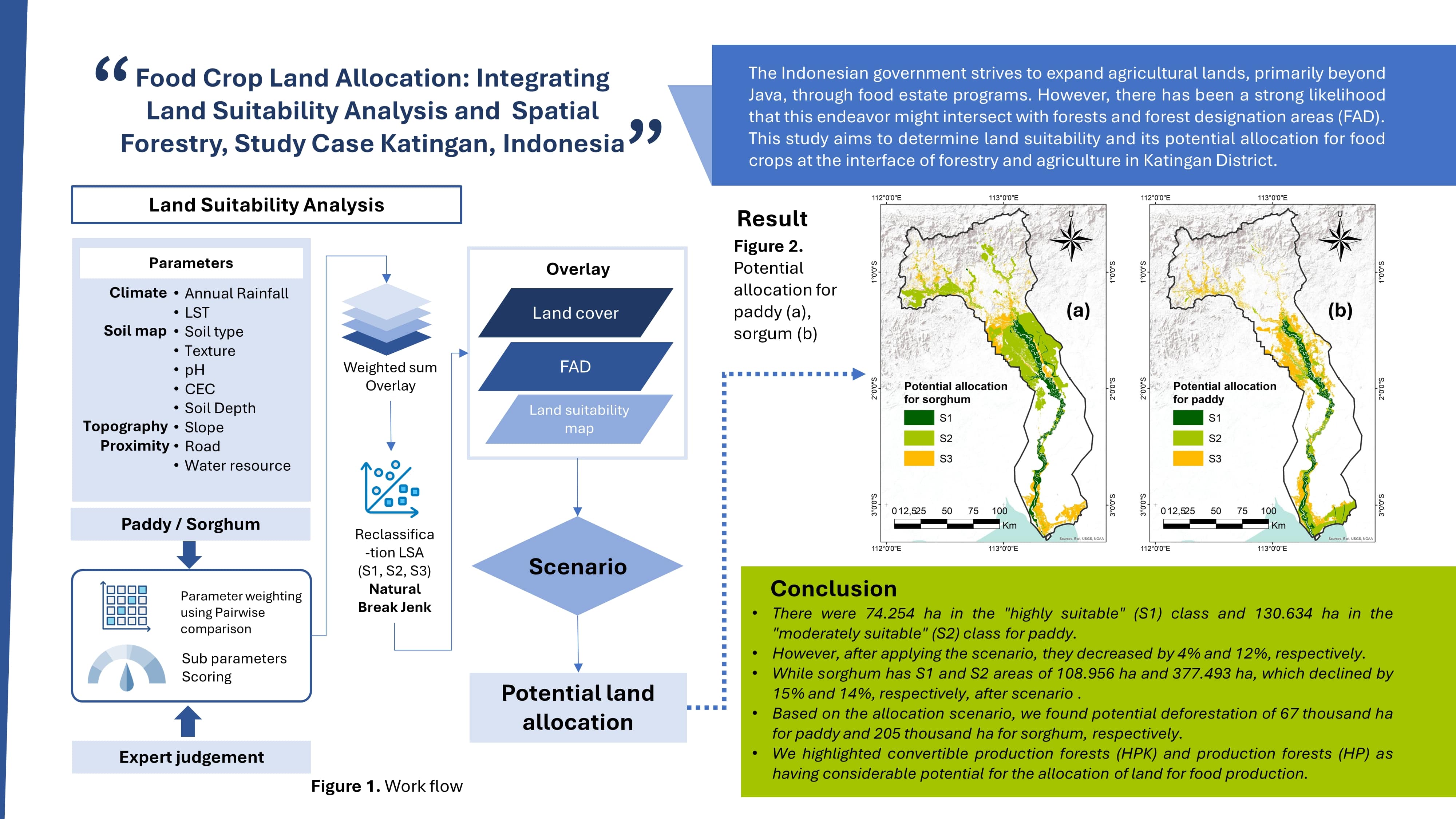
The Indonesian government strives to expand agricultural lands, primarily beyond Java, through food estate programs. However, there has been a strong likelihood that this endeavor might intersect with forests and forest designation areas. This study aims to determine land suitability and its potential allocation for food crops at the interface of forestry and agriculture in Katingan District. Paddy (Oryza sativa L) and sorghum (Sorghum bicolor L) were selected as the crop species being analyzed, employing a coupling of the analytical hierarchy process and GIS. Forest area designation and land cover maps were incorporated into land allocation scenarios. The results showed that there were 74.254 ha in the "highly suitable" (S1) class and 130.634 ha in the "moderately suitable" (S2) class for paddy. However, after applying the scenario, they decreased by 4% and 12%, respectively. Sorghum has S1 and S2 areas of 108.956 ha and 377.493 ha, which declined by 15% and 14%, respectively, after scenario. Based on the allocation scenario, we found potential deforestation of 67 thousand ha for paddy and 205 thousand ha for sorghum, respectively. We highlighted convertible production forests (HPK) and production forests (HP) as having considerable potential for the allocation of land for food production.
References
Abdelrahman, M. A. E., Natarajan, A., & Hegde, R. (2016). Assessment of land suitability and capability by integrating remote sensing and GIS for agriculture in Chamarajanagar District, Karnataka, India. Egyptian Journal of Remote Sensing and Space Science, 19(1), 125–141. https://doi.org/10.1016/j.ejrs.2016.02.001
Akinci, H., Özalp, A. Y., & Turgut, B. (2013). Agricultural land use suitability analysis using GIS and AHP technique. Computers and Electronics in Agriculture, 97, 71–82. https://doi.org/10.1016/j.compag.2013.07.006
Aprile, F., & Lorandi, R. (2012). Evaluation of cation exchange capacity (CEC) in tropical soils using four different analytical methods. Journal of Agricultural Science, 4(6), 278–289. https://doi.org/10.5539/jas.v4n6p278
Araújo Costa, R. C., Pereira, G. T., Tarlé Pissarra, T. C., Silva Siqueira, D., Sanches Fernandes, L. F., Vasconcelos, V., …, & Pacheco, F. A. L. (2019). Land capability of multiple-landform watersheds with environmental land use conflicts. Land Use Policy, 81, 689–704. https://doi.org/10.1016/j.landusepol.2018.11.041
Betts, M. G., Wolf, C., Ripple, W. J., Phalan, B., Millers, K. A., Duarte, A., …, & Levi, T. (2017). Global forest loss disproportionately erodes biodiversity in intact landscapes. Nature, 547(7664), 441–444. https://doi.org/10.1038/nature23285
Bhardwaj, M., Kumar, P., Kumar, S., Dagar, V., & Kumar, A. (2022). A district-level analysis for measuring the effects of climate change on production of agricultural crops, i.e., wheat and paddy: evidence from India. Environmental Science and Pollution Research, 29(21), 31861–31885. https://doi.org/10.1007/s11356-021-17994-2
[BPS] Badan Pusat Statistik. (2018). Luas lahan sawah. Retrieved from https://www.bps.go.id/indicator/53/179/1/luas-lahan-sawah.html
[BPS] Badan Pusat Statistik. (2021a). Hasil sensus penduduk 2020. Berita Resmi Statistik No.7/01/Th. XXIV.
[BPS] Badan Pusat Statistik. (2021b). Luas panen dan produksi padi di Indonesia 2020. Jakarta: Direktorat Statistik Tanaman Pangan, Hortikultura, dan Perkebunan.
[BPS Katingan] Badan Pusat Statistik Kabupaten Katingan. (2020). Rata-rata jumlah hujan dan curah hujan setiap bulan di Kabupaten Katingan 2015–2019. Retrieved from https://katingankab.bps.go.id/indicator/151/190/1/rata-rata-jumlah-hujan-dan-curah-hujan-setiap-bulan-di-kabupaten-katingan.html
[BPS Katingan] Badan Pusat Statistik Kabupaten Katingan. (2023). Kabupaten Katingan dalam angka 2022. Retrieved from https://katingankab.bps.go.id/publication/2023/02/28/7d6751ed6 c2f056b68069260/kabupaten-katingan-dalam-angka-2023.html
Cahya, M., Suwignyo, R. A., Sodikin, E., & Baral, H. (2022). Increasing rice productivity in degraded peatlands using improved planting methods and rice varieties. BIOVALENTIA: Biological Research Journal, 8(1), 69–82. https://doi.org/10.24233/biov.8.1.2022.246
Chen, J., Yang, S., Li, H., Zhang, B., & Lv, J. (2013). Research on geographical environment unit division based on the method of natural breaks (Jenks). International Archives of the Photogrammetry, Remote Sensing and Spatial Information Sciences-ISPRS Archives, 40(4W3), 47–50. https://doi.org/10.5194/isprsarchives-XL-4-W3-47-2013
Chen, Y., Yu, J., & Khan, S. (2010). Spatial sensitivity analysis of multi-criteria weights in GIS-based land suitability evaluation. Environmental Modelling and Software, 25(12), 1582–1591. https://doi.org/10.1016/j.envsoft.2010.06.001
de la Paix, M. J., Lanhai, L., Xi, C., Ahmed, S., & Varenyam, A. (2013). Soil degradation and altered flood risk as a consequence of deforestation. Land Degradation and Development, 24(5), 478–485. https://doi.org/10.1002/ldr.1147
Dulbari, Santosa, E., Koesmaryono, Y., & Sulistyono, D. E. (2018). Pendugaan kehilangan hasil pada tanaman padi rebah akibat terpaan angin kencang dan curah hujan tinggi. Jurnal Agronomi Indonesia, 46(1), 17–23. https://doi.org/10.24831/jai.v46i1.14376
Fahmid, I. M., Wahyudi, Agustian, A., Aldillah, R., & Gunawan, E. (2022). The potential swamp land development to support food estates programmes in Central Kalimantan, Indonesia. Environment and Urbanization ASIA, 13(1), 44–55. https://doi.org/10.1177/09754253221078178
[FAO] Food and Agriculture Organization. (1976). A framework for land evaluation. FAO Soils Bulletin 32. Rome: FAO.
[FAO] Food and Agriculture Organization. (2020). Global forest assessment resources 2020. Main report. Rome: FAO.
[FAO] Food and Agriculture Organization. (2020). Early warning early action report on food security and agriculture (April–June 2020). Rome. Retrieved from https://doi.org/10.4060/ca8606en
Gaveau, D. L. A. (2017). What a difference 4 decades make: Deforestation in Borneo since 1973. CIFOR. https://www.cifor.org/knowledge/publication/6552/
Gibbs, H. K., Ruesch, A. S., Achard, F., Clayton, M. K., Holmgren, P., Ramankutty, N., & Foley, J. A. (2010). Tropical forests were the primary sources of new agricultural land in the 1980s and 1990s. Proceedings of the National Academy of Sciences of the United States of America, 107(38), 16732–16737. https://doi.org/10.1073/PNAS.0910275107
Greene, R., Devillers, R., Luther, J. E., & Eddy, B. G. (2011). GIS-based multiple-criteria decision analysis. Geography Compass, 5(6), 412–432. https://doi.org/10.1111/j.1749-8198.2011.00431.x
Hardjowigeno, S. (1987). Ilmu tanah. Jakarta: Akademika Pressindo.
Helyar, K. R., Porter, W. M., & Robson, A. D. (1989). Soil acidity and plant growth. Sydney: Academic Press.
Huffman, G. J., Adler, R. F., Bolvin, D. T., Gu, G., Nelkin, E. J., Bowman, K. P., …, & Wolff, D. B. (2007). The TRMM multisatellite precipitation analysis (TMPA): Quasi-global, multiyear, combined-sensor precipitation estimates at fine scales. Journal of Hydrometeorology, 8(1), 38–55. https://doi.org/10.1175/JHM560.1
Hulley, G. C., Ghent, D., Göttsche, F. M., Guillevic, P. C., Mildrexler, D. J., & Coll, C. (2019). Land surface temperature. In G. C. Hulley, & D. Ghent (Eds.), Taking the temperature of the earth (pp. 57–127). Elsevier. https://doi.org/10.1016/b978-0-12-814458-9.00003-4
Kemmitt, S. J., Wright, D., Goulding, K. W. T., & Jones, D. L. (2006). pH regulation of carbon and nitrogen dynamics in two agricultural soils. Soil Biology and Biochemistry, 38(5), 898–911. https://doi.org/10.1016/j.soilbio.2005.08.006
Kihoro, J., Bosco, N. J., & Murage, H. (2013). Suitability analysis for rice growing sites using a multicriteria evaluation and GIS approach in great Mwea region, Kenya. SpringerPlus, 2(1), 1–9. https://doi.org/10.1186/2193-1801-2-265
[KLHK] Kementerian Lingkungan Hidup dan Kehutanan. (2021). Rekalkulasi penutupan lahan Indonesia tahun 2020. Jakarta: Direkorat Inventarisasi dan Pemantauan Sumber Daya Hutan. Direktorat Jenderal Planologi Kehutanan dan Tata Lingkungan. Kementerian Lingkungan Hidup dan Kehutanan RI.
Lawrence, D., & Vandecar, K. (2015). Effects of tropical deforestation on climate and agriculture. Nature Climate Change, 5(1), 27–36. https://doi.org/10.1038/nclimate2430
Massagony, A., Tam Ho, T., & Shimada, K. (2022). Climate change impact and adaptation policy effectiveness on rice production in Indonesia. International Journal of Environmental Studies, 80(5), 1373–1390. https://doi.org/10.1080/00207233.2022.2099110
Montgomery, B., Dragićević, S., Dujmović, J., & Schmidt, M. (2016). A GIS-based logic scoring of preference method for evaluation of land capability and suitability for agriculture. Computers and Electronics in Agriculture, 124, 340–353. https://doi.org/10.1016/j.compag.2016.04.013
Mustafa, A. A., Singh, M., Sahoo, R. N., Ahmed, N., Khanna, M., Sarangi, A., & Mishra, A. K. (2011). Land suitability analysis for different crops: A multi criteria decision making approach using remote sensing and GIS. Researcher, 3(12), 61–84.
Ohadi, S., Littlejohn, M., Mesgaran, M., Rooney, W., & Bagavathiannan, M. (2018). Correction: Surveying the spatial distribution of feral sorghum (Sorghum bicolor L.) and its sympatry with johnsongrass (S. halepense) in South Texas. PLoS ONE, 13(7), e0200984. https://doi.org/10.1371/journal.pone.0200984
Pramanik, M. K. (2016). Site suitability analysis for agricultural land use of Darjeeling District using AHP and GIS techniques. Modeling Earth Systems and Environment, 2(2), 56. https://doi.org/10.1007/s40808-016-0116-8
Rhoades, J. D. (1983). Cation exchange capacity. Methods of Soil Analysis: Part 2 Chemical and Microbiological Properties, 9, 149–157.
Saaty, T. L. (1980). The analytic hierarchy process. New York: McGraw-Hill.
Sarwono, H. (1995). Ilmu tanah. Jakarta: Akademik Pressindo.
Susilawati, Mokhtar, S., Elistya, S., Agustini, S., & Suparman. (2015). Inventarisasi sumberdaya genetik padi lokal spesifik Kalimantan Tengah. In T. P. Priyatno (Ed.), National conference on agricultural genetic resources: Local genetic resource management as a source of regional economic growth (274–286). IAARD Press.
Wahyunto, Hikmatullah, Suryani, E., Tafakresnanto, C., Ritung, S., Mulyani, A., …, & Nursyamsi, D. (2016). Petunjuk teknis pedoman penilaian kesesuaian lahan untuk komoditas strategis tingkat semi detail skala 1:50.000. Bogor: Balai Besar Penelitian dan Pengembangan Sumberdaya Lahan Pertanian, Badan Penelitian dan Pengembangan Pertanian.
Wan, Z., Hook, S., Hulley, G. (2015). MOD11A1 MODIS/Terra land surface temperature/emissivity daily L3 global 1km SIN Grid V006 (NASA EOSDIS Land Processes Distributed Active Archive Center) [Data set]. NASA EOSDIS. https://doi.org/10.5067/MODIS/MOD11A1.006
Widiatmaka, Ambarwulan, W., Setiawan, Y., & Walter, C. (2016). Assessing the suitability and availability of land for agriculture in tuban regency, East Java, Indonesia. Applied and Environmental Soil Science, 2016, 7302148. https://doi.org/10.1155/2016/7302148
Yalew, S. G., van Griensven, A., Mul, M. L., & van der Zaag, P. (2016). Land suitability analysis for agriculture in the Abbay basin using remote sensing, GIS and AHP techniques. Modeling Earth Systems and Environment, 2, 101. https://doi.org/10.1007/s40808-016-0167-x
Yeny, I., Garsetiasih, R., Suharti, S., Gunawan, H., Sawitri, R., Karlina, E., ..., & Takandjandji, M. (2022). Examining the socio-economic and natural resource risks of food estate development on peatlands: A strategy for economic recovery and natural resource. Sustainability, 14(7), 3961. https://doi.org/10.3390/su14073961
Zhang, J., Su, Y., Wu, J., & Liang, H. (2015). GIS based land suitability assessment for tobacco production using AHP and fuzzy set in Shandong Province of China. Computers and Electronics in Agriculture, 114, 202–211. https://doi.org/10.1016/j.compag.2015.04.004
Authors

This work is licensed under a Creative Commons Attribution 4.0 International License.
Jurnal Manajemen Hutan Tropika is an open access journal which means that all contents is freely available without charge to the user or his/her institution. Users are allowed to read, download, copy, distribute, print, search, or link to the full texts of the articles in this journal without asking prior permission from the publisher or the author. This is in accordance with the Budapest Open Access Initiative (BOAI) definition of open access.Article Details