
Monitoring of Post-fire Vegetation Succession on Peatland in Bengkalis Island, Riau Province
Article Sidebar
-
fire activity, peatland, succession
Abstract
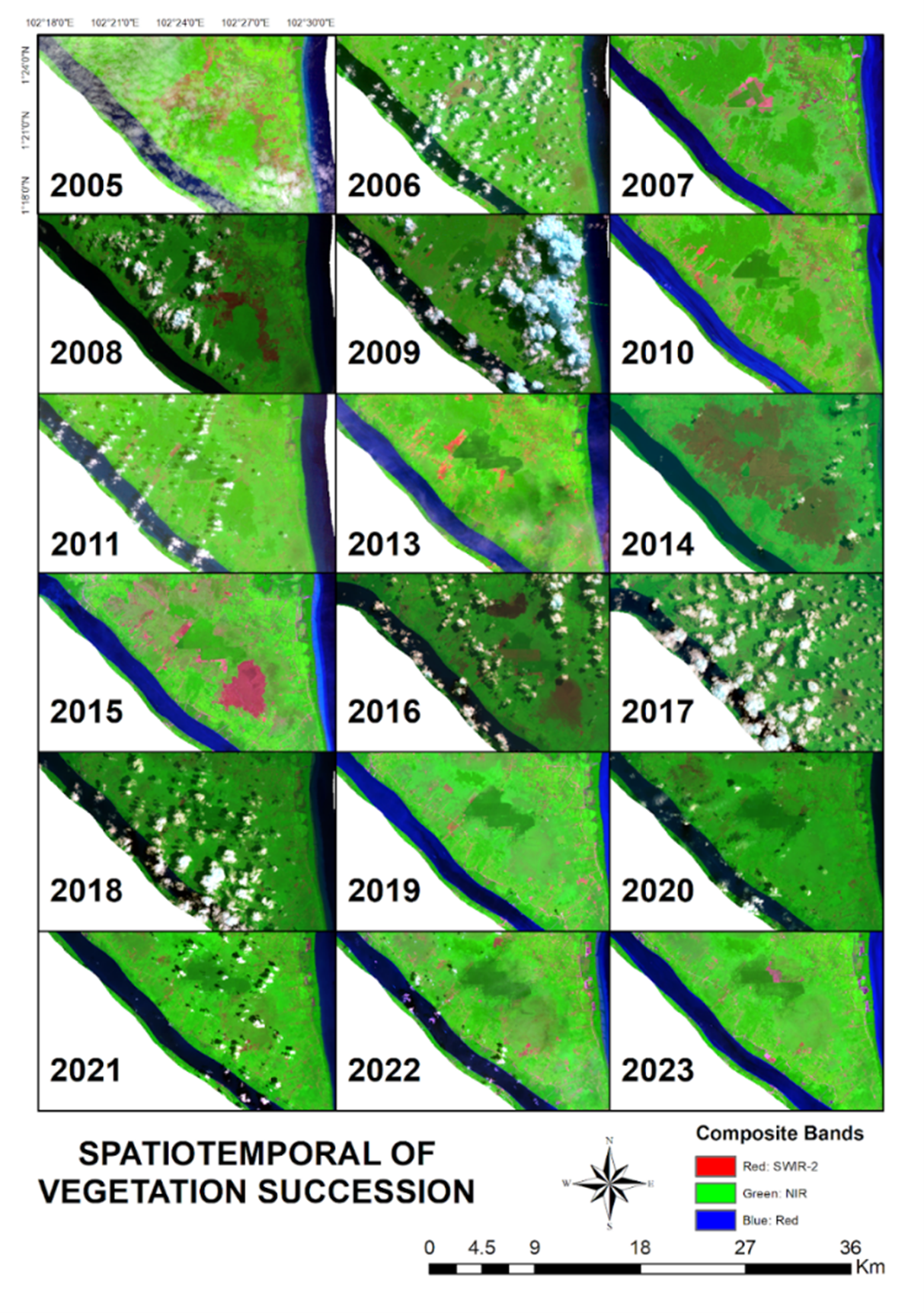
Peatlands are characterized by the accumulation of decomposed plant remains, which result in an organic carbon content of approximately 16 percent and form a layer at least 40 cm thick. Peat ecosystems play a crucial role in supporting biodiversity conservation, maintaining water availability, and regulating the climate. However, human activities threaten these functions, especially during the dry season, which often leads to extensive fires. Post-fire succession is a natural process through which the land attempts to restore its original state. Monitoring succession after peatland fires can be conducted using satellite-based remote sensing technology, which provides spatiotemporal information. This study utilized a time series of three Landsat satellites, namely Landsat 5 (TM), Landsat 8 (OLI), and Landsat 9 (OLI2), to monitor succession in burnt peat areas on Bengkalis Island from 2000 onward. Additionally, hotspot data from FIRMS NASA and MODIS were incorporated. The results showed a total of 3,689 hotspots recorded between 2005 and 2023. The confirmed land cover types in the succession area include swamps, water bodies, and oil palm plantations. The information from this research is expected to inform policymaking by the government or peatland area managers, and serve as a reference for further studies.
Full text article
References
2. Suwondo; Sabiham, S.; Sumardjo; Paramudya, B. Analisis Lingkungan Biofisik Lahan Gambut Pada Perkebunan Kelapa Sawit. Jurnal Hidrolitan 2010, 1.
3. Shepherd, H.E.R.; Martin, I.; Marin, A.; Cruijsen, P.M.J.M.; Temmink, R.J.M.; Robroek, B.J.M. Post-Fire Peatland Recovery by Peat Moss Inoculation Depends on Water Table Depth. Journal of Applied Ecology 2023, 60, 673–684, doi:10.1111/1365-2664.14360.
4. Syahza, A.; Bakce, D.; Irianti, M. Improved Peatlands Potential for Agricultural Purposes to Support Sustainable Development in Bengkalis District, Riau Province, Indonesia. In Proceedings of the Journal of Physics: Conference Series; Institute of Physics Publishing, December 18 2019; Vol. 1351.
5. Chen, H.; Lan, Y.; Fritz, B.K.; Clint Hoffmann, W.; Liu, S. Review of Agricultural Spraying Technologies for Plant Protection Using Unmanned Aerial Vehicle (Uav). International Journal of Agricultural and Biological Engineering 2021, 14, 38–49, doi:10.25165/j.ijabe.20211401.5714.
6. Masek, J.G.; Wulder, M.A.; Markham, B.; McCorkel, J.; Crawford, C.J.; Storey, J.; Jenstrom, D.T. Landsat 9: Empowering Open Science and Applications through Continuity. Remote Sens Environ 2020, 248, doi:10.1016/j.rse.2020.111968.
7. Kaita, E.; Markham, B.; Haque, M.O.; Dichmann, D.; Gerace, A.; Leigh, L.; Good, S.; Schmidt, M.; Crawford, C.J. Landsat 9 Cross Calibration Under-Fly of Landsat 8: Planning, and Execution. Remote Sens (Basel) 2022, 14, doi:10.3390/rs14215414.
8. Niroumand-Jadidi, M.; Legleiter, C.J.; Bovolo, F. River Bathymetry Retrieval from Landsat-9 Images Based on Neural Networks and Comparison to SuperDove and Sentinel-2. IEEE J Sel Top Appl Earth Obs Remote Sens 2022, 15, 5250–5260, doi:10.1109/JSTARS.2022.3187179.
9. Liu, Y.; Zhao, J.; Deng, R.; Liang, Y.; Gao, Y.; Chen, Q.; Xiong, L.; Liu, Y.; Tang, Y.; Tang, D. A Downscaled Bathymetric Mapping Approach Combining Multitemporal Landsat-8 and High Spatial Resolution Imagery: Demonstrations from Clear to Turbid Waters. ISPRS Journal of Photogrammetry and Remote Sensing 2021, 180, 65–81, doi:10.1016/j.isprsjprs.2021.07.015.
10. Hu, J.; Ye, B.; Bai, Z.; Feng, Y. Remote Sensing Monitoring of Vegetation Reclamation in the Antaibao Open-Pit Mine. Remote Sens (Basel) 2022, 14, doi:10.3390/rs14225634.
11. Sirin, A.; Medvedeva, M. Remote Sensing Mapping of Peat-Fire-Burnt Areas: Identification among Other Wildfires. Remote Sens (Basel) 2022, 14, doi:10.3390/rs14010194.
12. Aflahah, E.; Hidayati, R.; Hidayat, R.; Alfahmi, F. Hotspot Asummption as a Forest Fire Indicator in Kalimantan Based on Climate Factor. Jurnal Pengelolaan Sumberdaya Alam dan Lingkungan 2019, 9, 405–418, doi:10.29244/jpsl.9.2.405-418.
13. Harahap, F.R. Pengelolaan Lahan Basah Terkait Semakin Maraknya Kebakaran Dengan Pendekatan Adaptasi Yang Didasarkan Pada Konvesi Ramsar. Journal Society 2016, 6.
14. Yuan, X.; Tian, J.; Reinartz, P. Learning-Based Near-Infrared Band Simulation with Applications on Large-Scale Landcover Classification. Sensors 2023, 23, doi:10.3390/s23094179.
15. Li, X.; Zhang, H.; Yang, G.; Ding, Y.; Zhao, J. Post-Fire Vegetation Succession and Surface Energy Fluxes Derived from Remote Sensing. Remote Sens (Basel) 2018, 10, doi:10.3390/rs10071000.
16. van Gerrevink, M.J.; Veraverbeke, S. Evaluating the Hyperspectral Sensitivity of the Differenced Normalized Burn Ratio for Assessing Fire Severity. Remote Sens (Basel) 2021, 13, doi:10.3390/rs13224611.
17. Kala, C.P. Environmental and Socioeconomic Impacts of Forest Fires: A Call for Multilateral Cooperation and Management Interventions. Natural Hazards Research 2023, 3, 286–294, doi:10.1016/j.nhres.2023.04.003.
18. Hero Saharjo, B.; Gago, C. Bambang Hero Saharjo et al. Natural Succession After Fires at Secondary Forest in Fatuquero Village, Railaco District, Ermera Regency-Timor Leste. Jurnal Silvikultur Tropika 2011, 2.
19. Pérez-Cabello, F.; Montorio, R.; Alves, D.B. Remote Sensing Techniques to Assess Post-Fire Vegetation Recovery. Curr Opin Environ Sci Health. `, 21.
20. Wang, W.; Liu, R.; Gan, F.; Zhou, P.; Zhang, X.; Ding, L. Monitoring and Evaluating Restoration Vegetation Status in Mine Region Using Remote Sensing Data: Case Study in Inner Mongolia, China. Remote Sens (Basel) 2021, 13, doi:10.3390/rs13071350.
21. Li, Z.; Li, X.; Wei, D.; Xu, X.; Wang, H. An Assessment of Correlation on MODIS-NDVI and EVI with Natural Vegetation Coverage in Northern Hebei Province, China. In Proceedings of the Procedia Environmental Sciences; 2010; Vol. 2, pp. 964–969.
22. Hoscilo, A.; Tansey, K.J.; Page, S.E. Post-Fire Vegetation Response as a Proxy to Quantify the Magnitude of Burn Severity in Tropical Peatland. Int J Remote Sens 2013, 34, 412–433, doi:10.1080/01431161.2012.709328.
23. BBSDLP. 2019. Peta Lahan Gambut Indonesia Skala 1:50.000. Bogor: Balai Besar Sumberdaya Lahan dan Pertanian, Kementrian Pertanian.
Authors
Copyright (c) 2025 Nihawa Hajar Pudjawati, Heru Bagus Pulunggono, Rahmat Asy'Ari, Moh Zulfajrin, Lina Lathifah Nurazizah, Hanum Resti Saputri, Fathan Aldi Rivai, Yudi Setiawan

This work is licensed under a Creative Commons Attribution 4.0 International License.
Media Konservasi is an open access journal, meaning that all content is freely available without charge to the user or their institution. Users are allowed to read, download, copy, distribute, print, search, or link to the full texts of the articles in this journal without needing to request prior permission from the publisher or the author.
All articles published by Media Konservasi are licensed under the Creative Commons Attribution 4.0 International License. This allows for unrestricted use, distribution, and reproduction in any medium, provided proper credit is given to the original authors.
Authors submitting manuscripts should understand and agree that the copyright of published manuscripts is retained by the authors. Copyright encompasses the exclusive rights of authors to reproduce, distribute, and sell any part of the journal articles in all forms and media. Reproduction of any part of this journal, its storage in databases, and its transmission by any form or media is allowed without written permission from Media Konservasi.
Article Details
How to Cite


