Assessing the Relationship Between Land Surface Temperature and Vegetation Index During Revegetation Activities: A Remote Sensing Study on Berau Regency, East Kalimantan (2015-2021)
Article Sidebar
-
Revegetation, Coal Mining, Remote Sensing, Land Surface Temperature, NDVI
Abstract
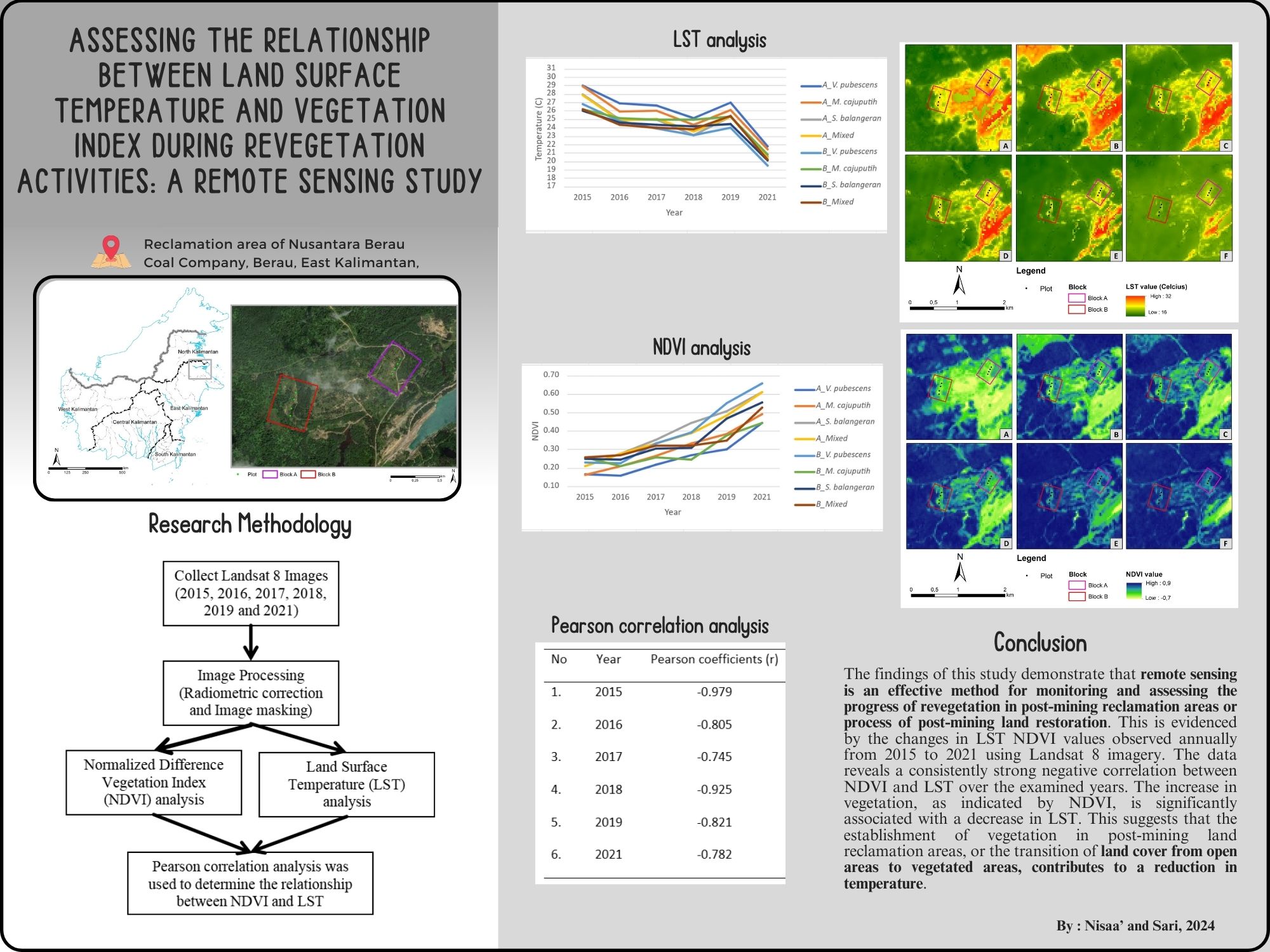
Coal mining, particularly open-pit mining methods, induces severe environmental degradation, including deforestation, loss of flora and fauna, and soil erosion. Consequently, extensive revegetation efforts are necessary to restore and rehabilitate the damaged vegetation. This study uses remote sensing techniques to investigate the correlation between land surface temperature (LST) and vegetation density over six years of revegetation activities. Temporal Landsat 8 imagery from 2015 to 2021 was used for data analysis. Image processing involved transforming the Normalized Difference Vegetation Index (NDVI) and extracting LST data. Statistical correlation analysis using Pearson correlation was employed to analyze the data. Results indicate a notable decline in land surface temperature at the project site from 2015 to 2021, attributed to the gradual reduction of open spaces from coal mining activities, which were gradually replaced by vegetation cover. Concurrently, NDVI values at the site significantly increased over the same period, indicating the successful transition from barren land to vegetated land. Moreover, a substantial correlation between LST and NDVI values was observed, as denoted by Pearson coefficient exceeding 0.7, with a strong negative correlation. This underscores the significant relationship between vegetation cover and land surface temperature dynamics. These findings emphasize the effectiveness of revegetation efforts in mitigating the adverse impacts of coal mining on the environment. They highlight the crucial role of remote sensing in monitoring and assessing the progress of rehabilitation activities, guiding future revegetation strategies for sustainable land management and ecosystem restoration.
Full text article
References
Hartman, H.L.; Mutmansky, J.M. Introductory Mining Engineering; Second.; John Wiley and Sons: United States, 2002;
Susilo, A.; Suryanto; Soegiharto, S.; Maharani, R. Status Riset Reklamasi Bekas Tambang Batubara; Samarinda, 2010;
Oktorina, S. Kebijakan Reklamasi Dan Revegetasi Lahan Bekas Tambang (Studi Kasus Tambang Batubara Indonesia). J. Tek. Lingkung. 2017, 3, 16–20.
Fawzi, N.I.; Jatmiko, R.H. Heat Island Detection in Coal Mining Areas Using Multitemporal Remote Sensing. In Proceedings of the ACRS 2015 - 36th Asian Conference on Remote Sensing: Fostering Resilient Growth in Asia, Proceedings; 2015.
Ilyas, S. The Impact of Revegetation on Microclimate in Coal Mining Areas in East Kalimantan. J. Environ. Earth Sci. 2012, 2.
Rahmatillah, S.; Husen, T. Penyalahgunaan Pengelolaan Pertambangan Terhadap Kerusakan Lingkungan Hidup Di Kecamatan Kluet Tengah. Legitimasi 2018, VII, 149–171, doi:DOI: http://dx.doi.org/10.22373/legitimasi.v7i1.3969.
Pemerintah Indonesia Undang-Undang Republik Indonesia No. 4 Tahun 2009 Tentang Pertambangan Mineral Dan Batubara; 2009;
Pemerintah Indonesia Peraturan Pemerintah Republik Indonesia Nomor 78 Tahun 2010 Tentang Reklamasi Dan Pasca Tambang; 2010;
Kementerian Energi dan Sumber Daya Mineral Peraturan Menteri Energi Dan Sumber Daya Mineral Nomor 18 Tahun 2008 Tentang Reklamasi Dan Penutupan Tambang; 2008;
Kementerian Kehutanan Peraturan Menteri Kehutanan Republik Indonesia Nomor : P.4/Menhut-II/2011 Tentang Pedoman Reklamasi Hutan; 2011;
Xia, Z.; Dai, F.; Chen, J. Study on Microclimate Effect by Revegetation on Concrete Slop in Guandi Hydropower Station. Adv. Mater. Res. 2012, 393–395, 1466–1470, doi:10.4028/www.scientific.net/AMR.393-395.1466.
Wang, R.; Hou, H.; Murayama, Y.; Derdouri, A. Spatiotemporal Analysis of Land Use / Cover Patterns and Their Relationship with Land Surface. Remote Sens. 2020, 12, 1–17, doi:doi:10.3390/rs12030440.
Andriansyah, M.; Fajri, M.; Budiyono, M.; Tumakaka, I. Sintesa Hasil Pengembangan 2015-2019; Samarinda, 2019;
Nursaputra, M.; Larekeng, S.H.; Nasri; Hamzah, A.S.; Mustari, A.S.; Arif, A.R.; Ambodo, A.P.; Lawang, Y.; Ardiansyah, A. The Use of Remote Sensing Technology in Assessing the Success of Reclamation in Post-Mining Area at PT Vale Indonesia. J. Pengelolaan Sumberd. Alam dan Lingkung. 2021, 11, 39–48, doi:10.29244/jpsl.11.1.39-48.
Mulkal; Alisastromijoyo; Aflah, N. Aplikasi Teknologi Penginderaan Jauh Untuk Pemantauan Revegetasi Lahan Reklamasi Tambang. Lingk. J. Environ. Eng. 2022, 3, 1–12, doi:10.22373/ljee.v3i2.2243.
Karan, S.K.; Samadder, S.R.; Maiti, S.K. Assessment of the Capability of Remote Sensing and GIS Techniques for Monitoring Reclamation Success in Coal Mine Degraded Lands. J. Environ. Manage. 2016, 182, 272–283, doi:10.1016/j.jenvman.2016.07.070.
USGS Using the USGS Landsat Level-1 Data Product Available online: https://www.usgs.gov/landsat-missions/using-usgs-landsat-level-1-data-product.
USGS Landsat Normalized Difference Vegetation Index Available online: https://www.usgs.gov/landsat-missions/landsat-normalized-difference-vegetation-index.
Dasuka, Y.P.; Sasmito, B.; Hani’ah Analisis Sebaran Jenis Vegetasi Hutan Alami Menggunakan Sistem Penginderaan Jauh (Studi Kasus : Jalur Pendakian Wekas Dan Selo) Alami, Hutan. J. Geod. Undip 2016, 5, 1–8, doi:https://doi.org/10.14710/jgundip.2016.11493.
Zaitunah, A.; Samsuri; Ahmad, A.G.; Safitri, R.A. Normalized Difference Vegetation Index (NDVI) Analysis for Land Cover Types Using Landsat 8 Oli in Besitang Watershed, Indonesia. In Proceedings of the IOP Conference Series: Earth and Environmental Science; 2018; pp. 1–10.
Solihin, M.A.; Putri, N. Keragaan Penggunaan Lahan Eksisting Di Hulu Sub DAS Cikapundung Berdasarkan Indeks Vegetasi Dan Temperatur Permukaan Lahan. J. Agrik. 2020, 31, 251–262, doi:https://doi.org/10.24198/agrikultura.v31i3.29467.
Fawzi, N.I. Pemetaan Emisivitas Permukaan Menggunakan Indeks Vegetasi. Maj. Ilm. Globë 2014, 16.
Zhang, X.; Wu, S.; Yan, X.; Chen, Z. A Global Classification of Vegetation Based on NDVI, Rainfall and Temperature. Int. J. Climatol. 2017, 37, 2318–2324, doi:10.1002/joc.4847.
Hutayanon, T.; Somprasong, K. Application of Integrated Spatial Analysis and NDVI for Tree Monitoring in Reclamation Area of Coal Mine. Environ. Sci. Pollut. Res. 2023, doi:10.1007/s11356-023-28910-1.
Nugroho, A.W.; Yassir, I. Kebijakan Penilaian Keberhasilan Reklamasi Lahan Pasca-Tambang Batubara Di Indonesia. J. Anal. Kebijak. Kehutan. 2017, 14, 121–136.
NASA NASA, NOAA Analyses Reveal 2019 Second Warmest Year on Record Available online: https://www.nasa.gov/news-release/nasa-noaa-analyses-reveal-2019-second-warmest-year-on-record/.
Fajri, M.; Ngatiman; Nisaa’, R.M. Laporan Kegiatan Pengembangan Model Revegetasi Lahan Pasca Tambang Batu Bara Di Kalimantan Timur; Samarinda, 2021;
Fajri, M. Rehabilitation of Post Mining Land of Class C with Dipterocarp Species. J. Penelit. Ekosist. Dipterokarpa 2020, 6, 1–16, doi:http://doi.org/10.20886/jped.2020.6.1.1-16.
Zhao, Y.; Li, X. rong; Zhang, P.; Hu, Y. gang; Huang, L. Effects of Vegetation Reclamation on Temperature and Humidity Properties of a Dumpsite: A Case Study in the Open Pit Coal Mine of Heidaigou. Arid L. Res. Manag. 2015, 29, 375–381, doi:10.1080/15324982.2014.962192.
Chen, L.; Li, M.; Huang, F.; Xu, S. Relationships of LST to NDBI and NDVI in Wuhan City Based on Landsat ETM+ Image. In Proceedings of the 2013 6th International Congress on Image and Signal Processing (CISP); IEEE, December 2013; pp. 840–845.
Govil, H.; Guha, S.; Diwan, P.; Gill, N.; Dey, A. Analyzing Linear Relationships of LST with NDVI and MNDISI Using Various Resolution Levels of Landsat 8 OLI and TIRS Data. In Data Management, Analytics and Innovation. Advances in Intelligent Systems and Computing; Sharma, N., Chakrabarti, A., Balas, V., Eds.; Springer, Singapore, 2020; pp. 171–184.
Trimanto; Hapsari, L.; Budiharta, S. Integrating Indicators of Natural Regeneration, Enrichment Planting, above-Ground Carbon Stock, Micro-Climate and Soil to Asses Vegetation Succession in Postmining Reclamation in Tropical Forest. Turk. J. Botany 2021, 45, 457–467, doi:10.3906/bot-2103-35.
Yue, W.; Xu, J.; Tan, W.; Xu, L. The Relationship between Land Surface Temperature and NDVI with Remote Sensing: Application to Shanghai Landsat 7 ETM+ Data. Int. J. Remote Sens. 2007, 28, 3205–3226, doi:10.1080/01431160500306906.
Authors
Media Konservasi is an open access journal, meaning that all content is freely available without charge to the user or their institution. Users are allowed to read, download, copy, distribute, print, search, or link to the full texts of the articles in this journal without needing to request prior permission from the publisher or the author.
All articles published by Media Konservasi are licensed under the Creative Commons Attribution 4.0 International License. This allows for unrestricted use, distribution, and reproduction in any medium, provided proper credit is given to the original authors.
Authors submitting manuscripts should understand and agree that the copyright of published manuscripts is retained by the authors. Copyright encompasses the exclusive rights of authors to reproduce, distribute, and sell any part of the journal articles in all forms and media. Reproduction of any part of this journal, its storage in databases, and its transmission by any form or media is allowed without written permission from Media Konservasi.
Article Details
How to Cite