
Food Self-Sufficiency Based on Local Rice in Flood-Prone Areas of Katingan Regency, Central Kalimantan
Article Sidebar
-
Flood-Prone Level, Land Suitability Evaluation, Local Food, Multi Criteria Decision Making, Spatial Planning
Abstract
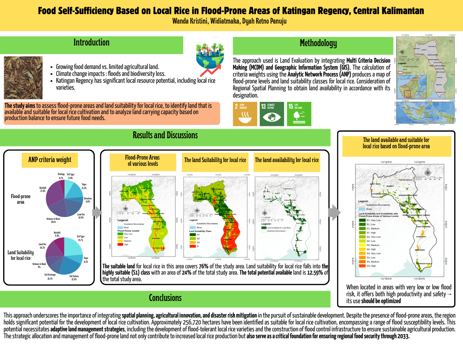
Land resources are the fundamental matrix for providing indispensable food sources. The increasing demand for food necessitates the expansion of land dedicated to food production. Katingan Regency has sufficient land resource potential for local food development but faces natural challenges such as flooding and declining food production. Land suitability evaluation is crucial for planning land use to achieve a sustainable food system. This study aims to identify, analyze, and evaluate the suitability and availability of land for local rice areas in Katingan Regency. The approach used is land suitability evaluation, which integrates multicriteria decision-making (MCDM) and geographical information systems (GIS). The criteria weights were calculated using the Analytic Network Process (ANP), producing flood risk maps and land suitability classes for local food. Spatial Planning considerations were employed to obtain land availability according to its designation. The study results show that approximately 76% of Katingan Regency area is suitable for local rice farming. Land classified as highly suitable (S1) for local rice accounts for 7% or 136,130 hectares, with shallow flood-prone level areas reaching 3,890 hectares. According to food balance projections, Katingan Regency ies expected to face a rice deficit by 2050. This research is expected to help formulate efficient land use regulations to increase local food production while preserving biodiversity. Additionally, it provides a foundation for strategic measures that can be taken to ensure long-term resilience, environmental conservation and ecological sustainability in Katingan Regency.
Full text article
References
2.1. FAO; IFAD; UNICEF; WFP; WHO The State of Food Security and Nutrition in the World 2019: Safeguarding against Economic Slowdowns and Downturns; FAO: Rome, 2019; ISBN 9251315701..
3.Pereira, P.; Brevik, E.; Trevisani, S. Mapping the Environment. Sci. Total Environ. 2018, 610–611, 17–23, doi:10.1016/j.scitotenv.2017.08.001.
4.Avtar, R.; Aggarwal, R.; Kharrazi, A.; Kumar, P.; Kurniawan, T.A. Utilizing Geospatial Information to Implement SDGs and Monitor Their Progress. Environ. Monit. Assess. 2020, 192, doi:10.1007/s10661-019-7996-9.
5.Xu, J.; Jiao, C.; Zheng, D.; Li, L. Agricultural Land Suitability Assessment at the County Scale in Taiyuan, China. Agric. 2024, 14, doi:10.3390/agriculture14010016.
6.Yang, S.; Zhao, W.; Liu, Y.; Cherubini, F.; Fu, B.; Pereira, P. Prioritizing Sustainable Development Goals and Linking Them to Ecosystem Services: A Global Expert’s Knowledge Evaluation. Geogr. Sustain. 2020, 1, 321–330, doi:10.1016/j.geosus.2020.09.004.
7.Goucher, L.; Bruce, R.; Cameron, D.D.; Lenny Koh, S.C.; Horton, P. The Environmental Impact of Fertilizer Embodied in a Wheat-to-Bread Supply Chain. Nat. Plants 2017, 3, 1–5, doi:10.1038/nplants.2017.12.
8.Sánchez-Bayo, F.; Wyckhuys, K.A.G. Worldwide Decline of the Entomofauna: A Review of Its Drivers. Biol. Conserv. 2019, 232, 8–27, doi:10.1016/j.biocon.2019.01.020.
9.Lynch, J.; Cain, M.; Frame, D.; Pierrehumbert, R. Agriculture’s Contribution to Climate Change and Role in Mitigation Is Distinct From Predominantly Fossil CO2-Emitting Sectors. Front. Sustain. Food Syst. 2021, 4, 1–9, doi:10.3389/fsufs.2020.518039.
10.Sarwono, H.; Widiatmaka Land Suitability Evaluation and Land Use Planning(In Indonesia); Gadjah Mada University Press ; Yogjakarta, 2017;
11.Han, C.; Chen, S.; Yu, Y.; Xu, Z.; Zhu, B.; Xu, X.; Wang, Z. Evaluation of Agricultural Land Suitability Based on RS, AHP, and MEA: A Case Study in Jilin Province, China. Agric. 2021, 11, doi:10.3390/agriculture11040370.
12.Gomes, E.; Inácio, M.; Bogdzevič, K.; Kalinauskas, M.; Karnauskaitė, D.; Pereira, P. Future Land-Use Changes and Its Impacts on Terrestrial Ecosystem Services: A Review. Sci. Total Environ. 2021, 781, doi:10.1016/j.scitotenv.2021.146716.
13.Viana, C.M.; Freire, D.; Abrantes, P.; Rocha, J.; Pereira, P. Agricultural Land Systems Importance for Supporting Food Security and Sustainable Development Goals: A Systematic Review. Sci. Total Environ. 2022, 806, doi:10.1016/j.scitotenv.2021.150718.
14.Choudhary, K.; Boori; Shi, W.; Valiev, A.; Kupriyanov, A. Agricultural Land Suitability Assessment for Sustainable Development Using Remote Sensing Techniques with Analytic Hierarchy Process. Remote Sensing Applications Society and Environment 2023, 32, 101051, doi:10.1016/j.rsase.2023.101051.
15.Tashayo, B.; Honarbakhsh, A.; Akbari, M.; Eftekhari, M. Land Suitability Assessment for Maize Farming Using a GIS-AHP Method for a Semi- Arid Region, Iran. J. Saudi Soc. Agric. Sci. 2020, 19, 332–338, doi:10.1016/j.jssas.2020.03.003.
16.Sakinah, R.; Surtikanti, H.K. Efforts to preserve agriculture by the Dayak Meratus community based on local wisdom Manugal: A Literature Study. J. Socio-Cultural Sustain. Resil. 2024, 1, 119–126, doi:10.61511/jscsr.v1i2.2024.427.
17.Susilawati; Mokthar, S.; Elistya, S.; Agustini, S.; Suparman Inventorisation of specific local paddy genetic resources of Central Kalimantan (In Indonesia). Balai Besar Penelit. Tanam. Padi 2015, 613–620.
18.Felisya, T.; Redin, H.; Darung, U.Inventorisation and characterisation of local paddy in swampland in Pulau Malan sub-district, Katinga Regency (In Indonesia). J. Agribus. Agrotechnology 2022, 3, 66–78.
19.BPS Kabupaten Katingan Kabupaten Katingan Dalam Angka 2024; BPS Kabupaten Katingan: Kasongan, 2024; ISBN 9786026376046.
20.Marciatie, L.; Redin, H.; Prajawahyudo, T. Strategy for poverty reduction through rice farming development in Rural Katingan Regency (In Indonesia) J. Environ. Manag. 2022, 3, 62–70, doi:10.37304/jem.v3i1.4288.
21.Mustapa, L.A.; Purnamadewi, Y.L.; Dharmawan, A.H. Impact and sustainability of the rice field printing programme in Katingan District, Central Kalimantan Province (In Indonesia). Anal. Kebijak. Pertan. 2019, 17, 123, doi:10.21082/akp.v17n2.2019.123-137.
22.Bonou, A.; Egah, J.; Aihounton, G.B.D. Impact of Floods on Rice Production in West Africa: Micro-Evidence from Benin. Sustain. Environ. 2024, 10, doi:10.1080/27658511.2024.2356396.
23.BPS Kabupaten Katingan Kabupaten Katingan Dalam Angka 2023; BPS Kabupaten Katingan: Kasongan, 2023; ISBN 0215-2371.
24.Ahmad, F.; Uddin, M.M.; Goparaju, L.; Rizvi, J.; Biradar, C. Quantification of the Land Potential for Scaling Agroforestry in South Asia. KN - J. Cartogr. Geogr. Inf. 2020, 70, 71–89, doi:10.1007/s42489-020-00045-0.
25.Sathiyamurthi, S.; Saravanan, S.; Karuppannan, S.; Balakumbahan, R.; Sivasakthi, M.; Praveen Kumar, S.; Ramya, M.; Hussain, S.; Tariq, A. Agricultural Land Suitability of Manimutha Nadhi Watershed Using AHP and GIS Techniques. Discov. Sustain. 2024, 5, 270, doi:10.1007/s43621-024-00471-4.
26.Widiatmaka; Ambarwulan, W.; Setiawan, Y.; Walter, C. Assessing the Suitability and Availability of Land for Agriculture in Tuban Regency, East Java, Indonesia. Appl. Environ. Soil Sci. 2016, 2016, doi:10.1155/2016/7302148.
27.Artikanur, S.D.; Widiatmaka; Setiawan, Y.; Marimin An Evaluation of Possible Sugarcane Plantations Expansion Areas in Lamongan , East Java , Indonesia. Sustainability 2023, 15, 1–17, doi:https://doi.org/10.3390/su15065390.
28.Saaty, T.L. Fundamentals of the analytic network process-dependence and feedback in decision-making with a single network. J.Syst. Sci. Syst. Eng. 2004, 13, 129–157.
29.Ozkaya, G.; Erdin, C. Evaluation of Smart and Sustainable Cities through a Hybrid MCDM Approach Based on ANP and TOPSIS Technique. Heliyon 2020, 6, e05052, doi:10.1016/j.heliyon.2020.e05052.
30.Aliani, H.; Ghanbari Motlagh, M.; Danesh, G.; Aliani, H. Land Suitability Analysis for Urban Development Using TOPSIS, WLC and ANP Techniques (Eastern Cities of Gilan-Iran). Arab. J. Geosci. 2021, 14, doi:10.1007/s12517-021-07606-1.
31.Xu, J.; Li, L.; Ren, M. A Hybrid ANP Method for Evaluation of Government Data Sustainability. Sustain. 2022, 14, 1–32, doi:10.3390/su14020884.
32.Pamucar, D.; Gigovic, L.; Bajic, Z.; Janoševic, M. Location Selection for Wind Farms Using GIS Multi-Criteria Hybrid Model: An Approach Based on Fuzzy and Rough Numbers. Sustain. 2017, 9, doi:10.3390/su9081315.
33.Wang, Y.; Cao, Y.; Wang, S.; Su, H. Clutter Suppression and Ground Moving Target Imaging Approach for Hypersonic Vehicle Borne Multichannel Radar Based on Two-Step Focusing Method. Digit. Signal Process. A Rev. J. 2019, 85, 62–76, doi:10.1016/j.dsp.2018.11.008.
34.Ministry of Agriculture Republic of Indonesia Statistics of Food Consumption 2023; 2023; ISBN 2013206534.
35.Al-Eideh, B.M.; Al-Omar, H.O. Population Projection Model Using Exponential Growth Function with a Birth and Death Diffusion. Eur. J. Sci. Res. 2019, 151, 271–276.
36.Yariyan, P.; Avand, M.; Abbaspour, R.A.; Torabi Haghighi, A.; Costache, R.; Ghorbanzadeh, O.; Janizadeh, S.; Blaschke, T. Flood Susceptibility Mapping Using an Improved Analytic Network Process with Statistical Models. Geomatics, Nat. Hazards Risk 2020, 11, 2282–2314, doi:10.1080/19475705.2020.1836036.
37.Chukwuma, E.C.; Okonkwo, C.C.; Ojediran, J.O.; Anizoba, D.C.; Ubah, J.I.; Nwachukwu, C.P. A Gis Based Flood Vulnerability Modelling Of Anambra State Using An Integrated Ivfrn-Dematel-Anp Model. Heliyon 2021, 7, e08048, doi:10.1016/j.heliyon.2021.e08048.
38.Riaz, R.; Mohiuddin, M. Application of GIS-Based Multi-Criteria Decision Analysis of Hydro-Geomorphological Factors for Flash Flood Susceptibility Mapping in Bangladesh. Water Cycle 2024, 134226, doi:10.1016/j.watcyc.2024.09.003.
39.Abuzwidah, M.; Elawady, A.; Ashour, A.G.; Yilmaz, A.G.; Shanableh, A.; Zeiada, W. Flood Risk Assessment for Sustainable Transportation Planning and Development under Climate Change: A GIS-Based Comparative Analysis of CMIP6 Scenarios. Sustain. 2024, 16, doi:10.3390/su16145939.
40.Handiani, D.N.; Purnomo, D. Evaluation of Floods Susceptibility Models Based on Different Pairwise Parameters in the Analytical Hierarchy Process: Case Study Cilemer and Ciliman Watersheds. J Nat. Resour. Environ. Manag. 2024, 14, 684, doi:10.29244/jpsl.14.4.684.
41.Ramdhani; Widiatmaka; Trisasongko, B.H. Food Crop Land Allocation: Integrating Land Suitability Analysis and Spatial Forestry, Study Case Katingan, Indonesia. J. Manaj. Hutan Trop. 2023, 29, 187–199, doi:10.7226/jtfm.29.3.187.
42.Talukdar, S.; Ghose, B.; Shahfahad; Salam, R.; Mahato, S.; Pham, Q.B.; Linh, N.T.T.; Costache, R.; Avand, M. Flood Susceptibility Modeling in Teesta River Basin, Bangladesh Using Novel Ensembles of Bagging Algorithms. Stoch. Environ. Res. Risk Assess. 2020, 34, 2277–2300, doi:10.1007/s00477-020-01862-5.
43.Ibrahim-Bathis, K.; Ahmed, S.A. Geospatial Technology for Delineating Groundwater Potential Zones in Doddahalla Watershed of Chitradurga District, India. Egypt. J. Remote Sens. Sp. Sci. 2016, 19, 223–234, doi:10.1016/j.ejrs.2016.06.002.
44.Rimba, A.; Setiawati, M.; Sambah, A.; Miura, F. Physical Flood Vulnerability Mapping Applying Geospatial Techniques in Okazaki City, Aichi Prefecture, Japan. Urban Sci. 2017, 1, 7, doi:10.3390/urbansci1010007.
45.Cabrera, J.S.; Lee, H.S. Flood-Prone Area Assessment Using GIS-Based Multi-Criteria Analysis: A Case Study in Davao Oriental, Philippines. Water (Switzerland) 2019, 11, doi:10.3390/w11112203.
46.Haque, M.N.; Siddika, S.; Sresto, M.A.; Saroar, M.M.; Shabab, K.R. Geo-Spatial Analysis for Flash Flood Susceptibility Mapping in the North-East Haor (Wetland) Region in Bangladesh. Earth Syst. Environ. 2021, 5, 365–384, doi:10.1007/s41748-021-00221-w.
47.Benito, G.; Ballesteros-Cánovas, J.A.; Díez-Herrero, A. Chapter 2 - Paleoflood Hydrology: Reconstructing Rare Events and Extreme Flood Discharges. In Hydro-Meteorological Hazards, Risks, and Disasters (Second Edition); Shroder, J.F., Paron, P., Baldassarre, G. Di, Eds.; Elsevier, 2023; p. 5 ISBN 1251006011111.
48.Adrian; Widiatmaka; Munibah, K.; Firmansyah, I. Evaluate Land Suitability Analysis for Rice Cultivation Using a GIS-Based AHP Multi-Criteria Decision-Making Approach: Majalengka Regency, West Java Province. IOP Conf. Ser. Earth Environ. Sci. 2022, 1109, doi:10.1088/1755-1315/1109/1/012062.
49.Al-Hanbali, A.; Shibuta, K.; Alsaaideh, B.; Tawara, Y. Analysis of the Land Suitability for Paddy Fields in Tanzania Using a GIS-Based Analytical Hierarchy Process. Geo-Spatial Inf. Sci. 2022, 25, 212–228, doi:10.1080/10095020.2021.2004079.
50.Tolche, A.D.; Gurara, M.A.;Pham, Q.B. et al. Agricultural land use suitability analysis using AHP and GIS techniques at basin scale. Arab J Geosci. 2022, 15, 1522 doi.org/10.1007/s12517-022-10799-8
51.Bella, R.; Stevany; Gujali, A.I.; Dewi, R.S.; Lion, E.; Mustika, M. The community system and organization of the Dayak Ngaju Tribe (Case Study in Mandomai Village, Central Kalimantan) (In Indonesia). J. Citizenship 2021, 5, 364–375.doi.org/10.31316/jk.v5i2.1676
52.Morton, L.W.; Olson, K.R. Addressing Soil Degradation and Flood Risk Decision Making in Levee Protected Agricultural Lands under Increasingly Variable Climate Conditions. J. Environ. Prot. (Irvine,. Calif). 2014, 05, 1220–1234, doi:10.4236/jep.2014.512117.
53.Janizadeh, S.; Avand, M.; Jaafari, A.; Van Phong, T.; Bayat, M.; Ahmadisharaf, E.; Prakash, I.; Pham, B.T.; Lee, S. Prediction Success of Machine Learning Methods for Flash Flood Susceptibility Mapping in the Tafresh Watershed, Iran. Sustain. 2019, 11, 1–19, doi:10.3390/su11195426.
54.Cahya, M.; Suwignyo, R.A.; Sodikin, E.; Baral, H. Incresing Rice Productivity in Degraded Peatlands Using Improved Planting Methots and Rice Varietas. BIOVALENTIA Biol. Res. J. 2022, 8, 32–38, doi:10.24233/biov.7.1.2021.214.
55.Arista, N.I.D.; Alifia, A.D.; Mubarok, H.; Arta, I.M.S.D.; Rizva, D.N.; Wicaksono, A.I. Availability and Potential for Expansion of Agricultural Land in Indonesia. J. Sustain. Soc. Eco-Welfare 2023, 1, 1–16, doi:10.61511/jssew.v1i1.2023.242.
56.Raghu, P.T.; Veettil, P.C.; Das, S. Smallholder Adaptation to Flood Risks: Adoption and Impact of Swarna-Sub1 in Eastern India. Environ. Challenges 2022, 7, 100480, doi:10.1016/j.envc.2022.100480.
57.Michael, P.S.; Mwakyusa, L.; Sanga, H.G.; Shitindi, M.J.; Kwaslema, D.R.; Herzog, M.; Meliyo, J.L.; Massawe, B.H.J. Floods Stress in Lowland Rice Production: Experiences of Rice Farmers in Kilombero and Lower-Rufiji Floodplains, Tanzania. Front. Sustain. Food Syst. 2023, 7, doi:10.3389/fsufs.2023.1206754.
58.Baaken, M.C. Sustainability of Agricultural Practices in Germany: A Literature Review along Multiple Environmental Domains. Reg. Environ. Chang. 2022, 22, doi:10.1007/s10113-022-01892-5.
59.Osawa, T. Environmental and Sustainability Indicators Agricultural Land around River Confluences Could Strongly Suppress Floods Occurrences. Environ. Sustain. Indic. 2024, 100533, doi:10.1016/j.indic.2024.100533.
Authors
Copyright (c) 2025 Wanda Kristini, Widiatmaka, Dyah Retno Panuju

This work is licensed under a Creative Commons Attribution 4.0 International License.
Authors who publish with this journal agree to the following terms:
- Authors retain copyright and grant the journal right of first publication with the work simultaneously licensed under a Creative Commons Attribution License that allows others to share the work with an acknowledgement of the work's authorship and initial publication in this journal.
- Authors are able to enter into separate, additional contractual arrangements for the non-exclusive distribution of the journal's published version of the work (e.g., post it to an institutional repository or publish it in a book), with an acknowledgement of its initial publication in this journal.
- Authors are permitted and encouraged to post their work online (e.g., in institutional repositories or on their website) prior to and during the submission process, as it can lead to productive exchanges, as well as earlier and greater citation of published work (See The Effect of Open Access).
Article Details
How to Cite


