
Changes Detection of Mangrove Vegetation Area in Banyak Islands Marine Natural Park, Sumatra, Southeast Asia
Article Sidebar
-
Conservation, Remote Sensing, Landsat, ALOS PALSAR, Google Earth Engine
Abstract
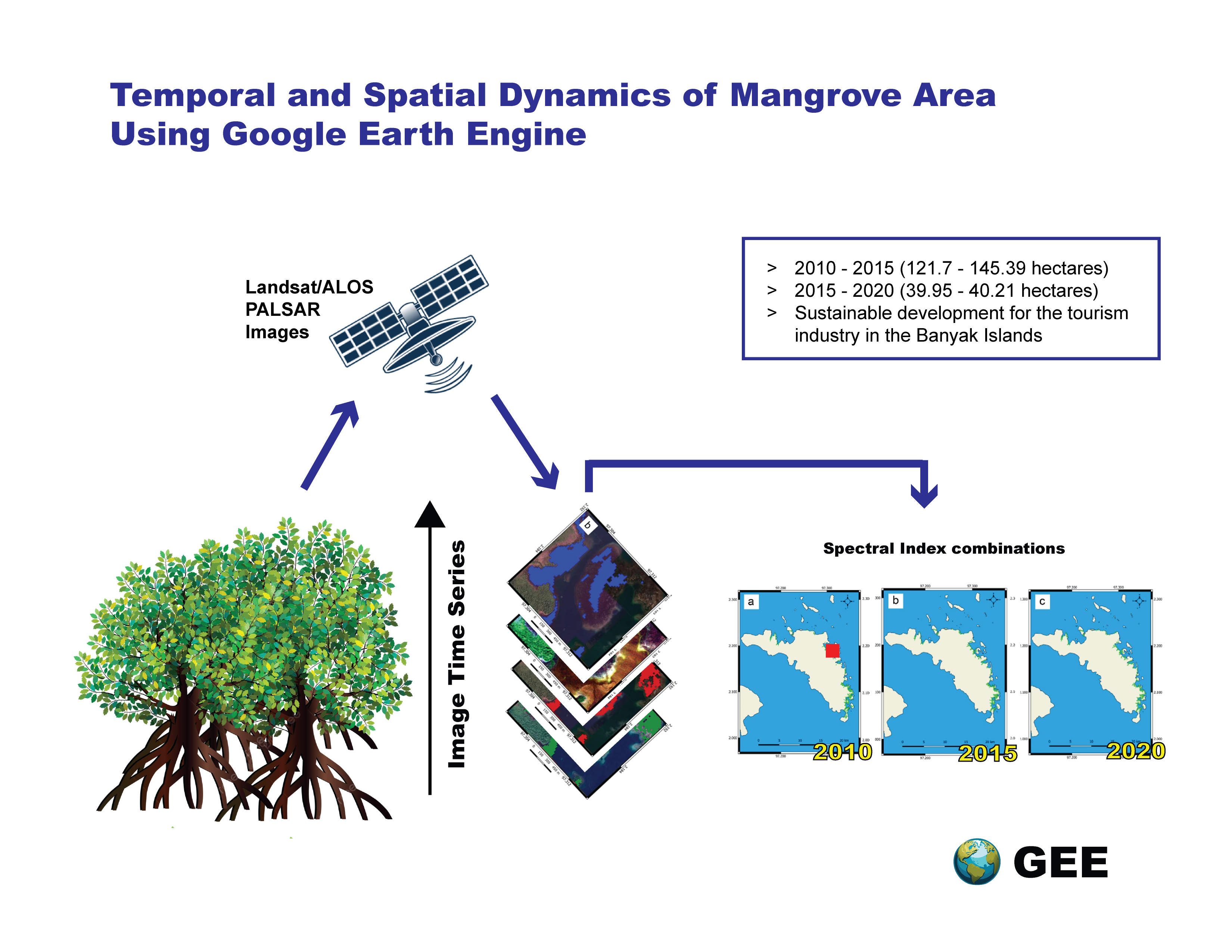
The mangrove ecosystem in the Banyak Islands faces urgent challenges due to environmental pressures, highlighting the need for accurate identification and conservation efforts. Mangrove forests provide crucial ecological benefits, making their preservation vital for sustainable regional development. To address these challenges, this study analyzed changes in mangrove vegetation on Tuangku Island, part of the Banyak Islands Marine Natural Park (BIMNP), over a decade (2010–2020). The methodology utilized Landsat imagery and ALOS PALSAR data, which were analyzed through the Google Earth Engine platform. Spectral index combinations, including NDVI, NDMI, MNDWI, and MVI, were analyzed using random forest classification, a tree-based machine learning algorithm. The study's methodology revealed that the total estimated mangrove area was 818.21 hectares in 2010, increased to 939.91 hectares in 2015, and then slightly decreased to 899.96 hectares in 2020. These findings indicate an initial expansion of mangrove vegetation followed by a decline, suggesting fluctuating environmental conditions or human impact over the period studied. The findings highlight the critical need for continuous monitoring and adaptive management practices to support the long-term sustainability of the mangrove ecosystem within the BIMNP. Based on these findings, we recommend implementing targeted conservation measures and further research to understand the underlying causes of the observed changes, thereby supporting the region's sustainable development and ecological health.
Full text article
References
Lee, T.-M.; Yeh, H.-C. Applying remote sensing techniques to monitor shifting wetland vegetation: A case study of Danshui River estuary mangrove communities, Taiwan. Ecol. Eng. 2009, 35, 487–496, doi:10.1016/j.ecoleng.2008.01.007. DOI: https://doi.org/10.1016/j.ecoleng.2008.01.007
Giri, C.; Ochieng, E.; Tieszen, L.L.; Zhu, Z.; Singh, A.; Loveland, T.; Masek, J.; Duke, N. Status and distribution of mangrove forests of the world using earth observation satellite data. Glob. Ecol. Biogeogr. 2011, 20, 154–159, doi:10.1111/j.1466-8238.2010.00584.x. DOI: https://doi.org/10.1111/j.1466-8238.2010.00584.x
Rahman, A.F.; Dragoni, D.; Didan, K.; Barreto-Munoz, A.; Hutabarat, J.A. Detecting large scale conversion of mangroves to aquaculture with change point and mixed-pixel analyses of high-fidelity MODIS data. Remote Sens. Environ. 2013, 130, 96–107, doi:10.1016/j.rse.2012.11.014. DOI: https://doi.org/10.1016/j.rse.2012.11.014
Abdul Aziz, A.; Phinn, S.; Dargusch, P. Investigating the decline of ecosystem services in a production mangrove forest using Landsat and object-based image analysis. Estuar. Coast. Shelf Sci. 2015, 164, 353–366, doi:10.1016/j.ecss.2015.07.047. DOI: https://doi.org/10.1016/j.ecss.2015.07.047
Donato, D.C.; Kauffman, J.B.; Murdiyarso, D.; Kurnianto, S.; Stidham, M.; Kanninen, M. Mangroves among the most carbon-rich forests in the tropics. Nat. Geosci. 2011, 4, 293–297, doi:10.1038/ngeo1123. DOI: https://doi.org/10.1038/ngeo1123
Kirui, K.B.; Kairo, J.G.; Bosire, J.; Viergever, K.M.; Rudra, S.; Huxham, M.; Briers, R.A. Mapping of mangrove forest land cover change along the Kenya coastline using Landsat imagery. Ocean Coast. Manag. 2013, 83, 19–24, doi:10.1016/j.ocecoaman.2011.12.004. DOI: https://doi.org/10.1016/j.ocecoaman.2011.12.004
FAO The world’s mangroves 1980–2005. FAO For. Pap. 153, Rome Food Agric. Organ. United Nations 2007.
Ilman, M.; Dargusch, P.; Dart, P.; Onrizal A historical analysis of the drivers of loss and degradation of Indonesia’s mangroves. Land use policy 2016, 54, 448–459, doi:10.1016/j.landusepol.2016.03.010. DOI: https://doi.org/10.1016/j.landusepol.2016.03.010
Nurkin, B. Degradation of mangrove forests in South Sulawesi, Indonesia. Hydrobiologia 1994, 285, 271–276, doi:10.1007/BF00005673. DOI: https://doi.org/10.1007/978-94-011-0958-1_26
Giri, C.; Zhu, Z.; Tieszen, L.L.; Singh, A.; Gillette, S.; Kelmelis, J.A. Mangrove forest distributions and dynamics (1975–2005) of the tsunami-affected region of Asia. J. Biogeogr. 2008, 35, 519–528, doi:10.1111/j.1365-2699.2007.01806.x. DOI: https://doi.org/10.1111/j.1365-2699.2007.01806.x
Giri, C.; Long, J.; Abbas, S.; Murali, R.M.; Qamer, F.M.; Pengra, B.; Thau, D. Distribution and dynamics of mangrove forests of South Asia. J. Environ. Manage. 2015, 148, 101–111, doi:10.1016/j.jenvman.2014.01.020. DOI: https://doi.org/10.1016/j.jenvman.2014.01.020
McCarthy, M.J.; Merton, E.J.; Muller-Karger, F.E. Improved coastal wetland mapping using very-high 2-meter spatial resolution imagery. Int. J. Appl. Earth Obs. Geoinf. 2015, 40, 11–18, doi:10.1016/j.jag.2015.03.011. DOI: https://doi.org/10.1016/j.jag.2015.03.011
Hamilton, S.E.; Casey, D. Creation of a high spatio-temporal resolution global database of continuous mangrove forest cover for the 21st century (CGMFC-21). Glob. Ecol. Biogeogr. 2016, 25, 729–738, doi:10.1111/geb.12449. DOI: https://doi.org/10.1111/geb.12449
Purnawan, S.; Aulia, F.; Khairuman, T. Using Landsat-8 Imagery Data on Mapping of The Seagrass Distribution in Matahari Island, Pulau Banyak District, Aceh Province, Indonesia. Aceh Int. J. Sci. Technol. 2016, 5, 63–68, doi:10.13170/aijst.5.2.4928. DOI: https://doi.org/10.13170/aijst.5.2.4928
Razi, N.M.; Muchlisin, Z.A.; Ramadhaniaty, M.; Damora, A.; Nur, F.M.; Siti-Azizah, M.N.; Fadli, N. Diversity of commercially important grouper (Family: Epinephelidae) in Simeulue and Banyak Islands, Aceh, Indonesia. Depik 2022, 11, 29–33, doi:10.13170/depik.11.1.23790. DOI: https://doi.org/10.13170/depik.11.1.23790
Herdiana, Y.; Kartawijaya, T.; Ardiwijaya, R.L.; Setiawan, F.; Prasetia, R.; Pardede, S.T.; Campbell, S. Ecological survey on coral reefs of Simeuleu and Banyak Islands-Aceh 2007. Wildl. Conserv. Soc. - Indones. Mar. Progr. 2008, 1–16.
Perwirawati, E.; Juprianto, J. Strategi Komunikasi Pemasaran Pariwisata Kemaritiman dalam Meningkatkan Kunjungan Wisatawan di Pulau Banyak. J. Darma Agung 2019, 27, 871–883, doi:10.46930/ojsuda.v27i1.143. DOI: https://doi.org/10.46930/ojsuda.v27i1.143
Zhu, Z.; Wang, S.; Woodcock, C.E. Improvement and expansion of the Fmask algorithm: cloud, cloud shadow, and snow detection for Landsats 4–7, 8, and Sentinel 2 images. Remote Sens. Environ. 2015, 159, 269–277, doi:10.1016/j.rse.2014.12.014. DOI: https://doi.org/10.1016/j.rse.2014.12.014
Shimada, M.; Itoh, T.; Motooka, T.; Watanabe, M.; Shiraishi, T.; Thapa, R.; Lucas, R. New global forest/non-forest maps from ALOS PALSAR data (2007–2010). Remote Sens. Environ. 2014, 155, 13–31, doi:10.1016/j.rse.2014.04.014. DOI: https://doi.org/10.1016/j.rse.2014.04.014
Farr, T.G.; Rosen, P.A.; Caro, E.; Crippen, R.; Duren, R.; Hensley, S.; Kobrick, M.; Paller, M.; Rodriguez, E.; Roth, L.; et al. The Shuttle Radar Topography Mission. Rev. Geophys. 2007, 45, RG2004, doi:10.1029/2005RG000183. DOI: https://doi.org/10.1029/2005RG000183
Thomas, N.; Lucas, R.; Bunting, P.; Hardy, A.; Rosenqvist, A.; Simard, M. Distribution and drivers of global mangrove forest change, 1996–2010. PLoS One 2017, 12, e0179302, doi:10.1371/journal.pone.0179302. DOI: https://doi.org/10.1371/journal.pone.0179302
Planet Team Planet Application Program Interface: In Space for Life on Earth. San Francisco, CA. Available online: https://api.planet.com.
Barenblitt, A.; Fatoyinbo, T. Remote Sensing for Mangroves in Support of the UN Sustainable Development Goals; NASA Applied Remote Sensing Training Program (ARSET), 2020;
Tucker, C.J. Red and photographic infrared linear combinations for monitoring vegetation. Remote Sens. Environ. 1979, 8, 127–150, doi:10.1016/0034-4257(79)90013-0. DOI: https://doi.org/10.1016/0034-4257(79)90013-0
Shi, T.; Liu, J.; Hu, Z.; Liu, H.; Wang, J.; Wu, G. New spectral metrics for mangrove forest identification. Remote Sens. Lett. 2016, 7, 885–894, doi:10.1080/2150704X.2016.1195935. DOI: https://doi.org/10.1080/2150704X.2016.1195935
Xu, H. Modification of normalised difference water index (NDWI) to enhance open water features in remotely sensed imagery. Int. J. Remote Sens. 2006, 27, 3025–3033, doi:10.1080/01431160600589179. DOI: https://doi.org/10.1080/01431160600589179
Baloloy, A.B.; Blanco, A.C.; Sta. Ana, R.R.C.; Nadaoka, K. Development and application of a new mangrove vegetation index (MVI) for rapid and accurate mangrove mapping. ISPRS J. Photogramm. Remote Sens. 2020, 166, 95–117, doi:10.1016/j.isprsjprs.2020.06.001. DOI: https://doi.org/10.1016/j.isprsjprs.2020.06.001
Breiman, L. Random Forests. Mach. Learn. 2001, 45, 5–32, doi:https://doi.org/10.1023/A:1010933404324. DOI: https://doi.org/10.1023/A:1010933404324
Conchedda, G.; Durieux, L.; Mayaux, P. An object-based method for mapping and change analysis in mangrove ecosystems. ISPRS J. Photogramm. Remote Sens. 2008, 63, 578–589, doi:10.1016/j.isprsjprs.2008.04.002. DOI: https://doi.org/10.1016/j.isprsjprs.2008.04.002
Dan, T.T.; Chen, C.F.; Chiang, S.H.; Ogawa, S. Mapping and change analysis in mangrove forest by using Landsat imagery. ISPRS Ann. Photogramm. Remote Sens. Spat. Inf. Sci. 2016, III–8, 109–116, doi:10.5194/isprsannals-III-8-109-2016. DOI: https://doi.org/10.5194/isprsannals-III-8-109-2016
Maryantika, N.; Lin, C. Exploring changes of land use and mangrove distribution in the economic area of Sidoarjo District, East Java using multi-temporal Landsat images. Inf. Process. Agric. 2017, 4, 321–332, doi:10.1016/j.inpa.2017.06.003. DOI: https://doi.org/10.1016/j.inpa.2017.06.003
Long, J.B.; Giri, C. Mapping the Philippines’ Mangrove Forests Using Landsat Imagery. Sensors 2011, 11, 2972–2981, doi:10.3390/s110302972. DOI: https://doi.org/10.3390/s110302972
Ghorbanian, A.; Zaghian, S.; Asiyabi, R.M.; Amani, M.; Mohammadzadeh, A.; Jamali, S. Mangrove Ecosystem Mapping Using Sentinel-1 and Sentinel-2 Satellite Images and Random Forest Algorithm in Google Earth Engine. Remote Sens. 2021, 13, 2565, doi:10.3390/rs13132565. DOI: https://doi.org/10.3390/rs13132565
Long, B.G.; Skewes, T.D. A Technique for Mapping Mangroves with Landsat TM Satellite Data and Geographic Information System. Estuar. Coast. Shelf Sci. 1996, 43, 373–381, doi:10.1006/ecss.1996.0076. DOI: https://doi.org/10.1006/ecss.1996.0076
Rodrigues, S.W.P.; Souza-Filho, P.W.M. Use of Multi-Sensor Data to Identify and Map Tropical Coastal Wetlands in the Amazon of Northern Brazil. Wetlands 2011, 31, 11–23, doi:10.1007/s13157-010-0135-6. DOI: https://doi.org/10.1007/s13157-010-0135-6
Vo, Q.; Oppelt, N.; Leinenkugel, P.; Kuenzer, C. Remote Sensing in Mapping Mangrove Ecosystems — An Object-Based Approach. Remote Sens. 2013, 5, 183–201, doi:10.3390/rs5010183. DOI: https://doi.org/10.3390/rs5010183
Wu, P.; Zhang, J.; Ma, Y.; Li, X. Remote sensing monitoring and analysis of the changes of mangrove resource in China in the past 20 years. Adv. Mar. Sci. 2013, 406–414.
Carney, J.; Gillespie, T.W.; Rosomoff, R. Assessing forest change in a priority West African mangrove ecosystem: 1986–2010. Geoforum 2014, 53, 126–135. DOI: https://doi.org/10.1016/j.geoforum.2014.02.013
Jia, M.; Wang, Z.; Li, L.; Song, K.; Ren, C.; Liu, B.; Mao, D. Mapping China’s mangroves based on an object-oriented classification of Landsat imagery. Wetlands 2014, 34, 277–283, doi:10.1007/s13157-013-0449-2. DOI: https://doi.org/10.1007/s13157-013-0449-2
Bunting, P.; Rosenqvist, A.; Lucas, R.; Rebelo, L.-M.; Hilarides, L.; Thomas, N.; Hardy, A.; Itoh, T.; Shimada, M.; Finlayson, C. The Global Mangrove Watch—A New 2010 Global Baseline of Mangrove Extent. Remote Sens. 2018, 10, 1669, doi:10.3390/rs10101669. DOI: https://doi.org/10.3390/rs10101669
Authors
Authors who publish with this journal agree to the following terms:
- Authors retain copyright and grant the journal right of first publication with the work simultaneously licensed under a Creative Commons Attribution License that allows others to share the work with an acknowledgement of the work's authorship and initial publication in this journal.
- Authors are able to enter into separate, additional contractual arrangements for the non-exclusive distribution of the journal's published version of the work (e.g., post it to an institutional repository or publish it in a book), with an acknowledgement of its initial publication in this journal.
- Authors are permitted and encouraged to post their work online (e.g., in institutional repositories or on their website) prior to and during the submission process, as it can lead to productive exchanges, as well as earlier and greater citation of published work (See The Effect of Open Access).
Article Details
How to Cite


