
Paddy fields classification using a 2-dimensional scatterplot of growth phenological features from Sentinel-1 data
Article Sidebar
-
Classification, easy algorithm, paddy fields, phenology, Sentinel-1 SAR
Abstract
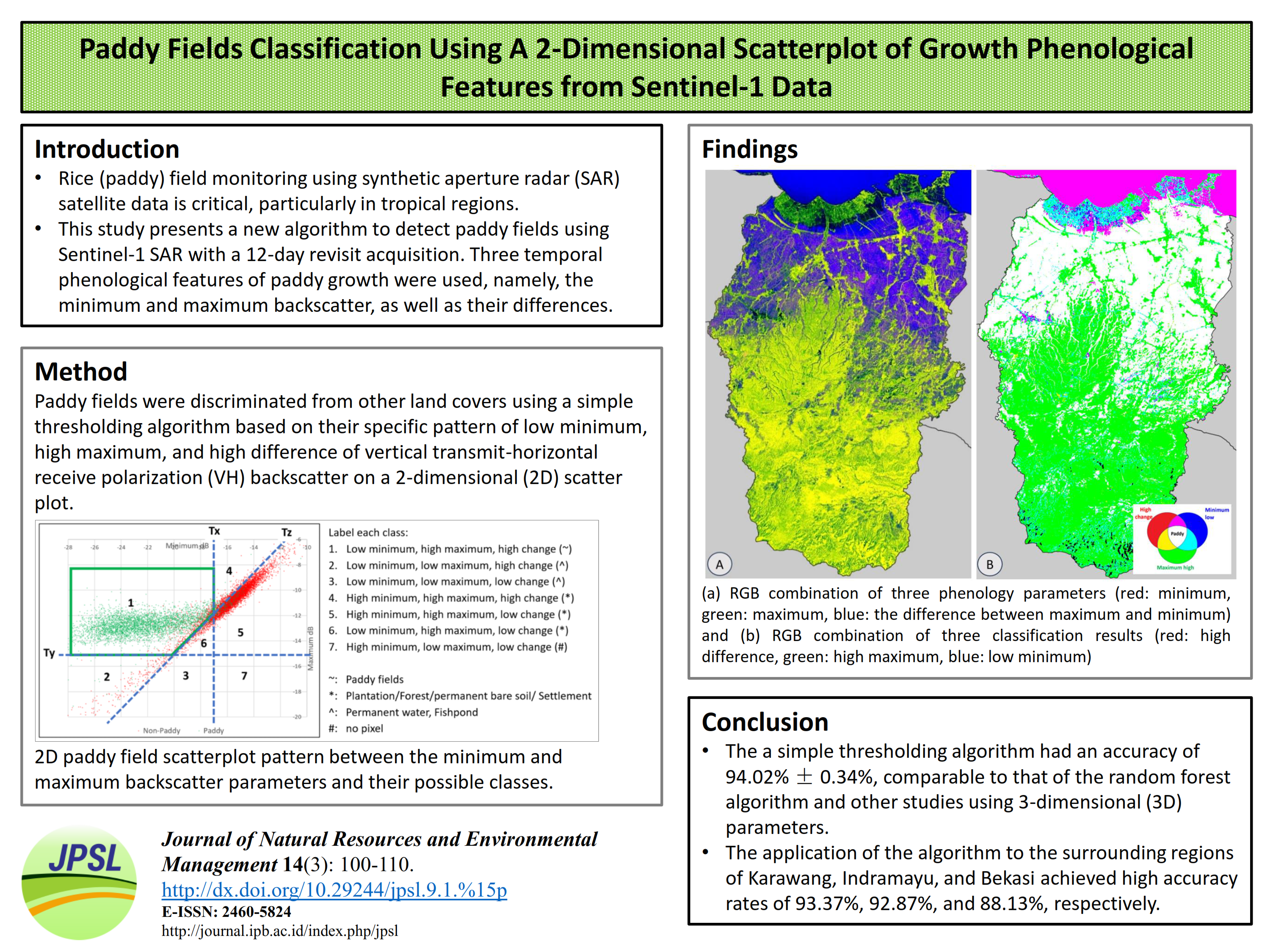
Rice plays an essential role in ensuring the food security of Indonesia. Hence, rice (paddy) field monitoring using synthetic aperture radar (SAR) satellite data is critical, particularly in tropical regions. This study presents a new algorithm to detect paddy fields in Subang, West Java, using Sentinel-1 SAR with a 12-day revisit acquisition. Three temporal phenological features of paddy growth were used, namely, the minimum and maximum backscatter, as well as their differences. Paddy fields were discriminated from other land covers using a simple thresholding algorithm based on their specific pattern of low minimum, high maximum, and high difference of vertical transmithorizontal receive polarization (VH) backscatter on a 2-dimensional (2D) scatter plot. The results showed that the proposed algorithm had an accuracy of 94.02%, comparable to that of the random forest algorithm and other studies using 3-dimensional (3D) parameters. The proposed algorithm reduces the dimensionality from 3D to 2D and is practical for mapping and monitoring paddy fields. In this context, the application of the algorithm to the surrounding regions of Karawang, Indramayu, and Bekasi achieved high accuracy rates of 93.37%, 92.87%, and 88.13%, respectively.
Full text article
References
Andersen HE. 2019. Chapter 7: Sampling Designs for SAR-Assisted Forest Biomass Surveys. In: The SAR Handbook, Comprehensive Methodologies for Forest Monitoring and Biomass Estimation. National Space Science and Technology Center. doi:10.25966/nr2c-s697.
BPS-Statistics Indonesia. 2019. Subang in Figure 2019. BPS Statistics of Subang Regency. Subang.
Dey S, Bhogapurapu N, Bhattacharya A, Mandal D, Lopez-Sanchez JM, McNairn H, Frery AC. 2021. Rice phenology mapping using novel target characterization parameters from polarimetric SAR data. Int J Remote Sens. 42(14):5515–5539. doi:10.1080/01431161.2021.1921876. DOI: https://doi.org/10.1080/01431161.2021.1921876
Dong J, Xiao X. 2016. Evolution of regional to global paddy rice mapping methods: A review. ISPRS J Photogramm Remote Sens. 119:214–227. doi:10.1016/j.isprsjprs.2016.05.010. DOI: https://doi.org/10.1016/j.isprsjprs.2016.05.010
Dutschmann T-M, Kinzel L, ter Laak A, Baumann K. 2023. Large-scale evaluation of k-fold cross-validation ensembles for uncertainty estimation. J Cheminform. 15(1):49. doi:10.1186/s13321-023-00709-9. DOI: https://doi.org/10.1186/s13321-023-00709-9
Filipponi F. 2019. Sentinel-1 GRD Preprocessing Workflow. International Electronic Conference on Remote Sensing. Vol. 18. MDPI AG. p. 1–4. DOI: https://doi.org/10.3390/ECRS-3-06201
Foody GM. 2023. Challenges in the real world use of classification accuracy metrics: From recall and precision to the Matthews correlation coefficient. PLoS One. 18(10 October):1–27. doi:10.1371/journal.pone.0291908. DOI: https://doi.org/10.1371/journal.pone.0291908
Fu W, Ma J, Chen P, Chen F. 2019. Chapter Remote Sensing Satellites for Digital Earth. In: Manual of Digital Earth. Springer Singapore. p. 55–123. DOI: https://doi.org/10.1007/978-981-32-9915-3_3
Google Developers. 2023. Sentinel-1 Algorithms. [accessed 2023 May 1]. https://developers.google.com/earth-engine/guides/sentinel1.
Indonesia. 2009. Law No.41 2009 concerning Protection of Sustainable Food Agricultural Land. Indonesian State Sheet 2009, No. 149. State Secretariat of The Republic of Indonesia. Jakarta.
Indonesia. 2011. Government Regulation of the Republic of Indonesia Number 1 of 2011 concerning Determination and Transfer of Functions of Sustainable Food Agriculture Land. Indonesian State Sheet 2011, No. 2. State Secretariat of The Republic of Indonesia. Jakarta.
Indonesia. 2018. Determination of 2018 National Rice Field Standards. Geospatial Information Agency (BIG). [accessed 2023 May 1]. https://onemap.big.go.id/DigitalSignature.
Kustiyo, Purwanto J, Wijaya A, Roswintiarti O. 2018. A Statistical Approach for Cloud Free Mosaic of Landsat-8 Imageries. Asian Conference on Remote Sensing Proceedings. 39-th Asian Conf Remote Sens. 2018:2111–2116.
Kustiyo, Rokhmatuloh, Saputro AH, Kushardono D. 2019. Developing the temporal composite of Sentinel-1 SAR data to identify paddy field area in Subang , West Java. In: Proceedings of spie, Sixth International Symposium on LAPAN-IPB Satellite. doi:10.1117/12.2540833. DOI: https://doi.org/10.1117/12.2540833
Leroy B, Delsol R, Hugueny B, Meynard CN, Barhoumi C, Barbet-Massin M, Bellard C. 2018. Without quality presence-absence data, discrimination metrics such as TSS can be misleading measures of model performance. J Biogeogr. 45(9):1994–2002. doi:10.1111/jbi.13402Citations. DOI: https://doi.org/10.1111/jbi.13402
Lestari AI, Kushardono D. 2019. The use of C-Band Synthetic Aperture Radar Satellite Data for Rice Plant Growth Phase Identification. Int J Remote Sens Earth Sci. 16(1):31–44. doi:10.30536/j.ijreses.2019.v16.a3171. DOI: https://doi.org/10.30536/j.ijreses.2019.v16.a3171
Park Seonyoung, Im J, Park Seohui, Yoo C, Han H, Rhee J. 2018. Classification and mapping of paddy rice by combining Landsat and SAR time series data. Remote Sens. 10(3). doi:10.3390/rs10030447. DOI: https://doi.org/10.3390/rs10030447
Suryono H, Kuswanto H, Iriawan N. 2022. Two-Phase Stratified Random Forest for Paddy Growth Phase Classification: A Case of Imbalanced Data. Sustainability. 14(22). doi:10.3390/su142215252. DOI: https://doi.org/10.3390/su142215252
Vincent P, Johnsen H, Piantanida R, Poullaouec J, Hajduch G. 2018. Sentinel-1 Sentinel-1 Product Specification. [ESA] European Space Agency. [accessed 2023 May 1]. https://sentinel.esa.int/documents/247904/1877131/Sentinel-1-Product-Specification.
Vollrath A, Mullissa A, Reiche J. 2020. Angular-based radiometric slope correction for Sentinel-1 on google earth engine. Remote Sens. 12(11). doi: 10.3390/rs12111867. DOI: https://doi.org/10.3390/rs12111867
Xu L, Zhang H, Wang C, Wei S, Zhang B, Wu F, Tang Y. 2021. Paddy rice mapping in thailand using time-series sentinel-1 data and deep learning model. Remote Sens. 13(19). doi: 10.3390/rs13193994. DOI: https://doi.org/10.3390/rs13193994
Yommy AS, Liu R, Wu AS. 2015. SAR Image Despeckling Using Refined Lee Filter. 7th International Conference on Intelligent Human-Machine Systems and Cybernetics. Vol. 2. p. 260–265. DOI: https://doi.org/10.1109/IHMSC.2015.236
Zhao R, Li Y, Ma M. 2021. Mapping paddy rice with satellite remote sensing: A review. Sustain. 13(2):1–20. doi:10.3390/su13020503. DOI: https://doi.org/10.3390/su13020503
Authors
Authors who publish with this journal agree to the following terms:
- Authors retain copyright and grant the journal right of first publication with the work simultaneously licensed under a Creative Commons Attribution License that allows others to share the work with an acknowledgement of the work's authorship and initial publication in this journal.
- Authors are able to enter into separate, additional contractual arrangements for the non-exclusive distribution of the journal's published version of the work (e.g., post it to an institutional repository or publish it in a book), with an acknowledgement of its initial publication in this journal.
- Authors are permitted and encouraged to post their work online (e.g., in institutional repositories or on their website) prior to and during the submission process, as it can lead to productive exchanges, as well as earlier and greater citation of published work (See The Effect of Open Access).
Article Details
How to Cite


