
Enhancing Performance Production Forest Inventory in Java Using LiDAR Technology
Article Sidebar
-
Forest, Resorces, Inventory, Technology, LiDAR
Abstract
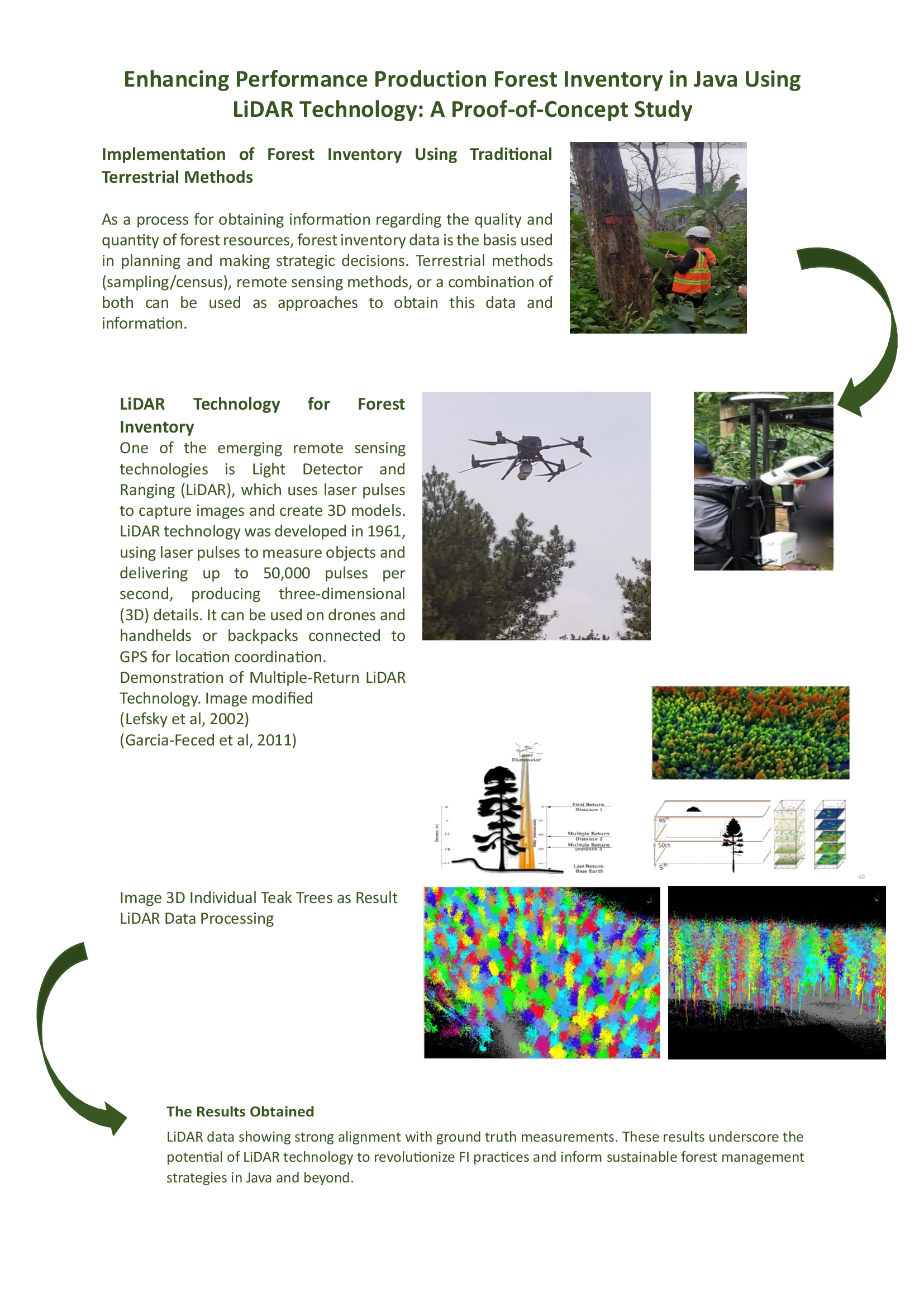
Forest inventory (FI) is an essential process for assessing the quality and quantity of forest resources, forming the foundation for strategic planning and sustainable management. Terrestrial methods (sampling / census), remote sensing methods, or a combination of these can be used to obtain this data and information. This study explores the application of LiDAR technology to improve forest inventory practices in plantation forests (teak and pine) in Java, Indonesia. LiDAR sensors, deployed via drones and handheld devices, were tested in several Perum Perhutani Forest Management Unit compartments, which were the locations of proof of concept (PoC). PoC is a testing process to prove the feasibility of a concept or methodology before it is implemented. The results showed that LiDAR-based inventories provide superior accuracy compared to traditional methods, with data showing strong alignment with ground-truth measurements. These results underscore the potential of LiDAR technology to revolutionize FI practices and inform sustainable forest management strategies in Java and beyond. The use of this technology in natural forests where the variety of tree species is more diverse certainly requires further study.
Full text article
References
Corte, A. P. D., Souza, D. V., Rex, F. E., Sanquetta, C. R., Mohan, M., Silva, C. A., Zambrano, A. M. A., Prata, G., de Almeida, D.R.A, Trautenmüller, J. W., Klauberg, C., de Moraes, A., Sanquetta, M. N., Wilkinson, B., Broadbent, E. N. 2020. Forest Inventory with High-density UAV-Lidar: Machine Learning Approaches for Predicting Individual Tree Attributes. Computers and Electronics in Agriculture Vol 179; 1-5. DOI: https://doi.org/10.1016/j.compag.2020.105815
Duncanson, L.I., Cook, B.D., Hurtt, G.C., Dubayah, R.O., 2014. An efficient, Multi-Layered Crown Delineation Algorithm for Mapping Individual Tree Structure Across Multiple Ecosystems. Remote Sensing Environment, 154; 6-9 DOI: https://doi.org/10.1016/j.rse.2013.07.044
Kementerian Lingkungan Hidup dan Kehutanan (LHK). 2021. Peraturan Menteri Lingkungan Hidup dan Kehutanan (LHK) No. 7 Tahun 2021; 31-39
Ko, C., Lee, S., Yim J., Kim D., Kang J. 2021. Comparison of Forest Inventory Methods at Plot-Level between a Backpack Personal Laser Scanning (BPLS) and Conventional Equipment in Jeju Island, South Korea. Forests 2021, 12; 1-5. DOI: https://doi.org/10.3390/f12030308
Lim, K., Treitz, P., Wulder, M., St-Onge, B., Flood, M., 2003. LiDAR Remote Sensing of Forest Structure. Progress in Physical Geogrphy. 27; 101-105. DOI: https://doi.org/10.1191/0309133303pp360ra
Lopez-Amoedo, A., Silvosa, M.R., Lago, M.B., Lorenzo, H., Acuna-Alonso, C., Alvarez, X. 2023. Weight Estimation Models for Commercial Pinus Radiata Wood in Small Felling Stands Based on UAV-LiDAR Data. Trees, Forest and People, 14; 1-9. DOI: https://doi.org/10.1016/j.tfp.2023.100436
Proudman, A., Ramezani, M., Digurmati, S.T., Chebrolu, N., Fallon, M. 2022. Towards Real-Time Forest Inventory Using Handheld LiDAR. Robotics and Autonomous Systems, 157; 1-5 DOI: https://doi.org/10.1016/j.robot.2022.104240
Scheeres, J., de Jong, J., Brede, B., Brancalion, P.H.S., Brodbent, E.N., Zambrano, A.M.A., Gorgens, E.B., Silva, C.A., Valbuena, R., Molin, P., Strak, S., Rodrigues, R.R., Santoro, G.B., Resende, A.F., de Almeida, C.T., de Almeida, D.R.A. 2023. Distinguishing Forest Types in Restored Tropical Landscapes with UAV-borne LIDAR. Remote Sensing of Environment, 290; 2-5. DOI: https://doi.org/10.1016/j.rse.2023.113533
Authors
Authors who publish with this journal agree to the following terms:
- Authors retain copyright and grant the journal right of first publication with the work simultaneously licensed under a Creative Commons Attribution License that allows others to share the work with an acknowledgement of the work's authorship and initial publication in this journal.
- Authors are able to enter into separate, additional contractual arrangements for the non-exclusive distribution of the journal's published version of the work (e.g., post it to an institutional repository or publish it in a book), with an acknowledgement of its initial publication in this journal.
- Authors are permitted and encouraged to post their work online (e.g., in institutional repositories or on their website) prior to and during the submission process, as it can lead to productive exchanges, as well as earlier and greater citation of published work (See The Effect of Open Access).
Article Details
How to Cite


