
Landslides Hazard Assessment Using Soil Physics Approaches as a Determinant Factor on Agricultural Land in Hilly Area
Article Sidebar
-
GIS, Land Degradation, Hazard Mitigation
Abstract
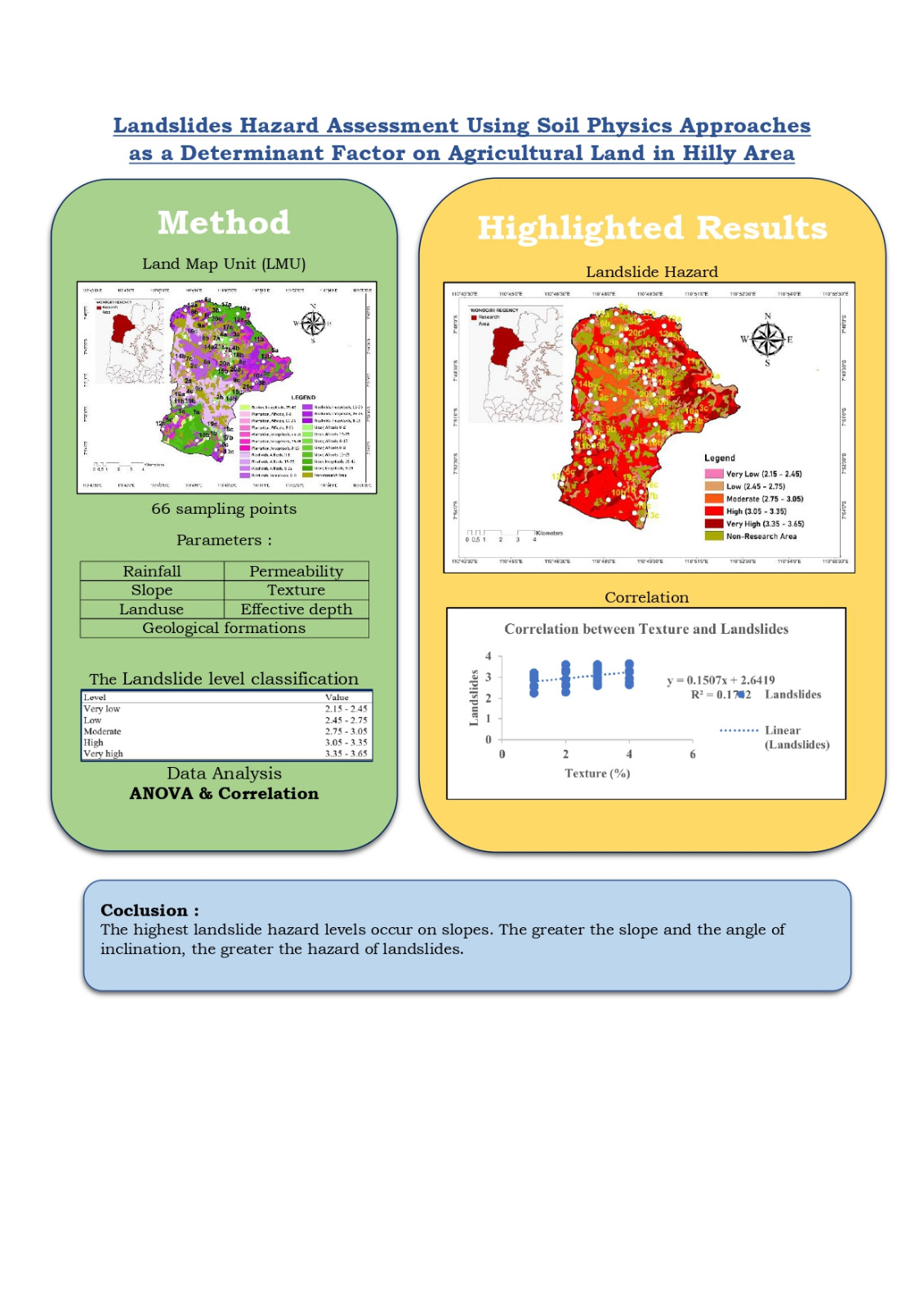
Landslides are natural disasters that most often occur in hilly areas, one of which is in the Manyaran District, and are caused by land use, slope, and rainfall. This study aimed to assess the level of landslides on several slopes and determine the soil characteristics that most determine the level of landslide vulnerability to formulate an appropriate strategy for hilly land management. The sampling points used land map units (LMU) overlaid on thematic maps (land use, soil type, and slope), and were divided into 22 LMUs with three repeats for each LMU. The landslide level was calculated using a cumulative weight score. It was grouped based on the interval formula and modifications to the addition of permeability and soil texture parameters, while the determinants were analyzed using ANOVA and Pearson’s correlation. The results showed that the area was not very low (133.2 ha), low (1,015.33 ha), moderate (1,205.46 ha), high (3,248.48 ha), or very high
(734.1 ha). The highest landslide hazard was on steep land (25–45%), and the determining factors were permeability and texture. The steeper the slope and the higher the permeability and soil texture values, the higher the landslide. The recommended landslide mitigation strategies are terracing and minimum tillage on agricultural land. Research on the level of landslides and information on determinant soil characteristics helps stakeholders formulate policies and manage agricultural land on hilly agricultural land.
Full text article
References
Annugerah A, Astuti IF, Kridalaksana AH. Sistem Informasi Geografis Berbasis Web Pemetaan Lokasi Toko Oleh-Oleh Khas Samarinda. Informatika Mulawarman : Jurnal Ilmiah Ilmu Komputer. 2016;11(2):43. doi:10.30872/jim.v11i2.213 DOI: https://doi.org/10.30872/jim.v11i2.213
Ba Q, Chen Y, Deng S, Yang J, Li H. A comparison of slope units and grid cells as mapping units for landslide susceptibility assessment. Earth Science Informatics. 2018;11(3):373–388. doi:10.1007/s12145-018-0335-9 DOI: https://doi.org/10.1007/s12145-018-0335-9
Calò F, Ardizzone F, Castaldo R, Lollino P, Tizzani P, Guzzetti F, Lanari R, Angeli MG, Pontoni F, Manunta M. Enhanced landslide investigations through advanced DInSAR techniques: The Ivancich case study, Assisi, Italy. Remote Sensing of Environment. 2014;142:69–82. http://dx.doi.org/10.1016/j.rse.2013.11.003. doi:10.1016/j.rse.2013.11.003 DOI: https://doi.org/10.1016/j.rse.2013.11.003
Çellek S. Effect of the slope angle and its classification on landslides. Himalayan Geology. 2022;43(1):85–95.
Choi KY, Cheung RWM. Landslide disaster prevention and mitigation through works in Hong Kong. Journal of Rock Mechanics and Geotechnical Engineering. 2013;5(5):354–365. http://dx.doi.org/10.1016/j.jrmge.2013.07.007. doi:10.1016/j.jrmge.2013.07.007 DOI: https://doi.org/10.1016/j.jrmge.2013.07.007
Darmawan W, Suprayogi A, Firdaus HS, Storie DM. Analisis Penentuan Zona Kerentanan Gerakan Tanah Dengan Metode Storie (Studi Kasus Kabupaten Wonogiri). Jurnal Geodesi Undip. 2018;7(4):47–54.
Hairiah K, Widianto W, Suprayogo D, Van Noordwijk M. Tree roots anchoring and binding soil: Reducing landslide risk in Indonesian agroforestry. Land. 2020;9(8):1–19. doi:10.3390/LAND9080256 DOI: https://doi.org/10.3390/land9080256
Hardianto A, Winardi D, Rusdiana DD, Putri ACE, Ananda F, Devitasari, Djarwoatmodjo FS, Yustika F, Gustav F. Pemanfaatan Informasi Spasial Berbasis SIG untuk Pemetaan Tingkat Kerawanan Longsor di Kabupaten Bandung Barat, Jawa Barat. Jurnal Geosains dan Remote Sensing. 2020;1(1):23–31. doi:10.23960/jgrs.2020.v1i1.16 DOI: https://doi.org/10.23960/jgrs.2020.v1i1.16
Haribulan R, Gosal PH, Karongkong HH. Kajian Kerentanan Fisik Bencana Longsor Di Kecamatan Tomohon Utara. Spasial. 2019;6(3):714–724.
Haque U, Paula F, Devoli G, Pilz J, Zhao B, Khaloua A, Wilopo W, Andersen P, Lu P, Lee J, et al. Science of the Total Environment The human cost of global warming : Deadly landslides and their triggers ( 1995 – 2014 ). Science of the Total Environment. 2019;682:673–684. https://doi.org/10.1016/j.scitotenv.2019.03.415. doi:10.1016/j.scitotenv.2019.03.415 DOI: https://doi.org/10.1016/j.scitotenv.2019.03.415
Harto MFD, Rachman A, L PR, Aisyah M, W HP, Abigail N, R FN, Utama W. Pemetaan Daerah Rawan Longsor Dengan Menggunakan Sistem Informasi Geografis Studi Kasus Kabupaten Bondowoso. Jurnal Geosaintek. 2017;3(3):161. doi:10.12962/j25023659.v3i3.3214 DOI: https://doi.org/10.12962/j25023659.v3i3.3214
Hemasinghe H, Rangali RSS, Deshapriya NL, Samarakoon L. Landslide susceptibility mapping using logistic regression model (a case study in Badulla District, Sri Lanka). Procedia Engineering. 2018;212:1046–1053. https://doi.org/10.1016/j.proeng.2018.01.135. doi:10.1016/j.proeng.2018.01.135 DOI: https://doi.org/10.1016/j.proeng.2018.01.135
Isnaini R. Analisis Bencana Tanah Longsor di Wilayah Provinsi Jawa Tengah. Islamic Management and Empowerment Journal. 2019;1(2):143–160. doi:10.18326/imej.v1i2.143-160 DOI: https://doi.org/10.18326/imej.v1i2.143-160
Wasowski J, Bovenga F. Remote Sensing of Landslide Motion with Emphasis on Satellite Multitemporal Interferometry Applications: An Overview. In: Landslide Hazards, Risks, and Disasters. 2015. p. 345–403. doi:10.1016/B978-0-12-396452-6.00011-2 DOI: https://doi.org/10.1016/B978-0-12-396452-6.00011-2
Kumar Rai P, Mohan K, Kumra VK. Landslide Hazard and Its Mapping Using Remote Sensing and Gis. Journal of Scientific Research. 2014;58(August 2019):1–13.
Lacroix P, Dehecq A, Taipe E. Irrigation-triggered landslides in a Peruvian desert caused by modern intensive farming. Nature Geoscience. 2020;13:1–5. doi:10.1038/s41561-019-0500-x DOI: https://doi.org/10.1038/s41561-019-0500-x
Lollino G, Manconi A, Clague J, Shan W, Chiarle M. Engineering geology for society and territory – Volume 1: Climate change and engineering geology. Engineering Geology for Society and Territory - Volume 1: Climate Change and Engineering Geology. 2015;(January):1–572. doi:10.1007/978-3-319-09300-0 DOI: https://doi.org/10.1007/978-3-319-09300-0
Lu CY, Tang CL, Chan YC, Hu JC, Chi CC. Forecasting landslide hazard by the 3D discrete element method: A case study of the unstable slope in the Lushan hot spring district, central Taiwan. Engineering Geology. 2014;183:14–30. http://dx.doi.org/10.1016/j.enggeo.2014.09.007. doi:10.1016/j.enggeo.2014.09.007 DOI: https://doi.org/10.1016/j.enggeo.2014.09.007
Lupiano V, Rago V, Terranova OG, Iovine G. Landslide inventory and main geomorphological features affecting slope stability in the Picentino river basin (Campania, southern Italy). Journal of Maps. 2019;15(2):131–141. doi:10.1080/17445647.2018.1563836 DOI: https://doi.org/10.1080/17445647.2018.1563836
Meng X, Jordan CJ, Novellino A, Dijkstra T. Investigating slow-moving landslides in the Zhouqu region of China using InSAR time series Investigating slow-moving landslides in the Zhouqu region of China using InSAR time-series. 2019:0–30.
Naryanto HS, Soewandita H, Ganesha D, Prawiradisastra F, Kristijono A. Analisis Penyebab Kejadian dan Evaluasi Bencana Tanah Longsor di Desa Banaran, Kecamatan Pulung, Kabupaten Ponorogo, Provinsi Jawa Timur Tanggal 1 April 2017. Jurnal Ilmu Lingkungan. 2019;17(2):272. doi:10.14710/jil.17.2.272-282 DOI: https://doi.org/10.14710/jil.17.2.272-282
Panchal S, Shrivastava AK. Landslide hazard assessment using analytic hierarchy process (AHP): A case study of National Highway 5 in India. Ain Shams Engineering Journal. 2022;13(3):101626. https://doi.org/10.1016/j.asej.2021.10.021. doi:10.1016/j.asej.2021.10.021 DOI: https://doi.org/10.1016/j.asej.2021.10.021
Persichillo MG, Bordoni M, Meisina C. The role of land use changes in the distribution of shallow landslides. Science of the Total Environment. 2017;574:924–937. doi:10.1016/j.scitotenv.2016.09.125 DOI: https://doi.org/10.1016/j.scitotenv.2016.09.125
Novellino A, Confuorto P, Di Martire D, Calcaterra D, Ramondini M, Infante D. Monitoring of remedial works performance on landslide-affected areas through ground- and satellite-based techniques. Catena. 2019;178. doi:10.1016/j.catena.2019.03.005 DOI: https://doi.org/10.1016/j.catena.2019.03.005
Rosi A, Tofani V, Tanteri L, Tacconi Stefanelli C, Agostini A, Catani F, Casagli N. The new landslide inventory of Tuscany (Italy) updated with PS-InSAR: geomorphological features and landslide distribution. Landslides. 2018;15(1):5–19. doi:10.1007/s10346-017-0861-4 DOI: https://doi.org/10.1007/s10346-017-0861-4
Salimah A. Slope stability analysis for landslide mitigation in Satui, Tanah Bumbu, South Kalimantan. IOP Conference Series: Earth and Environmental Science. 2021;708(1). doi:10.1088/1755-1315/708/1/012022 DOI: https://doi.org/10.1088/1755-1315/708/1/012022
Setiawan MA, Sara FH, Christanto N, Sartohadi J, Samodra G, Widicahyono A, Ardiana N, Widiyati CN, Astuti EM, Martha GK, et al. Sustainability of three modified soil conservation methods in agriculture area. IOP Conference Series: Earth and Environmental Science. 2018;148(1). doi:10.1088/1755-1315/148/1/012018 DOI: https://doi.org/10.1088/1755-1315/148/1/012018
Shahabi H, Ahmad BB, Khezri S. Evaluation and comparison of bivariate and multivariate statistical methods for landslide susceptibility mapping (case study: Zab basin). Arabian Journal of Geosciences. 2013;6(10):3885–3907. doi:10.1007/s12517-012-0650-2 DOI: https://doi.org/10.1007/s12517-012-0650-2
Singh R, Umrao RK, Singh TN. Probabilistic analysis of slope in Amiyan landslide area, Uttarakhand. Geomatics, Natural Hazards and Risk. 2013;4(1):13–29. doi:10.1080/19475705.2012.661796 DOI: https://doi.org/10.1080/19475705.2012.661796
Kumar Rai P, Mohan K, Kumra VK. Landslide Hazard and Its Mapping Using Remote Sensing and Gis. Journal of Scientific Research. 2014;58(August 2019):1–13.
Torkashvand AM, Irani A, Sorur J. The preparation of landslide map by Landslide Numerical Risk Factor (LNRF) model and Geographic Information System (GIS). Egyptian Journal of Remote Sensing and Space Science. 2014;17(2):159–170. http://dx.doi.org/10.1016/j.ejrs.2014.08.001. doi:10.1016/j.ejrs.2014.08.001 DOI: https://doi.org/10.1016/j.ejrs.2014.08.001
Muhammadi R, Rayes ML, Nita I. Penerapan Sistem Informasi Geografi Dalam Pendugaan Sebaran Daerah Rawan Longsor Di Kecamatan Ngargoyoso, Kabupaten Karanganyar. Tanah dan Sumberdaya Lahan. 2019;6(1):1145–1156. doi:10.21776/ub.jtsl.2019.00
Umaroh RA, Ritohardoyo S. Strategi penghidupan masyarakat korban bencana tanah longsor (kasus: Kecamatan Banjarmangu dan Kecamatan Karangkobar, Kabupaten Banjarnegara). Jurnal Bumi Indonesia. 2016;5(4):1–8.
Sitorus SRP, Pravitasari AE. Land Degradation and Landslide in Indonesia Main Function of Land. Sumatra Journal of Disaster, Geography and Geography Education. 2017;1(2):61–71. http://sjdgge.ppj.unp.ac.id
Wang XG, Wang W, Huang D, Yong B, Chen X. Modifying SEBAL model based on the trapezoidal relationship between land surface temperature and vegetation index for actual evapotranspiration estimation. Remote Sensing. 2014;6(7):5909–5937. doi:10.3390/rs6075909 DOI: https://doi.org/10.3390/rs6075909
Sitorus SRP, Pravitasari AE. Land Degradation and Landslide in Indonesia Main Function of Land. Sumatra Journal of Disaster, Geography and Geography Education. 2017;1(2):61–71. http://sjdgge.ppj.unp.ac.id DOI: https://doi.org/10.24036/sjdgge.v2i2.168
Duc D. Rainfall-triggered large landslides on 15 December 2005 in Van Canh District, Binh Dinh Province, Vietnam. Landslides. 2013;10. doi:10.1007/s10346-012-0362-4 DOI: https://doi.org/10.1007/s10346-012-0362-4
Authors
Authors who publish with this journal agree to the following terms:
- Authors retain copyright and grant the journal right of first publication with the work simultaneously licensed under a Creative Commons Attribution License that allows others to share the work with an acknowledgement of the work's authorship and initial publication in this journal.
- Authors are able to enter into separate, additional contractual arrangements for the non-exclusive distribution of the journal's published version of the work (e.g., post it to an institutional repository or publish it in a book), with an acknowledgement of its initial publication in this journal.
- Authors are permitted and encouraged to post their work online (e.g., in institutional repositories or on their website) prior to and during the submission process, as it can lead to productive exchanges, as well as earlier and greater citation of published work (See The Effect of Open Access).
Article Details
How to Cite


