
Analysis of the Carrying Capacity of Groundwater Availability and its Relation to Population Growth in Settlements of Colomadu District, Karanganyar Regency
Article Sidebar
-
water availability
Abstract
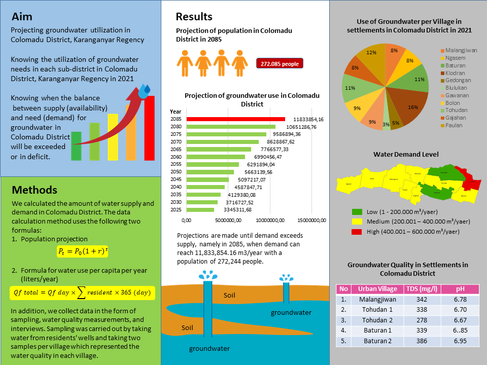
Colomadu District is an area on the outskirts of or around a city that is experiencing rapid development due to the local population’s interest in moving, causing an increase in population. The aim is to determine the projected use of groundwater in Colomadu District, Karanganyar Regency, to determine the use of groundwater needs in each village in Colomadu District, Karanganyar Regency in 2021, and to determine when the balance between supply (availability) and demand of groundwater in Colomadu District will be exceeded or in deficit. The research method used was data collection in the form of sampling, measuring water quality, and interviews. Sampling was carried out by collecting water from the residents' wells and taking as many as two samples per village, which represented the water quality in each village. The samples were collected by first drawing water from the well, then the prepared sample bottles were rinsed three times using sample water (well water), and the rinsed bottles were then filled with sample water. The projection of groundwater use in Colomadu District in 2025 is 3,345,311.68 m3 year-1; in 2030 is 3,716,727.52 m3 year-1; in 2035 is 4,129,380.08 m3 year-1; and in 2040 is 4,587,847.71 m3 year-1. Projections are made until demand exceeds supply, namely, in 2085, when demand can reach 11,833,854.16 m3 year-1 with a population of 272,244 people.
Full text article
References
Badan Pusat Statistik, 2018. Jenis Tanah Menurut Kecamatan di Kabupaten Karanganyar Tahun 2018. Karanganyar.
Badan Pusat Statistik, 2020. Banyaknya Hari Hujan (HR) dan Curah Hujan (MM) menurut Bulan dan Tempat Pengukuran di Kabupaten Karanganyar Tahun 2020. Karanganyar.
Bappeda, 2016. Peta Kemiringan Lereng Kabupaten Karanganyar. Karanganyar.
Dinas Kominfo Kabupaten Karanganyar, 2018. Profil Kabupaten Karanganyar Tahun 2018. Karanganyar.
Duan, H., Z. Deng, F. Deng, and D. Wang. 2016. Assessment of Groundwater Potential Based on Multicriteria Decision Making Model and Decision Tree Algorithms. Mathematical Problems in Engineering. 2016 : 1-11.
Febriarta, E. dan R. Oktama. 2020. Pemetaan daya dukung lingkungan berbasis jasa ekosistem penyedia pangan dan air bersih di Kota Pekalongan. Jurnal Ilmu Lingkungan. 18(2) : 283-289.
Kusumawardhani, N.P. 2020. Analysis of water carrying capacity for regional planning development in Malang Regency. JAUR (JOURNAL OF ARCHITECTURE AND URBANISM RESEARCH). 3(2): 166-174.
Li, M., Y. Xu, Q. Fu, V.P. Singh, D. Liu, and T. Li. 2020. Efficient irrigation water allocation and its impact on agricultural sustainability and water scarcity under uncertainty. Journal of Hydrology. 586 : 1-12.
Mandal, U., S. Sahoo, S.B. Munusamy, A. Dhar, S.N. Panda, A. Kar, and P. Mishra. 2016. Delineation of Groundwater Potential Zones of Coastal Groundwater Basin Using Multi-Criteria Decision Making Technique. Water Resources Management. 30(12) : 4293–4310Nabi, G., M. Ali, S. Khan, and S. Kumar. 2019. The crisis of water shortage and pollution in Pakistan: risk to public health, biodiversity, and ecosystem. Environmental science and pollution research. 26(11) : 10443-10445.
Peraturan Menteri Kehutanan Republik Indonesia Nomor: P. 32/Menhut-Ii/2009 tentang Tata Cara Penyusunan Rencana Teknik Rehabilitasi Hutan dan Lahan Daerah Aliran Sungai (Rtkrhl-Das).
Permen PUPR No. 02/PRT/M/2013 Tahun 2013 tentang Pedoman Penyusunan Rencana Pengelolaan Sumber Daya Air.
Pradana, A.C., S. Soedwiwahjono, dan K. Nurhadi. 2021. Fenomena Perubahan Penggunaan Lahan Pertanian menjadi Perumahan: Studi Kasus Kawasan Peri-Urban Kecamatan Colomadu. Desa-Kota: Jurnal Perencanaan Wilayah, Kota, dan Permukiman. 3(1) : 24-35.
RAHMADHANI, P., & Priyana, Y. (2018). Kajian Ketersediaan Air Tanah Bebas Untuk Kebutuhan Domestik Di Kecamatan Colomadu Kabupaten Karanganyar (Doctoral dissertation, Universitas Muhammadiyah Surakarta).
Selvam, S., F.A. Dar, N.S. Magesh, C. Singaraja, S. Venkatramanan, and S.Y. Chung. 2016. Application of remote sensing and GIS for delineating groundwater recharge potential zones of Kovilpatti Municipality, Tamil Nadu using IF technique. Earth Science Informatics. 9(2) : 137-150.
Authors
Authors who publish with this journal agree to the following terms:
- Authors retain copyright and grant the journal right of first publication with the work simultaneously licensed under a Creative Commons Attribution License that allows others to share the work with an acknowledgement of the work's authorship and initial publication in this journal.
- Authors are able to enter into separate, additional contractual arrangements for the non-exclusive distribution of the journal's published version of the work (e.g., post it to an institutional repository or publish it in a book), with an acknowledgement of its initial publication in this journal.
- Authors are permitted and encouraged to post their work online (e.g., in institutional repositories or on their website) prior to and during the submission process, as it can lead to productive exchanges, as well as earlier and greater citation of published work (See The Effect of Open Access).
Article Details
How to Cite


