
Detecting Flood Inundation using a Multi-Threshold Overlay Approach and Its Relationship with the Land Cover in Pontianak
Article Sidebar
-
flood-prone, land cover, multi-threshold, google earth engine
Abstract
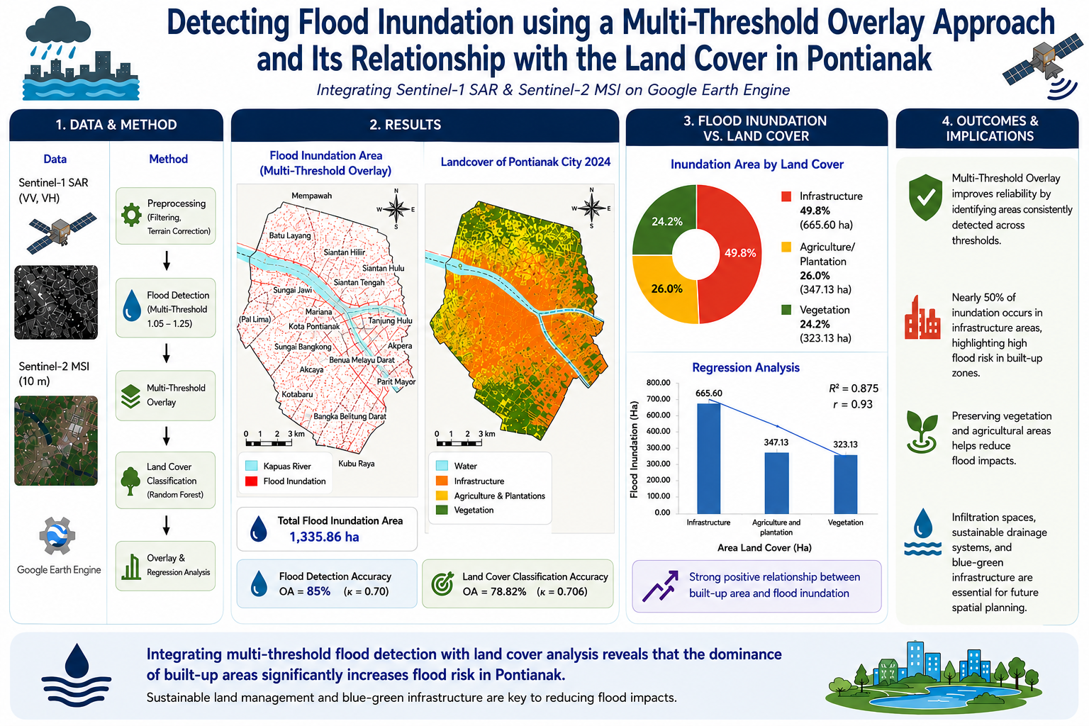
Pontianak is a lowland area prone to flooding driven by hydrological factors, topographical conditions, and land cover changes. This study analyzed flood inundation using a Multi-Threshold Overlay approach based on Sentinel-1 SAR imagery and examined its relationship with land cover classified from Sentinel-2 MSI imagery using the Random Forest algorithm on the Google Earth
Engine. This study assumes that the Multi-threshold Overlay approach improves flood detection reliability by identifying areas consistently detected across multiple threshold values. The relationship between flood inundation and land cover was analyzed using spatial overlay and regression analysis. The results showed that the land cover classification achieved an Overall Accuracy of 78.82% (κ = 0.706), while the flood inundation detection attained an Overall Accuracy of 85% (κ = 0.70). The Multi-Threshold Overlay approach identified 1,335.86 ha of flood inundation and generated consistent inundation areas across all threshold values (1.05–1.25). The consistent identification of inundated areas across multiple threshold values suggests that integrating threshold values can improve the reliability of flood inundation mapping. Overlay analysis indicated that infrastructure areas accounted for 49.8% of the total inundated area, followed by agricultural/plantation areas (26.0%) and vegetation cover (24.2%). Regression analysis further confirmed a strong positive relationship between land cover and flood inundation extent (R² = 0.875; r = 0.93). These findings suggest that the dominance of built-up areas increases the risk of flood inundation, highlighting the importance of infiltration space, sustainable drainage systems, and blue-green infrastructure in spatial planning.
Full text article
References
[1] E. Nurhidayati, “Konsep Blue-Green Infrastructure (BGI) Melalui Permeable Pavements Pedestrian dan Kolam Retensi untuk Mitigasi Genangan Banjir di Kota Pontianak,” vol. 19, no. 1, pp. 92–110, 2022, doi: https://doi.org/10.30659/jpsa.v19i1.18043.
[2] L. Xie and H. Zhao, “Correlation Between Flood Disaster and Topography: A Case Study of Zhaoqing City,” J. Nat. Disaster, vol. 22, no. 6, pp. 240–245, 2013.
[3] I. Arianti, M. Rafani, Wattini, N. Fitriani, Nizar, and B. Vatria, “Development of an Adaptive Drainage System for Flood Mitigation Using GIS,” Eur. J. Appl. Sci. Eng. Technol., vol. 2, no. 6, pp. 81–89, 2024, doi: 10.59324/ejaset.2024.2(6).07.
[4] F. I. Farhan and A. C. Adi, “Forecasting Flood Vulnerability in Pontianak using Multiple Linear Regression and Geospatial Information Systems (GIS),” Innov. Res. Informatics, vol. 5, no. 1, pp. 9–13, 2023, doi: 10.37058/innovatics.v5i1.6567.
[5] E. Nurhidayati, I. Buchori, and M. Mussadun, “Prediksi Perkembangan Lahan Permukiman Terhadap Kerentanan Bencana Banjir Dan Kebakaran Di Permukiman Tepian Sungai Kapuas Kota Pontianak,” Tataloka, vol. 18, no. 4, p. 249, 2016, doi: 10.14710/tataloka.18.4.249-260.
[6] T. I. Akukwe, “Determinants of Flooding in Port Harcourt Metropolis, Nigeria,” IOSR J. Humanit. Soc. Sci., vol. 19, no. 11, pp. 64–72, 2014, doi: 10.9790/0837-191186472.
[7] A. Akallouch, A. Al Mashoudi, M. Ziani, and R. Elhani, “GIS Application in Urban Flood Risk Analysis: Midar as a Case Study,” Open J. Ecol., vol. 14, no. 02, pp. 148–164, 2024, doi: 10.4236/oje.2024.142009.
[8] A. N. Saputra et al., “Analysis of Flood Inundation Mapping Using the Weighting Method in Urban Floods,” in IOP Conference Series: Earth and Environmental Science, 2023, vol. 1276, no. 1, doi: 10.1088/1755-1315/1276/1/012026.
[9] R. A. Kenranto, H. Hidayat, and F. Bioresita, “Analisis Genangan Banjir Terhadap Penutup Lahan di Wilayah Tangerang Menggunakan Data Citra Sentinel-1 dan Sentinel-2,” JGISE J. Geospatial Inf. Sci. Eng., vol. 7, no. 1, p. 14, 2024, doi: 10.22146/jgise.87579.
[10] L. Kumar and O. Mutanga, “Google Earth Engine Applications Since Inception: Usage, Trends, and Potential,” Remote Sens., vol. 10, pp. 1–15, 2018, doi: 10.3390/rs10101509.
[11] M. Azila, A. A. Damai, and A. M. Asbi, “Arahan Pemanfaatan Ruang Berbasis Mitigasi Bencana Banjir di Kecamatan Jatinegara, Jakarta Timur,” J. Planoearth, vol. 8, no. 2, pp. 47–53, 2023, [Online]. Available: https://repository.ipb.ac.id/handle/123456789/114177.
[12] B. Paramita and A. Matzarakis, “Urban Biometeorology of Tropical Climate: Af, Am, Aw, a Propensity of 34 Provincial Cities in Indonesia BT - Climate Change and Cooling Cities,” A. Cheshmehzangi, B.-J. He, A. Sharifi, and A. Matzarakis, Eds. Singapore: Springer Nature Singapore, 2023, pp. 283–296.
[13] Badan Pusat Statistik Kota Pontianak, “Kota Pontianak dalam Angka 2024 (Pontianak Municipality in Figures 2024),” Pontianak, 2024.
[14] R. B. Butar-Butar, “Bencana Banjir di Kota Pontianak Tahun 2004–2021,” IKIP-PGRI Pontianak, 2023.
[15] T. M. Lillesand, R. W. Kiefer, and J. W. Chipman, Remote sensing and image interpretation (7th ed.). Wiley, 2015.
[16] L. Breiman, Random Forest. 2001.
[17] M. G. Ngurawan, “Analisis Sebaran Spasial Genangan Banjir Dengan Data Sentinel-1 Menggunakan Google Earth Engine (Studi Kasus: Kalimantan Selatan),” Institut Teknologi Sepuluh Nopember, 2021.
[18] L. Lin et al., “Improvement and validation of NASA/MODIS NRT global flood mapping,” Remote Sens., vol. 11, no. 2, 2019, doi: 10.3390/rs11020205.
[19] R. G. Congalton, “A Review of Assessing the Accuracy of Classifications of Remotely Sensed Data,” Remote Sens. Environ., vol. 37, no. 1, pp. 35–46, 1991, doi: https://doi.org/10.1016/0034-4257(91)90048-B.
[20] N. C. I. Natun and Sumarlin, “Analisis Perbandingan Klasifikasi Supervised dan Unsupervised Citra Satelit Landsat untuk Pemetaan Penutupan Lahan Di Kabupaten Kupang,” J. Manaj. Inform. Jayakarta, vol. 5, no. 2, pp. 142–152, 2025, doi: https://doi.org/10.52362/jmijayakarta.v5i2.1812.
[21] P. Olofsson, G. M. Foodu, M. Herold, S. V Steman, C. E. Woodcock, and M. A. Wulder, “Good Practices for Estimating Area and Assessing Accuracy of Land Change,” Remote Sens. Environ., vol. 148, pp. 42–57, 2014, doi: https://doi.org/10.1016/j.rse.2014.02.015.
[22] O. Ahlqvist, “Overlay ( in GIS ) Provided for non-commercial research and educational use only . Not for reproduction , distribution or commercial use .,” Int. Encycl. Hum. Geogr., vol. 8, pp. 48–55, 2009, doi: 10.1016/B978-008044910-4.00487-9.
[23] G. Donchyts, J. Schellekens, H. Winsemius, E. Eisemann, and N. Van de Giesen, “Detecting Change in Large-Scale Earth Observation Data Using Unsupervised Methods,” Remote Sens., vol. 8, no. 2, p. 103, 2016, doi: https://doi.org/10.3390/rs8020103.
[24] D. C. Mason, S. L. Dance, and H. Cloke, “Toward improved urban flood detection using Sentinel-1: dependence of the ratio of post- to preflood double scattering cross sections on building orientation,” J. Appl. Remote Sens., vol. 17, 2023, doi: https://doi.org/10.1117/1.JRS.17.016507.
[25] R. Abdo and L. Ferro-Famil, “Polsar Analysis of Coherent and Diffuse Double-Bounce Scattering Occuring Within a Vegetated Medium,” Int. Geosci. Remote Sens. Symp., pp. 3865–3868, 2020, doi: https://doi.org/10.1109/IGARSS39084.2020.9324367.
[26] R. G. Congalton and K. Green, Assessing the Accuracy of Remotely Sensed Data: Principles and Practices, 2nd editio. Boca Raton: Lewis Publisher, 2009.
[27] J. R. Landis and G. G. Koch, “The Measurement of Observer Agreement for Categorical Data,” Biometrics, vol. 33, no. 1, pp. 159–174, 1977.
[28] F. Machado and L. R. Vestena, “Evolution of the Flood Mark and Built-up Areas in Flooded Lands in the City of Guarapuava, Paraná,” Rev. Geociências Do Nord., vol. 10, no. 1, pp. 537–550, 2024, doi: https://doi.org/10.21680/2447-3359.2024v10n1id34910.
[29] A. Malviya, A. Dwivedi, A. Manore, A. Bamniya, and A. Sinha, “A Conceptual Design Model to Groundwater Recharge in Dense Urban Area Roads,” Int. J. Innov. Technol. Explor. Eng., vol. 9, no. 7, pp. 751–755, 2020, doi: 10.35940/ijitee.g5480.059720.
[30] J. Choi and J. W. Harvey, “Relative Significance of Microtopography and Vegetation as Controls on Surface Water Flow on a Low-Gradient Floodplain,” Wetlands, vol. 34, no. 1, pp. 101–115, 2014, doi: https://doi.org/10.1007/S13157-013-0489-7.
[31] R. M. C. Alves, S. A. N. Lousada, J. Cabezas, and J. M. N. Gómez, “Urban Flooding Risk in Machico and Planning Its Territory as a Form of Prevention,” Geoinformatics Support Urban Polit. Dev. Civ. Eng., pp. 50–76, 2023, doi: https://doi.org/10.4018/978-1-6684-6449-6.ch003.
[32] X. Qin, Q. Shi, S. Member, D. Wang, and X. Su, “Inundation Impact on Croplands of 2020 Flood Event in Three Provinces of China,” IEEE J. Sel. Top. Appl. Earth Obs. Remote Sens., vol. 15, pp. 3179–3189, 2022, doi: 10.1109/JSTARS.2022.3161320.
[33] A. P. Monachese, M. T. Gómez-Villarino, J. López-Santiago, E. Sanz, A. F. Almeida-Ñauñay, and S. Zubelzu, “Challenges and Innovations in Urban Drainage Systems: Sustainable Drainage Systems Focus,” Water (Switzerland), vol. 17, no. 1, pp. 1–18, 2025, doi: 10.3390/w17010076.
[34] B. Kartiwa et al., “Polder system water management on non-tidal swamp area based on water balance analysis,” in IOP Conference Series: Earth and Environmental Science, 2021, vol. 648, no. 1, doi: https://doi.org/10.1088/1755-1315/648/1/012061.
Authors
Copyright (c) 2026 Boy Rangga; Hervian Handika Sugasta, Doddy Cahyadi Saputra

This work is licensed under a Creative Commons Attribution 4.0 International License.
Authors who publish with this journal agree to the following terms:
- Authors retain copyright and grant the journal right of first publication with the work simultaneously licensed under a Creative Commons Attribution License that allows others to share the work with an acknowledgement of the work's authorship and initial publication in this journal.
- Authors are able to enter into separate, additional contractual arrangements for the non-exclusive distribution of the journal's published version of the work (e.g., post it to an institutional repository or publish it in a book), with an acknowledgement of its initial publication in this journal.
- Authors are permitted and encouraged to post their work online (e.g., in institutional repositories or on their website) prior to and during the submission process, as it can lead to productive exchanges, as well as earlier and greater citation of published work (See The Effect of Open Access).
Article Details
How to Cite