
GIS Modelling for Assessing Flood Risk: A Case Study in Sumbermanjing Wetan District, Malang Regency, Indonesia
Article Sidebar
-
Flood, Risk assessment, Spatial analysis, Disaster management
Abstract
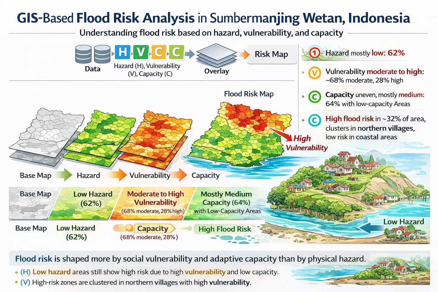
Flood hazard in rural Indonesia is a constant issue, yet detailed risk assessments at the sub-district level are still lacking. This study creates a GIS-based multi-index framework to assess flood risk in Sumbermanjing Wetan District, Malang Regency. It combines hazard, vulnerability, and capacity dimensions using spatial and socioeconomic data. The hazard assessment looks at land system
characteristics, average rainfall over the past decade, land cover, and topographic features from a 12-meter resolution ALOS PALSAR DEM. Vulnerability and capacity are based on demographic and institutional indicators. We normalized variables and combined them into composite indices, resulting in a flood risk map for the entire district. Low hazard conditions cover 62.00% of the study area. Most of the vulnerability is moderate (68.48%), while 28.24% of the area is classified as high vulnerability. Medium capacity levels account for 64.30%, but they are unevenly spread throughout the region. Additionally, 32.11% of the district falls into the high-risk category. The highest-risk zones are found in four villages: Argotirto, Harjokuncaran, Tegalrejo, and Sitiarjo. The results indicate that socioeconomic factors and limited options for adaptation, rather than the severity of physical hazards, drive this risk. Therefore, efforts to reduce flooding in rural areas should focus on building social resilience rather than solely relying on physical infrastructure. Immediate steps in these four villages should include improving healthcare access, increasing emergency preparedness, and creating alternative income sources. Even though this study does not validate hydrodynamic modeling, the framework provides practical and clear guidance for prioritizing disaster management in data-limited areas.
Full text article
References
1. Cea, L.; Costabile, P. Flood Risk in Urban Areas: Modelling, Management and Adaptation to Climate Change. A Review. Hydrology 2022, 9, 50. https://doi.org/10.3390/hydrology9030050 DOI: https://doi.org/10.3390/hydrology9030050
2. Alfieri, L.; Bisselink, B.; Dottori, F.; et al. Global projections of river flood risk in a warmer world. Earth’s Future 2017, 5, 171–182. https://doi.org/10.1002/2016EF000485 DOI: https://doi.org/10.1002/2016EF000485
3. Nguyen, H. D.; Nguyen, T. H. T.; Nguyen, Q. H.; Nguyen, T. G.; Dang, D. K.; Nguyen, Y. N.; Bui, T. H.; Nguyen, N. D.; Bui, Q. T.; Brecan, P.; Petrisor, A. I. Bottom-up Approach for Flood-Risk Management in Developing Countries: A Case Study in the Gianh River Watershed of Vietnam. Nat. Hazards 2023, 118 (3), 1933–1959. https://doi.org/10.1007/s11069-023-06098-4. DOI: https://doi.org/10.1007/s11069-023-06098-4
4. Ziwei, L.; Xiangling, T.; Liju, L.; Yanqi, C.; Xingming, W.; Dishan, Y. GIS-Based Risk Assessment of Flood Disaster in the Lijiang River Basin. Sci. Rep. 2023, 13 (1), 1–13. https://doi.org/10.1038/s41598-023-32829-5. DOI: https://doi.org/10.1038/s41598-023-32829-5
5. Baggio, T.; Martini, M.; Bettella, F.; D’Agostino, V. Debris Flow and Debris Flood Hazard Assessment in Mountain Catchments. Catena 2024, 245 (July). https://doi.org/10.1016/j.catena.2024.108338. DOI: https://doi.org/10.1016/j.catena.2024.108338
6. Paprotny, D.; Sebastian, A.; Morales-Nápoles, O.; Jonkman, S. N. Trends in Flood Losses in Europe over the Past 150 Years. Nat. Commun. 2018, 9 (1). https://doi.org/10.1038/s41467-018-04253-1. DOI: https://doi.org/10.1038/s41467-018-04253-1
7. Jongman, B.; Ward, P.J.; Aerts, J.C.J.H. Global exposure to river and coastal flooding: Long term trends and changes. Glob. Environ. Change 2012, 22, 823–835. https://doi.org/10.1016/j.gloenvcha.2012.07.004. DOI: https://doi.org/10.1016/j.gloenvcha.2012.07.004
8. Tanoue, M.; Hirabayashi, Y.; Ikeuchi, H. Global-Scale River Flood Vulnerability in the Last 50 Years. Sci. Rep. 2016, 6, 1–9. https://doi.org/10.1038/srep36021. DOI: https://doi.org/10.1038/srep36021
9. Ward, P. J.; Jongman, B.; Aerts, J. C. J. H.; Bates, P. D.; Botzen, W. J. W.; Diaz Loaiza, A.; Hallegatte, S.; Kind, J. M.; Kwadijk, J.; Scussolini, P.; Winsemius, H. C. A Global Framework for Future Costs and Benefits of River-Flood Protection in Urban Areas. Nat. Clim. Chang. 2017, 7 (9), 642–646. https://doi.org/10.1038/nclimate3350. DOI: https://doi.org/10.1038/nclimate3350
10. Stanton-Geddes, Z.; Vun, Y. J. Strengthening the Disaster Resilience of Indonesian Cities. Time to ACT Realiz. Indones. Urban Potential 2019, No. September, 161–171. https://doi.org/10.1596/978-1-4648-1389-4_spotlight1. DOI: https://doi.org/10.1596/978-1-4648-1389-4_Spotlight1
11. Varra, G.; Della Morte, R.; Tartaglia, M.; Fiduccia, A.; Zammuto, A.; Agostino, I.; Booth, C. A.; Quinn, N.; Lamond, J. E.; Cozzolino, L. Flood Susceptibility Assessment for Improving the Resilience Capacity of Railway Infrastructure Networks. Water (Switzerland) 2024, 16 (18). https://doi.org/10.3390/w16182592 DOI: https://doi.org/10.3390/w16182592
12. Güneralp, B.; Güneralp, İ.; Liu, Y. Changing Global Patterns of Urban Exposure to Flood and Drought Hazards. Glob. Environ. Chang. 2015, 31, 217–225. https://doi.org/10.1016/j.gloenvcha.2015.01.002. DOI: https://doi.org/10.1016/j.gloenvcha.2015.01.002
13. Tanim, A. H.; McRae, C. B.; Tavakol-Davani, H.; Goharian, E. Flood Detection in Urban Areas Using Satellite Imagery and Machine Learning. Water 2022, 14 (7), 1140. https://doi.org/10.3390/w14071140. DOI: https://doi.org/10.3390/w14071140
14. Dharmarathne, G.; Waduge, A. O.; Bogahawaththa, M.; Rathnayake, U.; Meddage, D. P. P. Adapting Cities to the Surge: A Comprehensive Review of Climate-Induced Urban Flooding. Results Eng. 2024, 22, 102123. https://doi.org/10.1016/j.rineng.2024.102123. DOI: https://doi.org/10.1016/j.rineng.2024.102123
15. Papathoma-Köhle, M. Vulnerability Curves vs. Vulnerability Indicators: Application of an Indicator-Based Methodology for Debris-Flow Hazards. Nat. Hazards Earth Syst. Sci. 2016, 16 (8), 1771–1790. https://doi.org/10.5194/nhess-16-1771-2016. DOI: https://doi.org/10.5194/nhess-16-1771-2016
16. Lendering, K. T.; Jonkman, S. N.; Kok, M. Effectiveness of Emergency Measures for Flood Prevention. J. Flood Risk Manag. 2016, 9 (4), 320–334. https://doi.org/10.1111/jfr3.12185. DOI: https://doi.org/10.1111/jfr3.12185
17. Chan, S. W.; Abid, S. K.; Sulaiman, N.; Nazir, U.; Azam, K. A Systematic Review of the Flood Vulnerability Using Geographic Information System. Heliyon 2022, 8 (3), e09075. https://doi.org/10.1016/j.heliyon.2022.e09075. DOI: https://doi.org/10.1016/j.heliyon.2022.e09075
18. Diriba, D.; Takele, T.; Karuppannan, S.; Husein, M. Flood Hazard Analysis and Risk Assessment Using Remote Sensing, GIS, and AHP Techniques: A Case Study of the Gidabo Watershed, Main Ethiopian Rift, Ethiopia. Geomatics, Nat. Hazards Risk 2024, 15 (1). https://doi.org/10.1080/19475705.2024.2361813. DOI: https://doi.org/10.1080/19475705.2024.2361813
19. Ariyani, D.; Purwanto, M. Y. J.; Sunarti, E.; Perdinan, P.; Juniati, A. T. Integrated Flood Hazard Assessment Using Multi-Criteria Analysis and Geospatial Modeling. J. Degrad. Min. Lands Manag. 2024, 11 (4), 6121–6134. https://doi.org/10.15243/jdmlm.2024.114.6121. DOI: https://doi.org/10.15243/jdmlm.2024.114.6121
20. Domeneghetti, A.; Carisi, F.; Castellarin, A.; Brath, A. Evolution of Flood Risk over Large Areas: Quantitative Assessment for the Po River. J. Hydrol. 2015, 527, 809–823. https://doi.org/10.1016/j.jhydrol.2015.05.043. DOI: https://doi.org/10.1016/j.jhydrol.2015.05.043
21. Pakati, S. S.; Shoko, C.; Dube, T. Integrated Flood Modelling and Risk Assessment in Urban Areas: A Review on Applications, Strengths, Limitations and Future Research Directions. J. Hydrol. Reg. Stud. 2025, 61, 102583. https://doi.org/10.1016/j.ejrh.2025.102583. DOI: https://doi.org/10.1016/j.ejrh.2025.102583
22. Lawrence, D. Uncertainty Introduced by Flood Frequency Analysis in Projections for Changes in Flood Magnitudes under a Future Climate in Norway. J. Hydrol. Reg. Stud. 2020, 28, 100675. https://doi.org/10.1016/j.ejrh.2020.100675. DOI: https://doi.org/10.1016/j.ejrh.2020.100675
23. Supratman, M.; Kusuma, M. S. B.; Cahyono, M.; Kuntoro, A. A. Flood Hazard Assessment Due to Changes in Land Use and Cover. Civ. Eng. J. 2024, 10 (12), 3874–3891. https://doi.org/10.28991/CEJ-2024-010-12-04. DOI: https://doi.org/10.28991/CEJ-2024-010-12-04
24. Mukherjee, J.; Chowdhury, A.; Ghosh, S. Enhancing Watershed Management Through Advanced Geospatial and Morphometric Approaches for Wainganga River Basin, Central India; 2025; pp 563–598. https://doi.org/10.1007/978-3-031-62376-9_25. DOI: https://doi.org/10.1007/978-3-031-62376-9_25
25. Alawiyah, A. M.; Harintaka, H. Identifikasi Genangan Banjir Di Wilayah DKI Jakarta Menggunakan Citra Satelit Sentinel-1. JGISE J. Geospatial Inf. Sci. Eng. 2021, 4 (2), 95. https://doi.org/10.22146/jgise.68353. DOI: https://doi.org/10.22146/jgise.68353
26. Arianti, I.; Rafani, M.; Wattini; Fitriani, N.; Nizar; Vatria, B. Development of an Adaptive Drainage System for Flood Mitigation Using GIS. Eur. J. Appl. Sci. Eng. Technol. 2024, 2 (6), 81–89. https://doi.org/10.59324/ejaset.2024.2(6).07. DOI: https://doi.org/10.59324/ejaset.2024.2(6).07
27. Handayani, W.; Fisher, M. R.; Rudiarto, I.; Sih Setyono, J.; Foley, D. Operationalizing Resilience: A Content Analysis of Flood Disaster Planning in Two Coastal Cities in Central Java, Indonesia. Int. J. Disaster Risk Reduct. 2019, 35, 101073. https://doi.org/10.1016/j.ijdrr.2019.101073. DOI: https://doi.org/10.1016/j.ijdrr.2019.101073
28. Badan Nasional Penanggulangan Bencana (BNPB). Peraturan Kepala Badan Nasional Penanggulangan Bencana Nomor 02 Tahun 2012 tentang Pedoman Umum Pengkajian Risiko Bencana. BNPB: Jakarta, Indonesia, 2012.
29. Ahmed, N.; Hoque, M. A.-A.; Howlader, N.; Pradhan, B. Flood Risk Assessment: Role of Mitigation Capacity in Spatial Flood Risk Mapping. Geocarto Int. 2022, 37 (25), 8394–8416. https://doi.org/10.1080/10106049.2021.2002422 DOI: https://doi.org/10.1080/10106049.2021.2002422
30. Khoeun, C.; Sok, T.; Chan, R.; Khe, S.; Ich, I.; Chan, K.; Oeurng, C. Assessing Flood Hazard Index Using Analytical Hierarchy Process (AHP) and Geographical Information System (GIS) in Stung Sen River Basin. IOP Conf. Ser. Earth Environ. Sci. 2022, 1091 (1). https://doi.org/10.1088/1755-1315/1091/1/012031. DOI: https://doi.org/10.1088/1755-1315/1091/1/012031
31. Baky, M. A. Al; Islam, M.; Paul, S. Flood Hazard, Vulnerability and Risk Assessment for Different Land Use Classes Using a Flow Model. Earth Syst. Environ. 2020, 4 (1), 225–244. https://doi.org/10.1007/s41748-019-00141-w. DOI: https://doi.org/10.1007/s41748-019-00141-w
32. Ouma, Y. O.; Tateishi, R. Urban Flood Vulnerability and Risk Mapping Using Integrated Multi-Parametric AHP and GIS: Methodological Overview and Case Study Assessment. Water (Switzerland) 2014, 6 (6), 1515–1545. https://doi.org/10.3390/w6061515 DOI: https://doi.org/10.3390/w6061515
33. Kelman, I.; Glantz, M. H. Analyzing the Sendai Framework for Disaster Risk Reduction. Int. J. Disaster Risk Sci. 2015, 6 (2), 105–106. https://doi.org/10.1007/s13753-015-0056-3. DOI: https://doi.org/10.1007/s13753-015-0056-3
34. Luu, C.; Von Meding, J.; Kanjanabootra, S. Assessing Flood Hazard Using Flood Marks and Analytic Hierarchy Process Approach: A Case Study for the 2013 Flood Event in Quang Nam, Vietnam. Nat. Hazards 2018, 90 (3), 1031–1050. https://doi.org/10.1007/s11069-017-3083-0. DOI: https://doi.org/10.1007/s11069-017-3083-0
35. Dung, N. B.; Long, N. Q.; Goyal, R.; An, D. T.; Minh, D. T. The Role of Factors Affecting Flood Hazard Zoning Using Analytical Hierarchy Process: A Review. Earth Syst. Environ. 2022, 6 (3), 697–713. https://doi.org/10.1007/s41748-021-00235-4. DOI: https://doi.org/10.1007/s41748-021-00235-4
36. BPS Kabupaten Malang. Kecamatan Sumbermanjing Wetan Dalam Angka 2024. 2024.
37. Pathak, S.; Panta, H. K.; Bhandari, T.; Paudel, K. P. Flood Vulnerability and Its Influencing Factors. Nat. Hazards 2020, 104 (3), 2175–2196. https://doi.org/10.1007/s11069-020-04267-3. DOI: https://doi.org/10.1007/s11069-020-04267-3
38. Rehman, S.; Sahana, M.; Hong, H.; Sajjad, H.; Ahmed, B. Bin. A Systematic Review on Approaches and Methods Used for Flood Vulnerability Assessment: Framework for Future Research. Nat. Hazards 2019, 96 (2), 975–998. https://doi.org/10.1007/s11069-018-03567-z. DOI: https://doi.org/10.1007/s11069-018-03567-z
39. Nasiri, H.; Mohd Yusof, M. J.; Mohammad Ali, T. A. An Overview to Flood Vulnerability Assessment Methods. Sustain. Water Resour. Manag. 2016, 2 (3), 331–336. https://doi.org/10.1007/s40899-016-0051-x. DOI: https://doi.org/10.1007/s40899-016-0051-x
40. Thanvisitthpon, N.; Shrestha, S.; Pal, I.; Ninsawat, S.; Chaowiwat, W. Assessment of Flood Adaptive Capacity of Urban Areas in Thailand. Environ. Impact Assess. Rev. 2020, 81 (May 2019), 106363. https://doi.org/10.1016/j.eiar.2019.106363. DOI: https://doi.org/10.1016/j.eiar.2019.106363
41. de Voogt, D. L.; Bisschops, S.; Munaretto, S. Participatory Social Capacity Building: Conceptualisation and Experiences from Pilots for Flood Risk Mitigation in the Netherlands. Environ. Sci. Policy 2019, 99, 89–96. https://doi.org/10.1016/j.envsci.2019.05.019. DOI: https://doi.org/10.1016/j.envsci.2019.05.019
42. Ro, B.; Garfin, G. Building Urban Flood Resilience through Institutional Adaptive Capacity: A Case Study of Seoul, South Korea. Int. J. Disaster Risk Reduct. 2023, 85 (August 2022), 103474. https://doi.org/10.1016/j.ijdrr.2022.103474. DOI: https://doi.org/10.1016/j.ijdrr.2022.103474
43. 2Singh, A.; Dawson, D.; Trigg, M. A.; Wright, N.; Seymour, C.; Ferriday, L. Drainage Representation in Flood Models: Application and Analysis of Capacity Assessment Framework. J. Hydrol. 2023, 622 (PA), 129718. https://doi.org/10.1016/j.jhydrol.2023.129718. DOI: https://doi.org/10.1016/j.jhydrol.2023.129718
44. Saber, M.; Boulmaiz, T.; Guermoui, M.; Abdrabo, K. I.; Kantoush, S. A.; Sumi, T.; Boutaghane, H.; Hori, T.; Binh, D. Van; Nguyen, B. Q.; Bui, T. T. P.; Vo, N. D.; Habib, E.; Mabrouk, E. Enhancing Flood Risk Assessment through Integration of Ensemble Learning Approaches and Physical-Based Hydrological Modeling. Geomatics, Nat. Hazards Risk 2023, 14 (1). https://doi.org/10.1080/19475705.2023.2203798. DOI: https://doi.org/10.1080/19475705.2023.2203798
45. Mokhtari, E.; Mezali, F.; Abdelkebir, B.; Engel, B. Flood Risk Assessment Using Analytical Hierarchy Process: A Case Study from the Cheliff-Ghrib Watershed, Algeria. J. Water Clim. Chang. 2023, 14 (3), 694–711. https://doi.org/10.2166/wcc.2023.316. DOI: https://doi.org/10.2166/wcc.2023.316
46. Pham, B. T.; Luu, C.; Dao, D. Van; Phong, T. Van; Nguyen, H. D.; Le, H. Van; von Meding, J.; Prakash, I. Flood Risk Assessment Using Deep Learning Integrated with Multi-Criteria Decision Analysis. Knowledge-Based Syst. 2021, 219, 106899. https://doi.org/10.1016/j.knosys.2021.106899. DOI: https://doi.org/10.1016/j.knosys.2021.106899
47. Rincón, D.; Khan, U. T.; Armenakis, C. Flood Risk Mapping Using GIS and Multi-Criteria Analysis: A Greater Toronto Area Case Study. Geosciences 2018, 8 (8), 275. https://doi.org/10.3390/geosciences8080275. DOI: https://doi.org/10.3390/geosciences8080275
Authors
Copyright (c) 2026 Listyo Yudha Irawan, Muhammad Nurul Huda, Irfan Helmi Pradana, Mohammad Tahir Mapa

This work is licensed under a Creative Commons Attribution 4.0 International License.
Authors who publish with this journal agree to the following terms:
- Authors retain copyright and grant the journal right of first publication with the work simultaneously licensed under a Creative Commons Attribution License that allows others to share the work with an acknowledgement of the work's authorship and initial publication in this journal.
- Authors are able to enter into separate, additional contractual arrangements for the non-exclusive distribution of the journal's published version of the work (e.g., post it to an institutional repository or publish it in a book), with an acknowledgement of its initial publication in this journal.
- Authors are permitted and encouraged to post their work online (e.g., in institutional repositories or on their website) prior to and during the submission process, as it can lead to productive exchanges, as well as earlier and greater citation of published work (See The Effect of Open Access).
Article Details
How to Cite


