
Land Use Change and Future Prediction in Banggai Islands Regency, Central Sulawesi, Indonesia
Article Sidebar
-
Banggai Islands, LULC, Prediction
Abstract
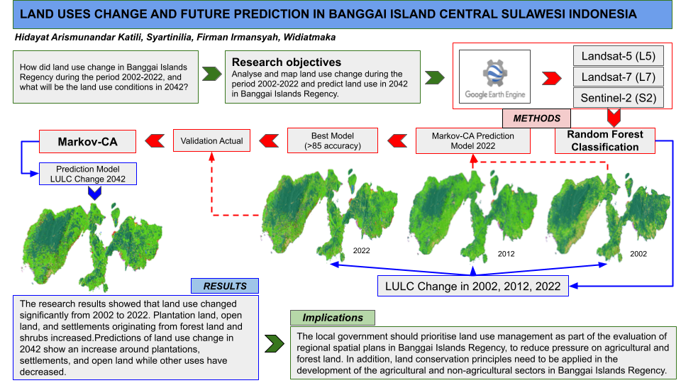
Land use and land cover (LULC) changes can influence policies in a region due to economic and social conditions caused by population growth. The objective of this study is to analyze and map LULC changes in 2002, 2012, and 2022 using the Random Forest approach on Google Earth Engine, and to predict land use in 2042 using Markov-CA, thereby supporting the provision of accurate and sustainable policy data related to LULC in Banggai Islands Regency. This method can provide accurate information about the spatial distribution of rational LULC, balancing development demands with sustainable environmental protection. The study's results indicate that LULC has undergone significant changes from 2002 to 2022. There has been an increase in plantation land, open land, and settlements originating from forest and scrubland. Predictions of LULC changes in 2042 show an increase in plantations, settlements, and open land, while other land uses are declining. Effective land use policies require spatial planning that considers the potential and
limitations of land, as well as the space needs for residential, agricultural, and forest areas. This approach will facilitate the application of land conservation principles in sustainable, balanced agricultural and non-agricultural development in Banggai Islands Regency.
Full text article
References
Ambarwulan, W., Yulianto, F., Widiatmaka, W., Rahadiati, A., Tarigan, S. D., Firmansyah, I., & Hasibuan, M. A. S. (2023). Modelling Land Use/Land Cover Projection Using Different Scenarios in The Cisadane Watershed, Indonesia: Implication on Deforestation and Food Security. The Egyptian Journal of Remote Sensing and Space Science, 26(2), 273-283.
Artikanur, S. D., Widiatmaka, W., Setiawan, Y., & Marimin, M. (2022). Predicting sugar balance as the impact of land-use/land-cover change dynamics in a sugarcane producing regency in East Java, Indonesia. Frontiers in Environmental Science, 10, 787207.
Boreel, A., Silaya, T. M., Parera, L. R., & Latupeirissa, Y. A. (2024). Perubahan Penutupan Lahan Spatio-Temporal Landscape Hutan Dan Dampaknya Terhadap Stock Carbon Sebagai Aksi Mitigasi Menuju Net Sink 2030 Di Negeri Hutumuri. Jurnal Hutan Pulau-Pulau Kecil, 8(1), 61-71.
Breiman, L. (2001). Random Forests. Machine Learning 45. 5–32. Https://Doi.Org/10.1023/A:1010933404324
Briassoulis, H. (2020). Analysis of land use change: theoretical and modeling approaches. 2nd edn. Edited by Scott Loveridge and Randall Jackson. WVU Research Repository
Brockerhoff EG, Barbaro L, Castagneyrol B, Forrester DI, Gardiner B, González-Olabarria JR, Lyver PO, Meurisse N, Oxbrough A, Taki H, Thompson ID van der Plas F & Jactel H. (2017). Forest biodiversity, ecosystem functioning and the provision of ecosystem services. Biodiversity and Conservation, 26, 3005-3035.
Dibaba, W. T., Demissie, T. A., & Miegel, K. (2020). Drivers And Implications of Land Use/Land Cover Dynamics in Finchaa Catchment, Northwestern Ethiopia. Land, 9(4), 113.
Djoharam, V., Widiatmaka, W., Marimin, M., Panuju, D. R., & Tarigan, S. D. (2022). Model Pengelolaan Banjir: Systematic Review dan Arahan untuk Masa Depan. Jurnal Ilmu Lingkungan, 20(3), 524-545.
Eberl, J., Gordeeva, E., & Weber, N. (2021). The Policy Coherence Framework Approach in A Multi-Level Analysis of European, German and Thuringian Climate Policy with A Special Focus On Land Use, Land-Use Change And Forestry (LULUCF). World, 2(3), 415-424.
Fardilla, A., Septiavi, R., Arba, R.M., Sefmaliza, R., Fanbudy, A.R., Afdhal, T., Aadrean, A. and Novarino, W., (2023). Analisis Perubahan Tutupan Lahan Pada Kota Padang Menggunakan Citra Satelit. Jurnal Tanah dan Sumberdaya Lahan, 10(2), 353-367.
Forkuo, E. K., Biney, E., Harris, E., & Quaye-Ballard, J. A. (2021). The Impact of Land Use and Land Cover Changes On Socioeconomic Factors And Livelihood In The Atwima Nwabiagya District Of The Ashanti Region, Ghana. Environmental Challenges, 5, 100226.
Fürst, C., Frank, S., Witt, A., Koschke, L., & Makeschin, F. (2013). Assessment of the effects of forest land use strategies on the provision of ecosystem services at regional scale. Journal of Environmental Management, 127, S96-S116.
Hakim, N., Murtilaksono, K., & Rusdiana, O. (2016). Konflik Penggunaan Lahan Di Taman Nasional Gunung Halimun Salak Kabupaten Lebak. Jurnal Sosiologi Pedesaan, 4(2), 128-138.
Halim, M. A., Rahman, M. M., & Hassan, M. Z. (2013). Agricultural land conversion in the sub-urban area: A case study of Rajshahi Metropolitan city. Journal of Life and Earth Science, 8, 21-30.
Hoirisky, C., Rahmadi, R., & Harahap, T. (2018). Pengaruh Perubahan Pola Penggunaan Lahan Terhadap Banjir Di DAS Buah Kota Palembang. Seminar Nasional Hari Air Sedunia (1).1:14-25.
Indrawati, L., Hartono, H., & Sunarto, S. (2016). Klasifikasi Pohon Keputusan untuk Kajian Perubahan Penggunaan Lahan Kota Semarang Menggunakan Citra Landsat TM/ETM+. Majalah Geografi Indonesia, 23(2), 109-123.
Jin, G., Chen, K., Wang, P., Guo, B., Dong, Y., & Yang, J. (2019). Trade-offs in land-use competition and sustainable land development in the North China Plain. Technological Forecasting and Social Change, 141, 36-46.
Liu, D., Zheng, X., Zhang, C., & Wang, H. (2017). A new temporal–spatial dynamics method of simulating land-use change. Ecological modelling, 350, 1-10.
Lowe, B., & Kulkarni, A. (2015). Multispectral Image Analysis Using Random Forest. International Journal on Soft Computing (IJSC), 6(1).
Mahdianpari, M., Salehi, B., Mohammadimanesh, F., Homayouni, S., & Gill, E. (2018). The First Wetland Inventory Map of Newfoundland at A Spatial Resolution Of 10 M Using Sentinel-1 And Sentinel-2 Data on The Google Earth Engine Cloud Computing Platform. Remote Sensing, 11(1), 43.
McNicol, I. M., Ryan, C. M., & Williams, M. (2015). How resilient are African woodlands to disturbance from shifting cultivation? Ecological Applications, 25(8), 2320-2336.
Meyer, W. B., & Turner, B. L. (1992). Human population growth and global land-use/cover change. Annual review of ecology and systematics, 39-61.
Muke, M. (2019). Reported driving factors of land-use/cover changes and its mounting consequences in Ethiopia: A Review. African Journal of Environmental Science and Technology, 13(7), 273-280.
Mulyani, A., & Agus, F. (2017). Kebutuhan dan ketersediaan lahan cadangan untuk mewujudkan cita-cita Indonesia sebagai lumbung pangan dunia tahun 2045. Analisis Kebijakan Pertanian, 15(1), 1-17.
Mulyaqin, T., Kardiyono, K., Hidayah, I., Ramadhani, F., & Yusron, M. (2022). Deteksi Alih Fungsi Lahan Padi Sawah Menggunakan Sentinel-2 Dan Google Earth Engine di Kota Serang, Provinsi Banten. Jurnal Ilmu Pertanian Indonesia, 27(2), 226-236.
Munthali, M. G., Davis, N., Adeola, A. M., Botai, J. O., Kamwi, J. M., Chisale, H. L., & Orimoogunje, O. O. (2019). Local Perception of Drivers of Land-Use and Land-Cover Change Dynamics Across Dedza District, Central Malawi Region. Sustainability, 11(3), 832.
Nahib, I., Turmudi, T., Windiastuti, R., Suryanta, J., Dewi, R. S., & Lestari, S. (2018). Comparing of land change modeler and Geomod modeling for the assessment of deforestation (case study: forest area at Poso Regency, Central Sulawesi province). International Journal of Advanced Engineering, Management and Science, 4(8), 264314.
Olorunfemi, I. E., Fasinmirin, J. T., Olufayo, A. A., & Komolafe, A. A. (2020). GIS and remote sensing-based analysis of the impacts of land use/land cover change (LULCC) on the environmental sustainability of Ekiti State, southwestern Nigeria. Environment, development and sustainability, 22, 661-692.
Passaris, N., Flower, K. C., Ward, P. R., & Cordingley, N. (2021). Effect of crop rotation diversity and windrow burning of residue on soil chemical composition under long-term no-tillage. Soil and Tillage Research, 213, 105153.
Ren, Y., Lü, Y., Comber, A., Fu, B., Harris, P., & Wu, L. (2019). Spatially Explicit Simulation of Land Use/Land Cover Changes: Current Coverage and Future Prospects. Earth-Science Reviews, 190, 398-415.
Rigo, R., & Houet, T. (2023). Do Land Use And Land Cover Scenarios Support More Integrated Land Use Management?. Land, 12(7), 1414.
Saing, Z., Djainal, H., & Deni, S. (2021). Land use balance determination using satellite imagery and geographic information system: case study in South Sulawesi Province, Indonesia. Geodesy and Geodynamics, 12(2), 133-147.
Sambodo, K. A., Rahayu, M. I., Indriasari, N., & Natsir, M. (2014). Klasifikasi Hutan-Non Hutan Data Alos Palsar Menggunakan Metode Random Forest. Prosiding Seminar Nasional Penginderaan Jauh. 120-127). Lapan.
Sang, L., Zhang, C., Yang, J., Zhu, D., & Yun, W. (2011). Simulation of land use spatial pattern of towns and villages based on CA–Markov model. Mathematical and Computer Modelling, 54(3-4), 938-943.
Sarastika, T., Susena, Y., & Kurniawan, D. (2023). Prediksi konversi lahan pertanian berbasis Artificial Neural Network-Cellular Automata (ANN-CA) di Kawasan Sleman Barat. Jurnal Tanah dan Sumberdaya Lahan, 10(2), 471-482.
Suliman, S., Setiawan, Y. & Syartinilia. (2022). Assessing The Paddy Fields Conversion Using Optical Satellite Imageries: A Case Study in Karawang Regency, West Java. IOP Conference Series: Earth and Environmental Science, 950, (1). 012092.
Suryono, H., Kuswanto, H., & Iriawan, N. (2022). Two-Phase Stratified Random Forest for Paddy Growth Phase Classification: A Case of Imbalanced Data. Sustainability, 14(22), 15252.
Twisa, S., & Buchroithner, M. F. (2019). Land-use and land-cover (LULC) change detection in Wami River Basin, Tanzania. Land, 8(9), 136.
Wang, J., Bretz, M., Dewan, M. A. A., & Delavar, M. A. (2022). Machine Learning in Modelling Land-Use and Land Cover-Change (LULCC): Current Status, Challenges and Prospects. Science of the Total Environment, 822, 153559.
Yudichandra, Fahrizal K. 2019. Perencanaan Penggunaan Lahan untuk Pengembangan dan Konservasi Kebun Apel di Kota Batu, Jawa Timur. Bogor (ID). Institut Pertanian Bogor
Yulianto, F., Maulana, T., & Khomarudin, M. R. (2019). Analysis of the dynamics of land use change and its prediction based on the integration of remotely sensed data and CA-Markov model, in the upstream Citarum Watershed, West Java, Indonesia. International Journal of Digital Earth.
Yulianto, F., Prasasti, I., Pasaribu, J. M., Fitriana, H. L., Zylshal, Haryani, N. S., & Sofan, P. (2016). The dynamics of land use/land cover change modeling and their implication for the flood damage assessment in the Tondano watershed, North Sulawesi, Indonesia. Modeling Earth Systems and Environment, 2, 1-20.
Yusoff, M. M. (2020). Improving The Quality of Life for Sustainable Development. IOP Conf. Series: Earth Environ. Sci. 561 (1), 012020. Https://Doi.Org/10.1088/1755-1315/561/1/012020
Zulfajri, Z., Danoedoro, P., & Murti, S. H. (2021). Klasifikasi Tutupan Lahan Data Landsat-8 OLI Menggunakan Metode Random Forest. Jurnal Penginderaan Jauh Indonesia, 3(1), 1-7.
Authors
Copyright (c) 2025 Hidayat Arismunandar Katili, Syartinilia, Irman Firmansyah, Widiatmaka

This work is licensed under a Creative Commons Attribution 4.0 International License.
Authors who publish with this journal agree to the following terms:
- Authors retain copyright and grant the journal right of first publication with the work simultaneously licensed under a Creative Commons Attribution License that allows others to share the work with an acknowledgement of the work's authorship and initial publication in this journal.
- Authors are able to enter into separate, additional contractual arrangements for the non-exclusive distribution of the journal's published version of the work (e.g., post it to an institutional repository or publish it in a book), with an acknowledgement of its initial publication in this journal.
- Authors are permitted and encouraged to post their work online (e.g., in institutional repositories or on their website) prior to and during the submission process, as it can lead to productive exchanges, as well as earlier and greater citation of published work (See The Effect of Open Access).
Article Details
How to Cite


