
The Impact of National Strategic Project Development (Yogyakarta International Airport) on Land Use Dynamic
Article Sidebar
-
Land Use Change, Land Use Pattern, Sustainable Environment
Abstract
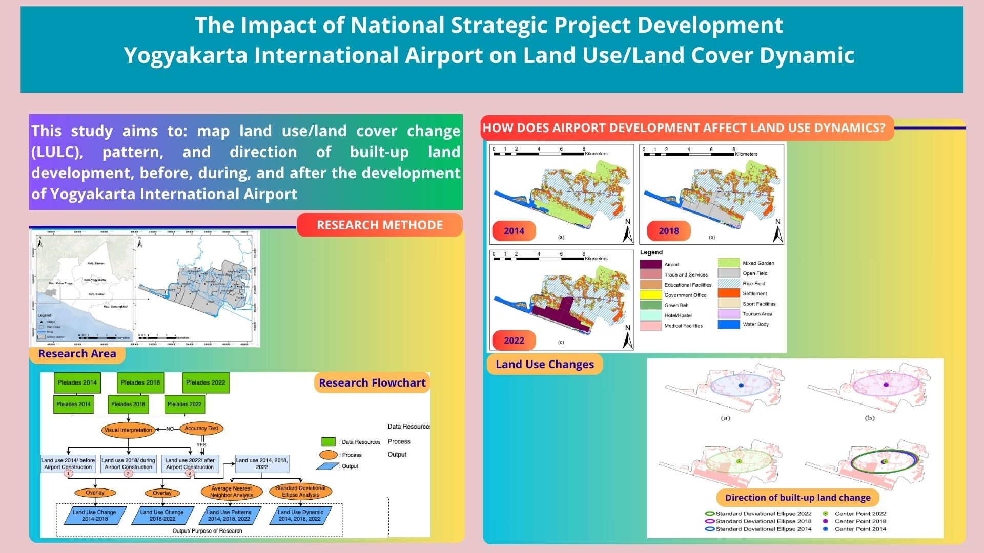
This paper aims to map land use change, pattern, and direction of built-up land development, before, during, and after the development of Yogyakarta International Airport. The data source employed was Pleiades imagery with a spatial resolution of 0.5 m. The visual method was used for image interpretation and the accuracy test was conducted through the confusion matrix. Land use change data obtained by overlay. The distribution pattern is determined by the average nearest neighbour, while the direction of development of built-up land is determined by the standard deviational ellipse The results indicate that the land use map has a very high accuracy of 92.52%. Moreover, the results of the overlay showed that land use changes occurred very massively, in that within eight years there were decreases of mixed plantations decreased by 528.17 Ha and of agricultural land by 112.66 Ha. On the other hand, there was a significant increase in residential area of 29.42 Ha and a service and trade area of 11.2 Ha. The results show the ratio value of the built-up land pattern in 2014 of 0.63, in 2018 of 0.59 and in 2022 of 0.33, with this value the built-up land pattern is clustered. The results showed that there was a change in the direction of the built land pattern which was initially eastward changed to the northeast parallel to the arterial road. Monitoring the pattern of land use dynamics is an important part in planning and regulating spatial patterns and the direction of regional development.
Full text article
References
2. Liang, J.; Chen, C.; Song, Y.; Sun, W.; Yang, G. Long-Term Mapping of Land Use and Cover Changes Using Landsat Images on the Google Earth Engine Cloud Platform in Bay Area - A Case Study of Hangzhou Bay, China. Sustainable Horizons 2023, 7, doi:10.1016/j.horiz.2023.100061.
3. Naboureh, A.; Li, A.; Bian, J.; Lei, G.; Nan, X. Land Cover Dataset of the China Central-Asia West-Asia Economic Corridor from 1993 to 2018. Sci Data 2023, 10, doi:10.1038/s41597-023-02623-z.
4. Siagian, K.; Karuniasa, M.; Mizuno, K. The Estimation of Economic Valuation on Carbon Sequestration of Agroforestry Land System. Jurnal Pengelolaan Sumberdaya Alam dan Lingkungan 2024, 14, 231–240, doi:10.29244/jpsl.14.2.231.
5. Padmini, Y.; Rao, M.S.; Gara, R.R. Temporal Analysis of Land Use and Land Cover Changes in Vizianagaram District, Andhra Pradesh, India Using Remote Sensing and GIS Techniques. Geoplanning: Journal of Geomatics and Planning 2023, 10, 1–10, doi:10.14710/geoplanning.10.1.1-10.
6. Ma, W.; Jiang, G.; Li, W.; Zhou, T. How Do Population Decline, Urban Sprawl and Industrial Transformation Impact Land Use Change in Rural Residential Areas? A Comparative Regional Analysis at the Peri-Urban Interface. J Clean Prod 2018, 205, 76–85, doi:10.1016/j.jclepro.2018.08.323.
7. Atharinafi, Z.; Wijaya, N. Land Use Change and Its Impacts on Surface Runoff in Rural Areas of the Upper Citarum Watershed (Case Study: Cirasea Subwatershed). Journal of Regional and City Planning 2021, 32, 36–55, doi:10.5614/jpwk.2021.32.1.3.
8. Calladine, J.; Border, J.; O’Connell, P.; Wilson, M. Modelling Important Areas for Breeding Waders as a Tool to Target Conservation and Minimise Conflicts with Land Use Change. J Nat Conserv 2022, 126267.
9. Gebrehiwot, A.A.; Hashemi-Beni, L.; Kurkalova, L.A.; Liang, C.L.; Jha, M.K. Using ABM to Study the Potential of Land Use Change for Mitigation of Food Deserts. Sustainability (Switzerland) 2022, 14, doi:10.3390/su14159715.
10. Gur, H. The Future Impact of Climate and Land-Use Changes on Anatolian Ground Squirrels under Different Scenarios _ Elsevier Enhanced Reader.Pdf. Ecol Inform 2022, 70, 1–12.
11. Tuffour, M. Urbanization, Land Scarcity and Urban Farmers’ Mobility: Evidence from Ghana. Journal of Regional and City Planning 2023, 34, 83–100, doi:10.5614/jpwk.2023.34.1.5.
12. Shabani, M.; Darvishi, S.; Rabiei-Dastjerdi, H.; Alavi, S.A.; Choudhury, T.; Solaimani, K. An Integrated Approach For Simulation And Prediction Of Land Use And Land Cover Changes And Urban Growth (Case Study: Sanandaj City In Iran). Journal of the Geographical Institute Jovan Cvijic SASA 2022, 72, 273–289, doi:10.2298/IJGI2203273S.
13. Zhang, L.; Zhang, H.; Xu, E. Information Entropy and Elasticity Analysis of the Land Use Structure Change Influencing Eco-Environmental Quality in Qinghai-Tibet Plateau from 1990 to 2015. Environmental Science and Pollution Research 2022, 29, 18348–18364, doi:10.1007/s11356-021-17978-2.
14. Banai, R. The Aerotropolis: Urban Sustainability Perspectives from the Regional City. J Transp Land Use 2017, 10, 357–373, doi:10.5198/jtlu.2016.889.
15. Utami, W.; Sugiyanto, C.; Rahardjo, N. Mapping of Agricultural Land Conversion in Temon Sub-District after the Development of Yogyakarta International Airport. In Proceedings of the IOP Conference Series: Earth and Environmental Science; Institute of Physics, 2024; Vol. 1290.
16. El Batti, M.M.; Machado, P.G.; Hawkes, A.; de Oliveira Ribeiro, C. Land Use Policies and Their Effects on Brazilian Farming Production. J Nat Conserv 2023, 73, 126373, doi:10.1016/j.jnc.2023.126373.
17. Appold, S.J.; Kasarda, J.D. The Airport City Phenomenon: Evidence from Large US Airports. Urban Studies 2013, 50, 1239–1259, doi:10.1177/0042098012464401.
18. Kasarda, J.D.; Appold, S.J. Planning a Competitive Aerotropolis. In The Economics of International Airline Transport; Advances in Airline Economics; Emerald Group Publishing Limited, 2014; Vol. 4, pp. 281–308 ISBN 978-1-78350-639-2.
19. Gabriele, M.; Brumana, R.; Previtali, M.; Cazzani, A. A Combined GIS and Remote Sensing Approach for Monitoring Climate Change-Related Land Degradation to Support Landscape Preservation and Planning Tools: The Basilicata Case Study. Applied Geomatics 2023, 15, 497–532, doi:10.1007/s12518-022-00437-z.
20. Suwanlee, S.R.; Keawsomsee, S.; Pengjunsang, M.; Homtong, N.; Prakobya, A.; Borgogno-Mondino, E.; Sarvia, F.; Som-ard, J. Monitoring Agricultural Land and Land Cover Change from 2001–2021 of the Chi River Basin, Thailand Using Multi-Temporal Landsat Data Based on Google Earth Engine. Remote Sens (Basel) 2023, 15, doi:10.3390/rs15174339.
21. Slimani, N.; Raham, D. Urban Growth Analysis Using Remote Sensing And Gis Techniques To Support Decision-Making In Algeria—The Case Of The City Of Setif. Journal of the Geographical Institute Jovan Cvijic SASA 2023, 73, 17–32, doi:10.2298/IJGI2301017S.
22. Almeida, A.M.; Delgado, F.; Roque, N.; Ribeiro, M.M.; Fernandez, P. Multitemporal Land Use and Cover Analysis Coupled with Climatic Change Scenarios to Protect the Endangered Taxon Asphodelus Bento-Rainhae Subsp. Bento-Rainhae. Plants 2023, 12, doi:10.3390/plants12162914.
23. Vaggela, A.; Sanapala, H.; Mokka, J.R. Monitoring Land Use and Land Cover Changes Prospects Using Remote Sensing and GIS for Mahanadi River Delta, Orissa, India. Geoplanning 2022, 9, 47–60, doi:10.14710/geoplanning.9.1.47-60.
24. Das, P.C.; Esraz-Ul-Zannat, M. Assessing the Impacts of Land Use-Land Cover Changes on Direct Surface Runoff: A Remote Sensing Approach in Khulna City. Water Science and Technology 2022, 85, 3122–3144, doi:10.2166/wst.2022.097.
25. Utami, N.T.; Pigawati, B. The Correlation Between Urban Development and Land Surface Temperature Change in Palembang City. Geoplanning 2022, 9, 89–102, doi:10.14710/geoplanning.9.2.89-102.
26. Sholikah, L.N.; Nisa, Z.K.; Pratama, B.F.; Pradipta, A.G.; Ngadisih; Susanto, S.; Prihanantya, A.S.; Tirtalistyani, R.; Arif, S.S. Identification of Agricultural Land Use Change Based on Machine Learning for Regional Food Security Analysis in the Mountainous Region of Kulon Progo Regency.; IOP Publishing Ltd: Department of Agricultural and Biosystems Engineering, Faculty of Agricultural Technology, Universitas Gadjah Mada, Jl. Flora Bulaksumur 1, Yogyakarta, Indonesia, 2021; Vol. 922.
27. Tikuye, B.G.; Rusnak, M.; Manjunatha, B.R.; Jose, J. Land Use and Land Cover Change Detection Using the Random Forest Approach: The Case of The Upper Blue Nile River Basin, Ethiopia. Global Challenges 2023, doi:10.1002/gch2.202300155.
28. Indrayati, A.; Rijanta, R.; Muta’ali, L.; Rachmawati, R. Built-Up Area Changes, Spatial Pattern and Urban Sprawling in Kedungsepur Metropolitan Area. International Journal of Sustainable Development and Planning 2023, 18, 2541–2546, doi:10.18280/ijsdp.180825.
29. Zhang, X.; Guo, X.; Zhang, X. Assessing the Policy Synergy among Power, Carbon Emissions Trading and Tradable Green Certificate Market Mechanisms on Strategic Gencos in China. Energy 2023, 278, 127833, doi:10.1016/j.energy.2023.127833.
30. Kamruzzaman, M.; Aston, L.; Baker, D.; Braun, B.; Shatu, F. Changes in Land Use Typology of Global Airports: An Empirical Investigation with Implications for the Aerotropolis Concept. J Transp Geogr 2021, 97, doi:10.1016/j.jtrangeo.2021.103217.
31. Surya, B.; Salim, A.; Hernita, H.; Suriani, S.; Menne, F.; Rasyidi, E.S. Land Use Change, Urban Agglomeration, and Urban Sprawl: A Sustainable Development Perspective of Makassar City, Indonesia. Land (Basel) 2021, 10, doi:10.3390/land10060556.
32. Lelong, C.; Herimandimby, H. Land Use / Land Cover Map of Vavatenina Region (Madagascar) Produced by Object-Based Analysis of Very High Spatial Resolution Satellite Images and Geospatial Reference Data. Data Brief 2022, 44, doi:10.1016/j.dib.2022.108517.
33. Melis, M.T.; Pisani, L.; De Waele, J. On the Use of Tri-Stereo Pleiades Images for the Morphometric Measurement of Dolines in the Basaltic Plateau of Azrou (Middle Atlas, Morocco). Remote Sens (Basel) 2021, 13, doi:10.3390/rs13204087.
34. Rahman, A.; Utami, W.; Sutaryono Pendekatan Interpretasi Visual Dan Digital Citra Pleiades Untuk Klasifikasi Penutup Lahan. Geography, Jurnal Kajian, Penelitian dan Pengembangan Pendidikan 2022, 10, 18–31.
35. James, D.; Collin, A.; Mury, A.; Costa, S. Very High Resolution Land Use and Land Cover Mapping Using Pleiades-1 Stereo Imagery and Machine Learning. In Proceedings of the International Archives of the Photogrammetry, Remote Sensing and Spatial Information Sciences - ISPRS Archives; International Society for Photogrammetry and Remote Sensing, August 6 2020; Vol. 43, pp. 675–682.
36. Salouw, E.; Widodo Dwi Pramono, R. Typology of Tourism Village Settlement in Indonesia. Sodality: Jurnal Sosiologi Pedesaan 2023, 10, 295–304, doi:10.22500/10202241282.
37. Song, K.H.; Suh, W. Perceptions on Regional Benefit of Airport Development and Operation. Applied Sciences (Switzerland) 2022, 12, doi:10.3390/app12094340.
38. Xiong, C.; Tian, Y.; Liu, X.; Tan, R.; Luan, Q. The Different Impacts of Airports on the Ecological Environment under Distinct Institutional Contexts. Land (Basel) 2022, 11, doi:10.3390/land11020291.
39. Rijanta, R.; Baiquni, M.; Rachmawati, R.; Musthofa, A. Relocations of the Households Affected by the Development of the New Yogyakarta International Airport, Indonesia: Problems and Livelihood Prospects. Human Geogr 2022, 16, 191–209, doi:10.5719/hgeo.2022.162.5.
40. McNair, A.W.; Kwon, K. Cargo Airport Planning: Discerning Spatial Distributions of Freight Development in Airport-Adjacent Communities. Transp Res Rec 2023, doi:10.1177/03611981231178808.
Authors
Copyright (c) 2025 Westi Utami, Catur Sugiyanto, Noorhadi Rahardjo

This work is licensed under a Creative Commons Attribution 4.0 International License.
Authors who publish with this journal agree to the following terms:
- Authors retain copyright and grant the journal right of first publication with the work simultaneously licensed under a Creative Commons Attribution License that allows others to share the work with an acknowledgement of the work's authorship and initial publication in this journal.
- Authors are able to enter into separate, additional contractual arrangements for the non-exclusive distribution of the journal's published version of the work (e.g., post it to an institutional repository or publish it in a book), with an acknowledgement of its initial publication in this journal.
- Authors are permitted and encouraged to post their work online (e.g., in institutional repositories or on their website) prior to and during the submission process, as it can lead to productive exchanges, as well as earlier and greater citation of published work (See The Effect of Open Access).
Article Details
How to Cite


