
Estimation of Stand Volume Using Empirical Modeling Based on Multi-sensor Imagery with Random Forest Regression

Article Sidebar
-
natural production forest, FCD model transformation, Sentinel-1, Sentinel-2
Abstract
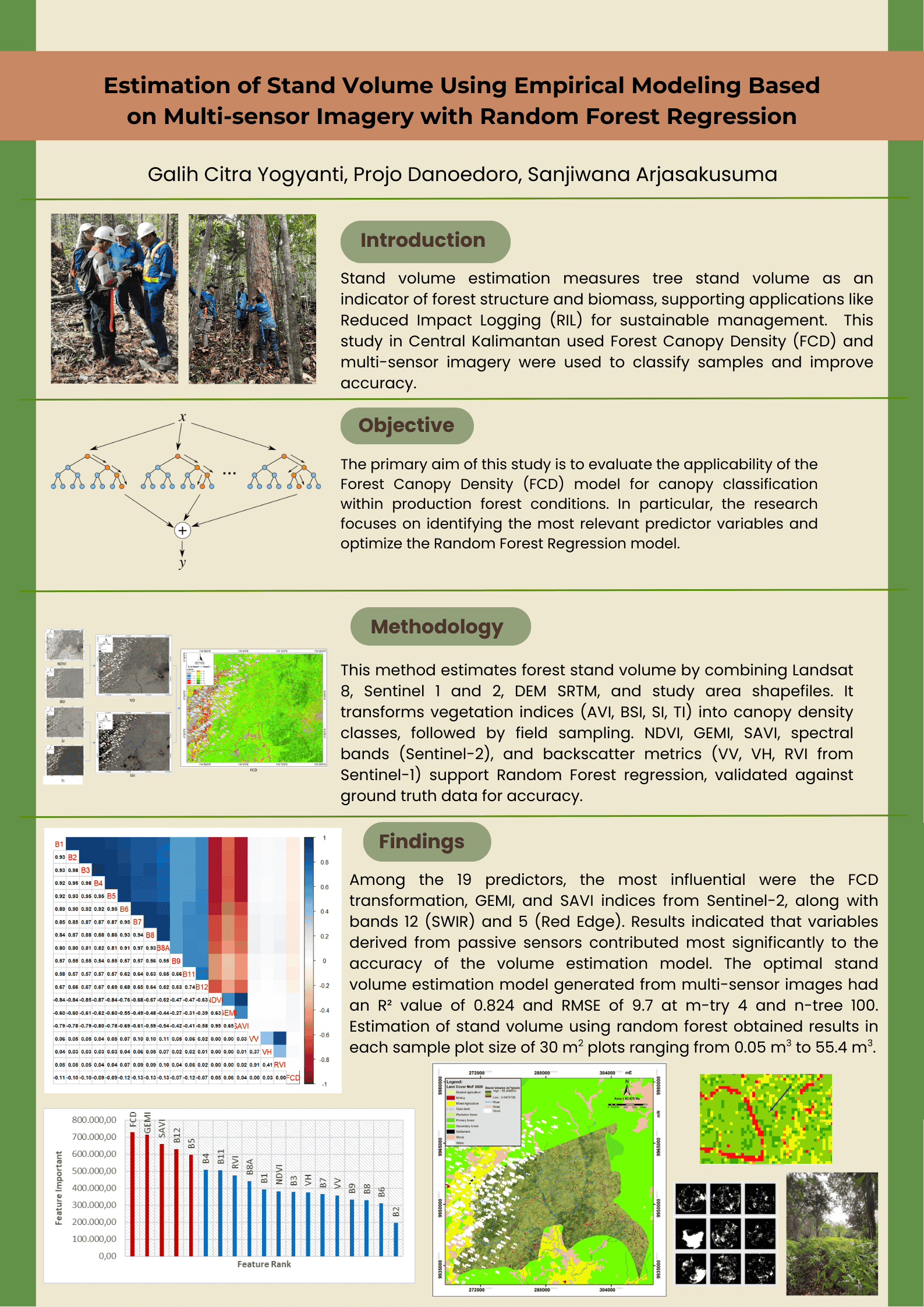
Stand volume estimation is the process of measuring the volume of tree stands, which serves as an indicator of forest ecosystem structure and biomass. This assessment supports various applications, including the implementation of reduced impact logging, a sustainable forest management strategy that employs selective harvesting based on tree maturity to preserve ecological integrity. However, measuring resources in large, complex forests with limited access is challenging for detailed resource measurement. This study was conducted in Central Kalimantan Province, as one of the production forest land uses with a naturally growing silviculture system. Forest canopy density (FCD) is employed to determine the classification of field samples. Furthermore, multi-sensor imagery was employed to derive input variables for stand volume estimation. Among the 19 predictors, the most influential were the FCD transformation, GEMI, and SAVI indices from Sentinel-2, along with bands 12 (SWIR) and 5 (red edge). Results indicated that variables derived from passive sensors contributed most significantly to the accuracy of the volume estimation model. The optimal stand volume estimation model generated from multi-sensor images had an R² value of 0.824 and RMSE of 9.7 at m-try 4 and n-tree 100. Estimation of stand volume using random forest obtained results in each sample plot size of 30 m² plots ranging from 0.05 m³ to 55.4 m³.
Full text article
References
Abdollahnejad, A., Panagiotidis, D., & Surový, P. (2017). Forest canopy density assessment using different approaches-Review. Journal of Forest Science, 63(3), 107–116. https://doi.org/10.17221/110/2016-JFS
Arjasakusuma, S., Kusuma, S. S., & Phinn, S. (2020). Evaluating variable selection and machine learning algorithms for estimating forest heights by combining lidar and hyperspectral data. ISPRS International Journal of Geo-Information, 9(9), Article 507. https://doi.org/10.3390/ijgi9090507
Ataee, M. S., Maghsoudi, Y., Latifi, H., & Fadaie, F. (2019). Improving estimation accuracy of growing stock by multi-frequency SAR and multi-spectral data over Iran’s heterogeneously-structured broadleaf Hyrcanian forests. Forests, 10(8), Article 641. https://doi.org/10.3390/f10080641
Bannari, A., Morin, D., Bonn, F., & Huete, A. R. (1995). A review of vegetation indices. Remote Sensing Reviews, 13(1–2), 95–120. https://doi.org/10.1080/02757259509532298
Berninger, A., Lohberger, S., Stängel, M., & Siegert, F. (2018). SAR-based estimation of above-ground biomass and its changes in tropical forests of Kalimantan using L- and C-band. Remote Sensing, 10(6), Article 831. https://doi.org/10.3390/rs10060831
Brede, B., Bartholomeus, H. M., Barbier, N., Pimont, F., Vincent, G., & Herold, M. (2022). Peering through the thicket: Effects of UAV LiDAR scanner settings and flight planning on canopy volume discovery. International Journal of Applied Earth Observation and Geoinformation, 114, Article 103056. https://doi.org/10.1016/j.jag.2022.103056
Breiman, L. (2001). Random forests. Machine Learning, 45, 5–32. https://doi.org/10.1023/A:1010933404324
Budiharto, W. (2016). Machine learning and computational intelligence. Yogyakarta: Andi.
Burkov, A. (2019). The hundred-page machine learning book. Andriy Burkov Publ.
Congalton, R. G., & Green, K. (2019). Assessing the accuracy of remotely sensed data: Principles and practices (3rd ed.). CRC Press. https://doi.org/10.1201/9780429052729
Danoedoro, P. (2012). Pengantar penginderaan jauh digital. Yogyakarta: Andi.
Díaz, G. M. (2023). Optimizing forest canopy structure retrieval from smartphone-based hemispherical photography. Methods in Ecology and Evolution, 14(3), 875–884. https://doi.org/10.1111/2041-210X.14059
Esteban, J., McRoberts, R. E., Fernández-Landa, A., Tomé, J. L., & Næsset, E. (2019). Estimating forest volume and biomass and their changes using random forests and remotely sensed data. Remote Sensing, 11(16), 1944. https://doi.org/10.3390/rs11161944
Forrester, D. I., Ammer, C., Annighöfer, P. J., Barbeito, I., Bielak, K., Bravo-Oviedo, A., Coll, L., del Río, M., Drössler, L., Heym, M., Hurt, V., Löf, M., den Ouden, J., Pach, M., Pereira, M. G., Plaga, B. N. E., Ponette, Q., Skrzyszewski, J., Sterba, H., …, & Pretzsch, H. (2018). Effects of crown architecture and stand structure on light absorption in mixed and monospecific Fagus sylvatica and Pinus sylvestris forests along a productivity and climate gradient through Europe. Journal of Ecology, 106(2), 746–760. https://doi.org/10.1111/1365-2745.12803
Frazer, G. W., Canham, C. D., & Lertzman, K. P. (1999). Gap light analyzer (GLA). Imaging software to extract canopy structure and gap light transmission indices from true-colour fisheye photographs. User manual and program documentation, version 2.0. Simon Fraser University, Burnaby, British Columbia-the Institute of Ecosystem Studies, Millbrook, New York.
Frison, P. L., Fruneau, B., Kmiha, S., Soudani, K., Dufrêne, E., Le Toan, T., Koleck, T., Villard, L., Mougin, E., & Rudant, J. P. (2018). Potential of Sentinel-1 data for monitoring temperate mixed forest phenology. Remote Sensing, 10(12), Article 2049. https://doi.org/10.3390/rs10122049
Ghorbanian, A., Zaghian, S., Asiyabi, R. M., Amani, M., Mohammadzadeh, A., & Jamali, S. (2021). Mangrove ecosystem mapping using Sentinel-1 and Sentinel-2 satellite images and random forest algorithm in google earth engine. Remote Sensing, 13(13), 1–18. https://doi.org/10.3390/rs13132565
Giertych, M. J., Karolewski, P., & Oleksyn, J. (2015). Carbon allocation in seedlings of deciduous tree species depends on their shade tolerance. Acta Physiologiae Plantarum, 37(216), 1–15. https://doi.org/10.1007/s11738-015-1965-x
Giri Ananto, W. H., Hadi, H. A., Sandhini Putri, A. F., Hanum, D. N., Puji Wiryawan, B. K., Prabaswara, R. R., & Arjasakusuma, S. (2019). Assessment of dual polarization in Sentinel-1 data for estimating forest aboveground biomass: Case study of Barru Regency, South Sulawesi. Proceedings Sixth International Symposium on LAPAN-IPB Satellite, 11372, Article 1137214. https://doi.org/10.1117/12.2540845
González-Alonso, F., Merino-De-Miguel, S., Roldán-Zamarrón, A., García-Gigorro, S., & Cuevas, J. M. (2006). Forest biomass estimation through NDVI composites. The role of remotely sensed data to assess Spanish forests as carbon sinks. International Journal of Remote Sensing, 27(24), 5409–5415. https://doi.org/10.1080/01431160600830748
Heriansyah, I., Hamid, H. A., Nurudin, A. A., Ibrahim, S., Abdu, A., & Alias, M. A. (2022). Assessment of reduced impact logging technique at different logging intensity. IOP Conference Series: Earth and Environmental Science, 959, Article 012067. https://doi.org/10.1088/1755-1315/959/1/012067
Himayah, S., Hartono, & Danoedoro, P. (2016). The utilization of Landsat 8 multitemporal imagery and forest canopy density (FCD) model for forest reclamation rriority of natural disaster areas at Kelud Mountain, East Java. IOP Conference Series: Earth and Environmental Science, 47, Article 012043. https://doi.org/10.1088/1755-1315/47/1/012043
Huete, A. R. (1988). A soil-adjusted vegetation index (SAVI). Remote Sensing of Environment, 25(3), 295–309. https://doi.org/10.1016/0034-4257(88)90106-X
Iizuka, K., Hayakawa, Y. S., Ogura, T., Nakata, Y., Kosugi, Y., & Yonehara, T. (2020). Integration of multi-sensor data to estimate plot-level stem volume using machine learning algorithms-case study of evergreen conifer planted forests in Japan. Remote Sensing, 12(10), Article 1649. https://doi.org/10.3390/rs12101649
Ismail, M., Hartono, & Danoedoro, P. (2017). The application of forest cover density (FCD) model for structural composition of vegetation changes in part of Lore Lindu National Park, Central Sulawesi Province. IOP Conference Series: Earth and Environmental Science, 98, Article 012056. https://doi.org/10.1088/1755-1315/98/1/012056
Jensen, J. R. (2009). Remote Sensing of the environment, an earth resource perspective (2nd ed.). Pearson Education.
Kalkhan, M. A. (2011). Spatial statistics. GeoSpatial information modelling and thematic mapping. CRC Press, Taylor & Francis Group. https://doi.org/10.1201/9781439891117
Kuchler, A.W. & Zonnevald, I. S. (Eds.). (1988). Vegetation mapping (Handbook of vegetation science, 10). Kluwer Academic Publishers.
Kumar, S. D., Rao, S. S., & Sharma, J. R. (2013). Radar vegetation ias an alternative to NDVI for monitoring of soyabean and cotton. Indian Cartographer, 33, 91–96.
Manan, F. A., Saleh, M. B., Jaya, I. N. S., & Mukarom, U. S. (2019). Algorithm for assessing forest stand productivity index using leaf area index. Indonesian Journal of Electrical Engineering and Computer Science, 16(3), 1311–1319. https://doi.org/10.11591/ijeecs.v16.i3.pp1311-1319
Mas Sukarna, R., & Syahid, Y. (2015). FCD application of Landsat for monitoring mangrove in Central Kalimantan. Indonesian Journal of Geography, 47(2), 160–170. https://doi.org/10.22146/ijg.9259
McCoy, R. M. (2005). Field methods in remote sensing. Kluwer Academic Publishers. https://doi.org/http://doi.wiley.com/10.1111/j.1541- 0064.2006.00161_2.x
Medasani, S, & Reddy, G. U. (2018). Analysis and evaluation of speckle filters by using polarimetric synthetic aperture radar data through local statistics. In 2018 second international conference on electronics, communication and aerospace technology (pp. 169–174). Coimbatore, India. https://doi.org/10.1109/ICECA.2018.8474567
Mullissa, A., Vollrath, A., Odongo-Braun, C., Slagter, B., Balling, J., Gou, Y., Gorelick, N., & Reiche, J. (2021). Sentinel-1 SAR backscatter analysis ready data preparation in Google Earth Engine. Remote Sensing, 13(10) Article 1954. https://doi.org/10.3390/rs13101954
Nasiri, V., Sadeghi, S. M. M., Moradi, F., Afshari, S., Deljouei, A., Griess, V. C., Maftei, C., & Borz, S. A. (2022). The influence of data density and integration on forest canopy cover mapping using Sentinel-1 and Sentinel-2 time series in Mediterranean Oak Forests. ISPRS International Journal of Geo-Information, 11(8), Article 423. https://doi.org/10.3390/ijgi11080423
Nasirzadehdizaji, R., Sanli, F. B., Abdikan, S., Cakir, Z., Sekertekin, A., & Ustuner, M. (2019). Sensitivity analysis of multi-temporal Sentinel-1 SAR parameters to crop height and canopy coverage. Applied Sciences, 9(4), Article 655. https://doi.org/10.3390/app9040655
Kementerian Lingkungan Hidup dan Kehutanan. (2021). Peraturan Menteri Nomor 8 Tahun 2021 tentang Tata Hutan dan Penyusunan Rencana Pengelolaan Hutan, serta Pemanfaatan Hutan di Hutan Lindung dan Hutan Produksi. Peraturan.go.id. https://peraturan.go.id/id/permen-lhk-no-8-tahun-2021
Pinty, B., & Verstraete, M. M. (1992). GEMI: A non-linear index to monitor global vegetation from satellites. Vegetatio, 101(1), 15–20. https://doi.org/10.1007/BF00031911
Rao, K. V. R. (2023). Removal of speckle noise from SAR images using various filters. International Journal Of Engineering Research & Technology, 12(5), 135–141. https://doi.org/10.17577/IJERTV12IS050043
Rikimaru, A., Roy, P. S., & Miyatake, S. (2002). Tropical forest cover density mapping. International Society Tropical Ecology, 43(1), 39–47.
Rondeaux, G., Steven, M., & Baret, F. (1996). Optimization of soil-adjusted vegetation indices. Remote Sensing of Environment, 55(2), 95–107. https://doi.org/10.1016/0034-4257(95)00186-7
Roy, P. S., Miyatake, S., & Rikimaru, A. (1997). Biophysical spectral response modeling approach for forest density stratification. Geospatial World. 1984, 1–5.
Salsabila, H. N., & Danoedoro, P. (2021, November 22–24). Comparing two diffferent radiometric corrections in a vegetation mapping of mountainous area using forest canopy density transformation [Conference presentation]. The 42nd Asian Conference on Remote Sensing ACRS 2021, Can Tho city, Vietnam.
Schratz, P., Muenchow, J., Iturritxa, E., Richter, J., & Brenning, A. (2019). Hyperparameter tuning and performance assessment of statistical and machine-learning algorithms using spatial data. Ecological Modelling, 406, 109–120. https://doi.org/10.1016/j.ecolmodel.2019.06.002
Shehzad, K., Anwar, A., Samia, A., Areeba, B. I., & Naveed, A. (2022). Mapping and monitoring forest landscape restoration using Landsat-8 images. Bulletin of the Transilvania University of Brasov, Series II: Forestry, Wood Industry, Agricultural Food Engineering, 15–64(2), 43–64. https://doi.org/10.31926/but.fwiafe.2022.15.64.2.4
Sprintsin, M., Karnieli, A., Sprintsin, S., Cohen, S., & Berliner, P. (2009). Relationships between stand density and canopy structure in a dryland forest as estimated by ground-based measurements and multi-spectral spaceborne images. Journal of Arid Environments, 73(10), 955–962. https://doi.org/10.1016/j.jaridenv.2009.04.011
Sukarna, R. M. (2008). Aplikasi forest canopy density citra Landsat 7 ETM untuk menentukan luas tajuk (crown areal index) dan kerapatan tegakan (stand density) hutan rawa gambut di DAS Sebangau Provinsi Kalimantan Tengah. Majalah Geografi Indonesia, 22(1), 1–21.
Szigarski, C., Jagdhuber, T., Baur, M., Thiel, C., Parrens, M., Wigneron, J. P., Piles, M., & Entekhabi, D. (2018). Analysis of the radar vegetation index and potential improvements. Remote Sensing, 10(11), Article 1776. https://doi.org/10.3390/rs10111776
Umarhadi, D. A., & Danoedoro, P. (2020). The effect of topographic correction on canopy density mapping using satellite imagery in mountainous area. International Journal on Advanced Science, Engineering and Information Technology, 10(3), 1317–1325. https://doi.org/10.18517/ijaseit.10.3.7739
Villarroya-Carpio, A., Lopez-Sanchez, J. M., & Engdahl, M. E. (2022). Sentinel-1 interferometric coherence as a vegetation index for agriculture. Remote Sensing of Environment, 280, Article 113208. https://doi.org/10.1016/j.rse.2022.113208
Vollrath, A., Mullissa, A., & Reiche, J. (2020). Angular-based radiometric slope correction for Sentinel-1 on google earth engine. Remote Sensing, 12(11), Article 1867. https://doi.org/10.3390/rs12111867
Wijaya, A., Liesenberg, V., & Gloaguen, R. (2010). Retrieval of forest attributes in complex successional forests of Central Indonesia: Modeling and estimation of bitemporal data. Forest Ecology and Management, 259(12), 2315–2326. https://doi.org/10.1016/j.foreco.2010.03.004
Wittke, S., Yu, X., Karjalainen, M., Hyyppä, J., & Puttonen, E. (2019). Comparison of two-dimensional multitemporal Sentinel-2 data with three-dimensional remote sensing data sources for forest inventory parameter estimation over a boreal forest. International Journal of Applied Earth Observation and Geoinformation, 76, 167–178. https://doi.org/10.1016/j.jag.2018.11.009
Yadav, V. P., Prasad, R., Bala, R., Srivastava, P. K., & Vanama, V. S. K. (2022). Appraisal of dual polarimetric radar vegetation index in first order microwave scattering algorithm using Sentinel-1A (C-band) and ALOS-2 (L-band) SAR data. Geocarto International, 37(21), 6232–6250. https://doi.org/10.1080/10106049.2021.1933209
Yang, S., Feng, Q., Yang, W., & Gao, X. (2023). Simple, low-cost estimation of potato above-ground biomass using improved canopy leaf detection method. American Journal of Potato Research, 100, 143–162. https://doi.org/10.1007/s12230-022-09897-w
Yu, Z., Wang, W., Li, C., Liu, W., & Yang, J. (2018). Speckle noise suppression in SAR images using a three-step algorithm. Sensors, 18(11). Article 3643. https://doi.org/10.3390/s18113643
Zhu, X., & Liu, D. (2015). Improving forest aboveground biomass estimation using seasonal Landsat NDVI time-series. ISPRS Journal of Photogrammetry and Remote Sensing, 102, 222–231. https://doi.org/10.1016/j.isprsjprs.2014.08.014
Authors
Copyright (c) 2026 Jurnal Manajemen Hutan Tropika

This work is licensed under a Creative Commons Attribution 4.0 International License.
Jurnal Manajemen Hutan Tropika is an open access journal which means that all contents is freely available without charge to the user or his/her institution. Users are allowed to read, download, copy, distribute, print, search, or link to the full texts of the articles in this journal without asking prior permission from the publisher or the author. This is in accordance with the Budapest Open Access Initiative (BOAI) definition of open access.Article Details
How to Cite