
Integrating Multi-Variable Driving Factors to Improve Land Use & Land Cover Classification Accuracy using Machine Learning Approaches: A Case Study from Lombok Island

Article Sidebar
-
land cover classification, machine learning, Random Forest, Lombok Island
Abstract
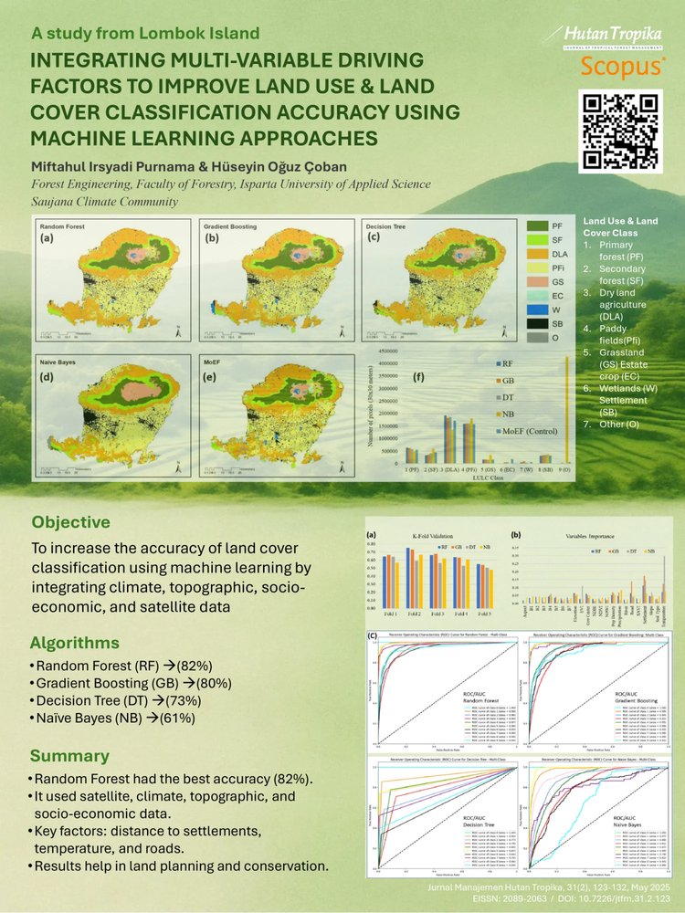
Accurate classification of land cover is essential for effective land management and environmental monitoring. This study aimed to enhance land cover classification for Lombok Island using advanced machine learning algorithms. The models employed include Random Forest, Gradient Boosting, Decision Tree, and Naive Bayes, integrating a wide range of variables, such as Landsat satellite imagery, spectral indices, physiographic, climatic, and socio-economic data. Among these, Random Forest demonstrated the highest model accuracy at 82%, followed by Gradient Boosting at 80%, Decision Tree at 73%, and Naïve Bayes at 61%. In field validation assessments, comparing the predictions of these machine learning models with ground truth data, Random Forest was the most reliable, achieving an overall accuracy of 88%. This superior performance is largely due to the multi-variable approach, which allows the model to mitigate issues like cloud cover in satellite images. The key variables that significantly influenced the land cover classification on Lombok Island include proximity to settlements, temperature, and distance to roads. These results provide essential insights for land management strategies, enabling policymakers and stakeholders to make informed decisions on sustainable development, urban planning, and environmental conservation in rapidly changing landscapes.
Full text article
References
Alzubade, M., Ozcan, O., Musaoglu, N., & Türkeş, M. (2021). Observed impacts of climate variability on LULC in the Mesopotamia Region. Computers, Materials & Continua, 67(2), 2255–2269. https://doi.org/10.32604/CMC.2021.013565
Ao, Y., Li, H., Zhu, L., Ali, S., & Yang, Z. (2019). The linear random forest algorithm and its advantages in machine learning assisted logging regression modeling. Journal of Petroleum Science and Engineering, 174, 776–789. https://doi.org/10.1016/J.PETROL.2018.11.067
Bin, J., Ai, F. F., Fan, W., Zhou, J. H., Yun, Y. H., & Liang, Y. Z. (2016). A modified random forest approach to improve multi-class classification performance of tobacco leaf grades coupled with NIR spectroscopy. RSC Advances, 6(36), 30353–30361. https://doi.org/10.1039/C5RA25052H
Badan Standardisasi Nasional. (2020). Klasifikasi penutup lahan - Bagian 1: Skala kecil dan menengah. https://big.go.id/assets/download/sni/SNI/15.%20SNI%207645-2010%20Klasifikasi%20penutup%20lahan.pdf#:~:text=Standar%20Nasional%20Indonesia%20%28SNI%29%207645%3A2010%2C%20Klasifikasi%20penutup%20lahan,lahan%20skala%201%3A1.000.000%2C%201%3A250.000%2C%20dan%201%3A50.000%20atau%201%3A25.000
Chicco, D., & Jurman, G. (2023). The Matthews correlation coefficient (MCC) should replace the ROC AUC as the standard metric for assessing binary classification. BioData Mining, 16(1), Article 4. https://doi.org/10.1186/S13040-023-00322-4
Çoban, H. O., & Erdin, C. (2020). Forest fire risk assessment using gis and ahp integration in bucak forest enterprise, Turkey. Applied Ecology and Environmental Research, 18(1), 1567–1583. https://doi.org/10.15666/aeer/1801_15671583
da Silva, V. S., Salami, G., da Silva, M. I. O., Silva, E. A., Monteiro Junior, J. J., & Alba, E. (2020). Methodological evaluation of vegetation indexes in land use and land cover (LULC) classification. Geology, Ecology, and Landscapes, 4(2), 159–169. https://doi.org/10.1080/24749508.2019.1608409
Darapureddy, N., Karatapu, N., & Battula, T. K. (2019). Research of machine learning algorithms using k-fold cross validation. International Journal of Engineering and Advanced Technology, 8(6 Special issue), 215–218. https://doi.org/10.35940/IJEAT.F1043.0886S19
Desjardins, É., Lai, S., Houle, L., Caron, A., Thériault, V., Tam, A., Vézina, F., & Berteaux, D. (2023). Algorithms and predictors for land cover classification of polar deserts: A case study highlighting challenges and recommendations for future applications. Remote Sensing, 15(12), Article 3090. https://doi.org/10.3390/RS15123090/S1
Dewi, B. V. T., & Sukmawati, A. M. (2020). Pemetaan perubahan kondisi sosial ekonomi masyarakat pasca gempa bumi di Kecamatan Tanjung, Kabupaten Lombok Utara. Jurnal Tata Kota Dan Daerah, 12(2), 83–93. https://doi.org/10.21776/ub.takoda.2020.012.02.3
Direktorat Jenderal Planologi Kehutanan. (2015). PERDIRJEN Planologi Kehutanan No P.1-VII-IPSDH-2015 tentang Pedoman Pemantauan Penutupan Lahan. Jakarta: Direktorat Jenderal Planologi Kehutanan.
Gaur, S., & Singh, R. (2023). A comprehensive review on land use/land cover (LULC) change modeling for urban development: Current status and future prospects. Sustainability, 15(2), Article 903. https://doi.org/10.3390/SU15020903
Gavade, A. B., & Rajpurohit, V. S. (2021). Systematic analysis of satellite image-based land cover classification techniques: Literature review and challenges. International Journal of Computers and Applications, 43(6), 514–523. https://doi.org/10.1080/1206212X.2019.1573946
Herwirawan, F. X., Kusmana, C., Suhendang, E., & Widiatmaka, W. (2017). Changes in land use/land cover patterns in Indonesia’s border and their relation to population and poverty. Jurnal Manajemen Hutan Tropika, 23(2), 90–101. https://doi.org/10.7226/jtfm.23.2.90
Ibrahim, B., & Ash’aari, Z. H. (2023). Climate variability in relation to land use and land cover (LULC) changes in Kota Bharu, Kelantan, Malaysia. Planning Malaysia, 21(5), 1–16. https://doi.org/10.21837/PM.V21I29.1352
Jaya, I. N. S. , Kleinn, C. , Melati, D. , Fehrmann, L. , Pérez-Cruzado, C. , Septyawardani, E. , Dhani, F. A. R., & Wachjuni, S. (2015). Utilizing multi-source data for sustainable forest managements in Indonesia. In Bridging the gap between information needs and forest inventory capacity. Proceedings of the 5th international DAAD workshop (pp. 163–181). Durban dan Pietermaritzburg, South Africa.
Kadiyala, A., & Kumar, A. (2017). Applications of Python to evaluate environmental data science problems. Environmental Progress & Sustainable Energy, 36(6), 1580–1586. https://doi.org/10.1002/EP.12786
Khaldi, L., Elabed, A., & El Khanchoufi, A. (2024). Performance evaluation of machine learning algorithms for LULC classification: A case study of Fez-Meknes region. E3S Web of Conferences, 527, Article 02012. https://doi.org/10.1051/E3SCONF/202452702012
Khan, K., Sadono, R., Wilopo, W., & Hermawan, M. T. T. (2024). Development of land cover and carbon storage in Plawangan Hill of Gunung Merapi National Park, Yogyakarta, using Landsat data series 2009, 2013, 2017, and 2023. Jurnal Manajemen Hutan Tropika, 30(1), 107–107. https://doi.org/10.7226/JTFM.30.1.107
Kim, C. (2016). Land use classification and land use change analysis using satellite images in Lombok Island, Indonesia. Forest Science and Technology, 12(4), 183–191. https://doi.org/10.1080/21580103.2016.1147498
Le, T. D. H., Pham, L. H., Dinh, Q. T., Hang, N. T. T., & Tran, T. A. T. (2022). Rapid method for yearly LULC classification using random forest and incorporating time-series NDVI and topography: A case study of Thanh Hoa Province, Vietnam. Geocarto International, 37(27), 17200–17215. https://doi.org/10.1080/10106049.2022.2123959
Li, Y., Yang, L., Qiu, X., & Bi, C. (2024). Interactive cloud detection based on dynamic mode decomposition. In Proceedings of the 2024 international conference on information technology, data science, and optimization (I-DO '24). Association for Computing Machinery (pp. 91–98). New York. https://doi.org/10.1145/3658549.3658571
Mitra, S., & Basu, S. (2023). Remote sensing based land cover classification using machine learning and deep learning: A comprehensive survey. International Journal of Next-Generation Computing, 14(2), 381–399. https://doi.org/10.47164/IJNGC.V14I2.1137
Patil, A., & Panhalkar, S. (2023). A comparative analysis of machine learning algorithms for land use and land cover classification using google earth engine platform. Journal of Geomatics, 17(2), 226–233. https://doi.org/10.58825/JOG.2023.17.2.96
Prasad, A. D., Ganasala, P., Hernández-Guzmán, R., & Fathian, F. (2022). Remote sensing satellite data and spectral indices: An initial evaluation for the sustainable development of an urban area. Sustainable Water Resources Management, 8(1), Article 19. https://doi.org/10.1007/S40899-022-00607-2
Purnama, M. I., & Çoban, H. O. (2024). Dynamic trajectories of land use and land cover changes in Lombok Island, West Nusa Tenggara, Indonesia. Turkish Journal of Forestry, 25(4), 447–458. https://doi.org/10.18182/TJF.1524144
Purnama, M. I., Jaya, I. N. S., Syaufina, L., Çoban, H. O., & Raihan, M. (2024). Predicting forest fire vulnerability using machine learning approaches in the Mediterranean Region: A case study of Türkiye. IOP Conference Series: Earth and Environmental Science, 1315(1), Article 12056. https://doi.org/10.1088/1755-1315/1315/1/012056
Qichi, Y., Lihui, W., Jinliang, H., Linzhi, L., Xiaodong, L., Fei, X., Yun, D., Xue, Y., & Feng, L. (2023). A novel alpine land cover classification strategy based on a deep convolutional neural network and multi-source remote sensing data in Google Earth Engine. GIScience & Remote Sensing, 60(1), Article 2233756. https://doi.org/10.1080/15481603.2023.2233756
Qu, L., Chen, Z., Li, M., Zhi, J., & Wang, H. (2021). Accuracy improvements to pixel-based and object-based LULC classification with auxiliary datasets from Google Earth Engine. Remote Sensing, 13(3), Article 453. https://doi.org/10.3390/RS13030453
Rahayu, S. M., Hakim, L., Batoro, J., & Sukenti, K. (2023). Diversity of cultural landscape and potency of sustainable tourism development in rural area of Lombok Island, Indonesia. Migration Letters, 20(5), 289–302. https://doi.org/10.59670/ml.v20i5.3544
Rajeswari, S., & Rathika, P. (2024). Exploring spectral indices for improved water body classification in Landsat imagery. In 2024 third international conference on intelligent techniques in control, optimization and signal processing (INCOS) (pp. 1–5). Krishnankoil, Virudhunagar district, Tamil Nadu, India. https://doi.org/10.1109/INCOS59338.2024.10527525
Singgalen, Y. A. (2024). Land use, built-up, and vegetation index in North Halmahera Regency through spatio-temporal analysis. Jurnal Manajemen Hutan Tropika, 30(1), 70–83. https://doi.org/10.7226/JTFM.30.1.70
Sithole, K., & Odindi, J. (2015). Determination of urban thermal characteristics on an urban/rural land cover gradient using remotely sensed data. South African Journal of Geomatics, 4(4), 384–396. https://doi.org/10.4314/SAJG.V4I4.3
Sulova, A., & Arsanjani, J. J. (2020). Exploratory analysis of driving force of wildfires in Australia: An application of machine learning within Google Earth Engine. Remote Sensing, 13(1), Article 10. https://doi.org/10.3390/RS13010010
Tougui, I., Jilbab, A., & Mhamdi, J. El. (2021). Impact of the choice of cross-validation techniques on the results of machine learning-based diagnostic applications. Healthcare Informatics Research, 27(3), 189–199. https://doi.org/10.4258/HIR.2021.27.3.189
Valdivieso-Ros, C., Alonso-Sarria, F., & Gomariz-Castillo, F. (2023). Effect of the synergetic use of Sentinel-1, Sentinel-2, LiDAR and drived data in land cover classification of a semiarid mediterranean area using machine learning algorithms. Remote Sensing, 15(2), Article 312. https://doi.org/10.3390/RS15020312
Vinaykumar, V. N., Babu, J. A., & Frnda, J. (2023). Optimal guidance whale optimization algorithm and hybrid deep learning networks for land use land cover classification. EURASIP Journal on Advances in Signal Processing, 2023(1), Article 13. https://doi.org/10.1186/s13634-023-00980-w
Wang, A., Wan, G., Cheng, Z., & Li, S. (2009). An incremental extremely random forest classifier for online learning and tracking. In 2009 16th IEEE International conference on image processing (ICIP) (pp. 1449–1452). Cairo, Egypt. https://doi.org/10.1109/ICIP.2009.5414559
Wang, S., & Ma, J. (2023). A novel ensemble model for load forecasting: Integrating Random Forest, XGBoost, and Seasonal Naive methods. In 2023 2nd Asian conference on frontiers of power and energy (ACFPE) (pp. 114–118). Chengdu, China. https://doi.org/10.1109/ACFPE59335.2023.10455494
Wedagedara, H., Witharana, C., Fahey, R., Cerrai, D., Parent, J., & Perera, A. S. (2024). Non-parametric machine learning modeling of tree-caused power outage risk to overhead distribution powerlines. Applied Sciences, 14(12), Article 4991. https://doi.org/10.3390/APP14124991
Xie, Q., Han, Y., Zhang, L., & Han, Z. (2023). Dynamic evolution of land use/land cover and its socioeconomic driving forces in Wuhan, China. International Journal of Environmental Research and Public Health, 20(4), Article 3316. https://doi.org/10.3390/IJERPH20043316
Yang, Y., Zhang, S., Yang, J., Xing, X., & Wang, D. (2015). Using a cellular automata-markov model to reconstruct spatial land-use patterns in Zhenlai County, Northeast China. Energies, 8(5), 3882–3902. https://doi.org/10.3390/EN8053882
You, H., Tang, X., Deng, W., Song, H., Wang, Y., & Chen, J. (2022). A study on the difference of LULC classification results based on Landsat 8 and Landsat 9 data. Sustainability, 14(21), Article 13730. https://doi.org/10.3390/SU142113730
Zhang, Z., Zhang, T., & Li, J. (2023). Unbiased gradient boosting decision tree with unbiased feature importance. https://doi.org/10.48550/arXiv.2305.10696
Authors
Copyright (c) 2025 Jurnal Manajemen Hutan Tropika

This work is licensed under a Creative Commons Attribution 4.0 International License.
Jurnal Manajemen Hutan Tropika is an open access journal which means that all contents is freely available without charge to the user or his/her institution. Users are allowed to read, download, copy, distribute, print, search, or link to the full texts of the articles in this journal without asking prior permission from the publisher or the author. This is in accordance with the Budapest Open Access Initiative (BOAI) definition of open access.Article Details
How to Cite


